TopoQuest Logo
Do you find TopoQuest useful?
Help keep TopoQuest running and adding new maps/features by donating!
Bitcoin:  19c7KJd3qBynnjoSw5npx9KScwjBe4ifkT
Litecoin:  LXs6TkuXGGXo1vDsWCkWVdjQX94eUKd6ui
Home View Maps Find Maps Find Places Resources & Links


Hurricane Branch, Louisiana Topographic Map

USGS Map Title: Hurricane Branch, LA
USGS Map MRC: 30093H2
DRG (GeoTIFF) Download: o30093h2.tif


Neighboring USGS Topographic Map Quads:


  New Llano, LA  
31093A3
 

  Fort Polk, LA  
31093A2
 

  Birds Creek, LA  
31093A1
 

  Rosepine, LA  
30093H3
 

  Hurricane Branch, LA  
30093H2
 

  Sugrue, LA  
30093H1
 

  DeRidder, LA  
30093G3
 

  Boneset Creek, LA  
30093G2
 

  Sugartown, LA  
30093G1


Map MRC Location:

N31°
W94°
N31°
W93°
H8 H7 H6 H5 H4 H3 H2 H1
G8 G7 G6 G5 G4 G3 G2 G1
F8 F7 F6 F5 F4 F3 F2 F1
E8 E7 E6 E5 E4 E3 E2 E1
D8 D7 D6 D5 D4 D3 D2 D1
C8 C7 C6 C5 C4 C3 C2 C1
B8 B7 B6 B5 B4 B3 B2 B1
A8 A7 A6 A5 A4 A3 A2 A1
N30°
W94°
N30°
W93°

Hurricane Branch, LA USGS 1:24K Topographic Map Preview:
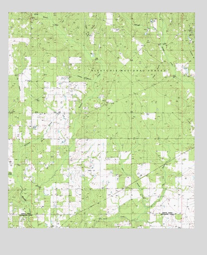
Hurricane Branch, LA USGS Topographic Map
Click on map above to begin viewing in our Map Viewer.

This topographic map contains these locations and features:
Feature Name Type Latitude Longitude GNIS ID View Map
Allen BranchStreamN30.9799°W93.2002°546964View Map
Chasmore (historical)Populated PlaceN30.8982°W93.1729°549987View Map
Clear BranchStreamN30.9621°W93.1377°547219View Map
Clear CreekStreamN30.9060°W93.2454°547224View Map
Diamond Baptist ChurchChurchN30.8964°W93.2264°2601569View Map
Diamond Baptist ChurchChurchN30.8966°W93.2266°554237View Map
Diamond School (historical)SchoolN30.8963°W93.2263°549990View Map
East Branch Black CreekStreamN30.8863°W93.1577°547333View Map
Hogpen BranchStreamN30.9860°W93.1971°547468View Map
Hurricane BranchStreamN30.8966°W93.2404°547491View Map
Jackson BranchStreamN30.9599°W93.1910°547515View Map
Johnson CemeteryCemeteryN30.9449°W93.2077°547525View Map
Johnsonville ChurchChurchN30.9919°W93.1754°547528View Map
Longleaf Scenic AreaLocaleN30.9955°W93.1388°548174View Map
Parish Governing Authority District 7CivilN30.9182°W93.2483°1930215View Map
Pin BranchStreamN30.9435°W93.2493°547838View Map
Providence ChurchChurchN30.9566°W93.2060°547874View Map
Rocky BranchStreamN30.9963°W93.2224°547903View Map
Tennant (historical)Populated PlaceN30.8874°W93.1954°550078View Map
Tighteye CreekStreamN30.9785°W93.1449°548087View Map
Vernon Work CenterLocaleN30.9896°W93.1574°548173View Map
West Branch Black CreekStreamN30.8863°W93.1574°548134View Map
Yoke CreekStreamN30.9916°W93.2179°548163View Map

Note: Coordinates in the location and feature list above are referenced to NAD83 datum.


Copyright (C) 2008-2024 Ryan Niemi / Sunset Dynamics ... All Rights Reserved