TopoQuest Logo
Do you find TopoQuest useful?
Help keep TopoQuest running and adding new maps/features by donating!
Bitcoin:  19c7KJd3qBynnjoSw5npx9KScwjBe4ifkT
Litecoin:  LXs6TkuXGGXo1vDsWCkWVdjQX94eUKd6ui
Home View Maps Find Maps Find Places Resources & Links


Caney, Oklahoma Topographic Map

USGS Map Title: Caney, OK
USGS Map MRC: 34096B2
DRG (GeoTIFF) Download: o34096b2.tif


Neighboring USGS Topographic Map Quads:


  Boggy Depot, OK  
34096C3
 

  Tushka, OK  
34096C2
 

  Bruno, OK  
34096C1
 

  Caddo North, OK  
34096B3
 

  Caney, OK  
34096B2
 

  Bentley, OK  
34096B1
 

  Caddo South, OK  
34096A3
 

  Bokchito, OK  
34096A2
 

  Bennington North, OK  
34096A1


Map MRC Location:

N35°
W97°
N35°
W96°
H8 H7 H6 H5 H4 H3 H2 H1
G8 G7 G6 G5 G4 G3 G2 G1
F8 F7 F6 F5 F4 F3 F2 F1
E8 E7 E6 E5 E4 E3 E2 E1
D8 D7 D6 D5 D4 D3 D2 D1
C8 C7 C6 C5 C4 C3 C2 C1
B8 B7 B6 B5 B4 B3 B2 B1
A8 A7 A6 A5 A4 A3 A2 A1
N34°
W97°
N34°
W96°

Caney, OK USGS 1:24K Topographic Map Preview:
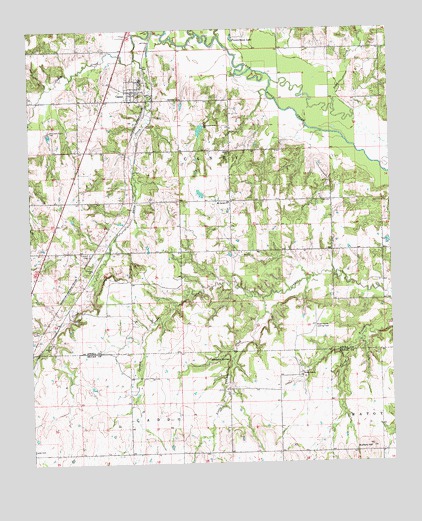
Caney, OK USGS Topographic Map
Click on map above to begin viewing in our Map Viewer.

This topographic map contains these locations and features:
Feature Name Type Latitude Longitude GNIS ID View Map
Bachelor SpringsSpringN34.1548°W96.1819°1089776View Map
Buffalo HillSummitN34.1295°W96.1328°1102109View Map
CaneyPopulated PlaceN34.2323°W96.2142°1090906View Map
Caney CemeteryCemeteryN34.2353°W96.2161°2701841View Map
Caney Creek Site 1 DamDamN34.2251°W96.2386°1757975View Map
Caney Creek Site 1 ReservoirReservoirN34.2243°W96.2381°1757976View Map
Caney Creek Site 2 DamDamN34.2201°W96.2436°1757973View Map
Caney Creek Site 2 ReservoirReservoirN34.2198°W96.2434°1757974View Map
Caney Elementary SchoolSchoolN34.2356°W96.2116°1790588View Map
Caney High SchoolSchoolN34.2351°W96.2121°1790283View Map
Caney Police DepartmentBuildingN34.2339°W96.2121°2757957View Map
Caney Volunteer Fire DepartmentBuildingN34.2336°W96.2121°2657259View Map
Davis CreekStreamN34.2420°W96.2128°1091953View Map
Folsom CemeteryCemeteryN34.1856°W96.2297°1093080View Map
Fronterhouse CreekStreamN34.2479°W96.1836°1093073View Map
Fronterhouse LakeLakeN34.2474°W96.1793°1093074View Map
Little Cowpen CreekStreamN34.1726°W96.1703°1094744View Map
Lower Clear Boggy Site Number 38 DamDamN34.1451°W96.1836°1756353View Map
Lower Clear Boggy Site Number 38 ReservoirReservoirN34.1443°W96.1836°1756354View Map
Mount Carmel ChurchChurchN34.2004°W96.1811°1095562View Map
Nickles LakeReservoirN34.1534°W96.2203°1755738View Map
Nickles Lake DamDamN34.1534°W96.2203°1755737View Map
Sand CreekStreamN34.2104°W96.1283°1097765View Map
Stewart CemeteryCemeteryN34.2362°W96.2158°2701842View Map
Stuart RanchLocaleN34.1501°W96.1572°1098592View Map
Stuart Ranch Airport (historical)AirportN34.1556°W96.1558°1102387View Map
Town of CaneyCivilN34.2356°W96.2170°2413157View Map
Township of CaneyCivilN34.2140°W96.1808°1824969View Map

Note: Coordinates in the location and feature list above are referenced to NAD83 datum.


Copyright (C) 2008-2024 Ryan Niemi / Sunset Dynamics ... All Rights Reserved