TopoQuest Logo
Do you find TopoQuest useful?
Help keep TopoQuest running and adding new maps/features by donating!
Bitcoin:  19c7KJd3qBynnjoSw5npx9KScwjBe4ifkT
Litecoin:  LXs6TkuXGGXo1vDsWCkWVdjQX94eUKd6ui
Home View Maps Find Maps Find Places Resources & Links


Jackson, Wisconsin Topographic Map

USGS Map Title: Jackson, WI
USGS Map MRC: 43088C2
DRG (GeoTIFF) Download: o43088c2.tif


Neighboring USGS Topographic Map Quads:


  Allenton, WI  
43088D3
 

  West Bend, WI  
43088D2
 

  Newburg, WI  
43088D1
 

  Hartford East, WI  
43088C3
 

  Jackson, WI  
43088C2
 

  Five Corners, WI  
43088C1
 

  Merton, WI  
43088B3
 

  Sussex, WI  
43088B2
 

  Menomonee Falls, WI  
43088B1


Map MRC Location:

N44°
W89°
N44°
W88°
H8 H7 H6 H5 H4 H3 H2 H1
G8 G7 G6 G5 G4 G3 G2 G1
F8 F7 F6 F5 F4 F3 F2 F1
E8 E7 E6 E5 E4 E3 E2 E1
D8 D7 D6 D5 D4 D3 D2 D1
C8 C7 C6 C5 C4 C3 C2 C1
B8 B7 B6 B5 B4 B3 B2 B1
A8 A7 A6 A5 A4 A3 A2 A1
N43°
W89°
N43°
W88°

Jackson, WI USGS 1:24K Topographic Map Preview:
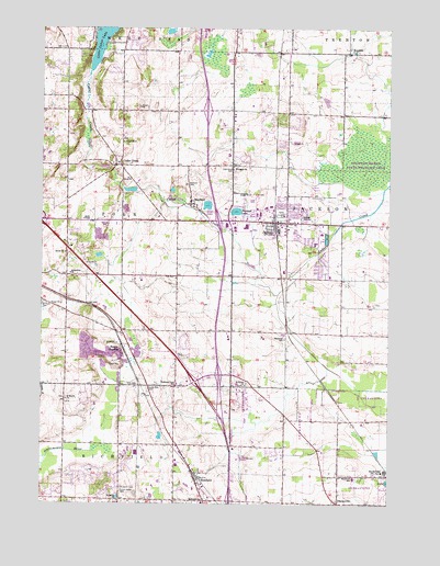
Jackson, WI USGS Topographic Map
Click on map above to begin viewing in our Map Viewer.

This topographic map contains these locations and features:
Feature Name Type Latitude Longitude GNIS ID View Map
Ackerville ChurchChurchN43.3106°W88.2398°1560675View Map
Arrowhead Springs Airport (historical)AirportN43.2536°W88.2095°1582179View Map
Cedar CreekPopulated PlaceN43.3397°W88.2229°1562834View Map
Cedar Creek FarmLocaleN43.3372°W88.1758°2706421View Map
Cedar Park CemeteryCemeteryN43.2807°W88.2122°1562863View Map
Christus KircheChurchN43.2506°W88.1431°1840898View Map
Coney RiverStreamN43.2617°W88.2484°1563316View Map
DheinsvillePopulated PlaceN43.2500°W88.1429°1563958View Map
Dheinsville Historic ParkParkN43.2506°W88.1422°2120132View Map
Elmwood SchoolSchoolN43.2933°W88.1623°1564588View Map
Erler CemeteryCemeteryN43.2813°W88.2154°1564692View Map
Forest Home CemeteryCemeteryN43.2537°W88.2214°1565125View Map
Friedens ChurchChurchN43.3389°W88.1809°1565327View Map
Hasmer LakeLakeN43.3268°W88.1803°1566122View Map
Heckendorf FarmLocaleN43.3072°W88.1403°2706422View Map
Highway View SchoolSchoolN43.2814°W88.2009°1566403View Map
Hoeferts FarmsLocaleN43.3633°W88.1953°2706504View Map
Interchange 57CrossingN43.2508°W88.1817°2357000View Map
Interchange 59CrossingN43.2722°W88.1850°2356999View Map
Interchange 60CrossingN43.2822°W88.1947°2356998View Map
JacksonPopulated PlaceN43.3239°W88.1668°1567062View Map
Jackson Elementary SchoolSchoolN43.3247°W88.1612°1840933View Map
Jackson Fire DepartmentBuildingN43.3223°W88.1613°2698068View Map
Jackson Police DepartmentBuildingN43.3237°W88.1650°2759769View Map
Jackson Wastewater Treatment PlantLocaleN43.3194°W88.1492°2723890View Map
KeownsPopulated PlaceN43.3686°W88.1362°1577675View Map
Keowns PondLakeN43.3689°W88.1377°2761839View Map
Kettle Moraine Lutheran High SchoolSchoolN43.3127°W88.1252°2716757View Map
Kison FarmLocaleN43.3083°W88.2147°2706423View Map
Kissinger FarmsLocaleN43.3122°W88.1994°2706424View Map
Last Home CemeteryCemeteryN43.3384°W88.1809°1567868View Map
Lehner LakeLakeN43.3151°W88.2294°2761842View Map
Lent LakeLakeN43.3382°W88.2265°2761843View Map
Living Word Lutheran High SchoolSchoolN43.3272°W88.1493°2716341View Map
Maple Woods FarmLocaleN43.3503°W88.1964°2706507View Map
Maxon CemeteryCemeteryN43.3450°W88.2209°1569138View Map
MayfieldPopulated PlaceN43.3292°W88.1968°1569145View Map
Mayfield CemeteryCemeteryN43.3342°W88.1981°1569147View Map
Melius FarmsLocaleN43.3106°W88.2089°2706425View Map
Merten FarmsLocaleN43.3364°W88.2378°2706479View Map
Morning Star Evangelical Lutheran ChurchChurchN43.3304°W88.1584°2516932View Map
Morning Star Lutheran SchoolSchoolN43.3303°W88.1586°2516931View Map
Quas LakeLakeN43.3740°W88.2043°2761848View Map
RichfieldPopulated PlaceN43.2561°W88.1940°1572285View Map
Richfield Elementary SchoolSchoolN43.2501°W88.1922°1572287View Map
Richfield Volunteer Fire Company Station 1BuildingN43.2601°W88.1961°2698073View Map
RockfieldPopulated PlaceN43.2575°W88.1262°1572481View Map
Rockfield Elementary SchoolSchoolN43.2567°W88.1374°1572482View Map
Rockfield Quarry PondReservoirN43.2558°W88.1252°2761850View Map
Rugby JunctionPopulated PlaceN43.2919°W88.2187°1577803View Map
Rugby PitMineN43.2889°W88.2264°2634047View Map
Saint Jacobi CemeteryCemeteryN43.2544°W88.2214°1572969View Map
Saint Jacobi ChurchChurchN43.2508°W88.2218°1572970View Map
Saint Joseph's HospitalHospitalN43.3558°W88.1951°2698451View Map
Saint Marys ChurchChurchN43.2775°W88.2409°1573314View Map
Saint Pauls CemeteryCemeteryN43.3028°W88.2495°1573463View Map
Saint Peters ChurchChurchN43.2811°W88.1765°1573529View Map
Schwietzer PondLakeN43.3323°W88.2032°2761851View Map
Tilly LakeLakeN43.3284°W88.1905°1575456View Map
Town of GermantownCivilN43.2723°W88.1574°1583270View Map
Town of PolkCivilN43.3249°W88.2113°1583950View Map
Village of JacksonCivilN43.3244°W88.1668°1583443View Map
Washington CountyCivilN43.3685°W88.2308°1581125View Map
WBKV-AM (West Bend)TowerN43.3706°W88.1662°1582369View Map
WYLO-AM (Jackson)TowerN43.3333°W88.1529°1582306View Map

Note: Coordinates in the location and feature list above are referenced to NAD83 datum.


Copyright (C) 2008-2025 Ryan Niemi / Sunset Dynamics ... All Rights Reserved