TopoQuest Logo
Do you find TopoQuest useful?
Help keep TopoQuest running and adding new maps/features by donating!
Bitcoin:  19c7KJd3qBynnjoSw5npx9KScwjBe4ifkT
Litecoin:  LXs6TkuXGGXo1vDsWCkWVdjQX94eUKd6ui
Home View Maps Find Maps Find Places Resources & Links


Allenton, Wisconsin Topographic Map

USGS Map Title: Allenton, WI
USGS Map MRC: 43088D3
DRG (GeoTIFF) Download: o43088d3.tif


Neighboring USGS Topographic Map Quads:


  Lomira, WI  
43088E4
 

  Campbellsport, WI  
43088E3
 

  Kewaskum, WI  
43088E2
 

  Nenno, WI  
43088D4
 

  Allenton, WI  
43088D3
 

  West Bend, WI  
43088D2
 

  Hartford West, WI  
43088C4
 

  Hartford East, WI  
43088C3
 

  Jackson, WI  
43088C2


Map MRC Location:

N44°
W89°
N44°
W88°
H8 H7 H6 H5 H4 H3 H2 H1
G8 G7 G6 G5 G4 G3 G2 G1
F8 F7 F6 F5 F4 F3 F2 F1
E8 E7 E6 E5 E4 E3 E2 E1
D8 D7 D6 D5 D4 D3 D2 D1
C8 C7 C6 C5 C4 C3 C2 C1
B8 B7 B6 B5 B4 B3 B2 B1
A8 A7 A6 A5 A4 A3 A2 A1
N43°
W89°
N43°
W88°

Allenton, WI USGS 1:24K Topographic Map Preview:
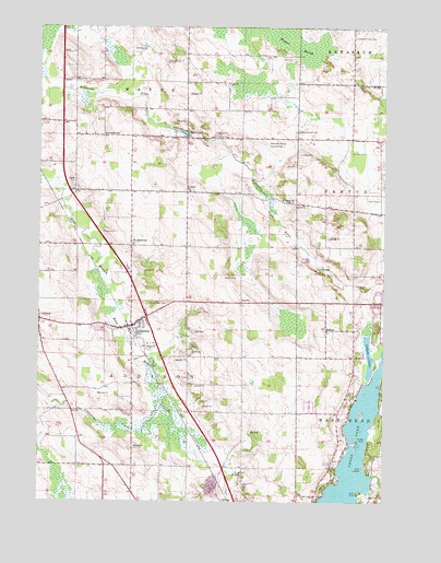
Allenton, WI USGS Topographic Map
Click on map above to begin viewing in our Map Viewer.

This topographic map contains these locations and features:
Feature Name Type Latitude Longitude GNIS ID View Map
AddisonPopulated PlaceN43.4228°W88.3745°1560691View Map
Addison Elementary SchoolSchoolN43.3754°W88.2980°2716565View Map
Albright Evangelical United Brethren CemeteryCemeteryN43.4728°W88.2823°1575916View Map
AllentonPopulated PlaceN43.4206°W88.3409°1560781View Map
Allenton Census Designated PlaceCensusN43.4205°W88.3444°2585056View Map
Allenton CreekStreamN43.3972°W88.3270°1577405View Map
Allenton Elementary SchoolSchoolN43.4164°W88.3354°1840887View Map
Allenton Volunteer Fire DepartmentBuildingN43.4184°W88.3418°2697762View Map
AuroraPopulated PlaceN43.4275°W88.3018°1561019View Map
Brittany FarmsLocaleN43.4100°W88.3536°2706480View Map
Cedar LakeLakeN43.3842°W88.2626°1562856View Map
Dominion Valley FarmLocaleN43.4958°W88.3639°2706481View Map
Dornacker Prairie AcresLocaleN43.3969°W88.2881°2706431View Map
Echo PointCapeN43.3775°W88.2587°1564432View Map
Four Way FarmsLocaleN43.4514°W88.3392°2706430View Map
Garden View DairyLocaleN43.4725°W88.3564°2706482View Map
Gilbert LakeLakeN43.4133°W88.2555°1565514View Map
Goeller Family FarmsLocaleN43.3783°W88.3539°2706510View Map
Hahn Sky Ranch AirportAirportN43.4697°W88.2926°1582266View Map
Highview FarmLocaleN43.4350°W88.2508°2706503View Map
Ihlenfeld FarmsLocaleN43.4472°W88.3197°2559672View Map
Interchange 72CrossingN43.4236°W88.3361°2356994View Map
Interchange 76CrossingN43.4750°W88.3667°2356993View Map
Kedinger FarmsLocaleN43.3978°W88.2692°2706506View Map
Kewaskum Union CemeteryCemeteryN43.4975°W88.2618°1567444View Map
KohlsvillePopulated PlaceN43.4711°W88.3220°1567604View Map
Kohlsville MillpondReservoirN43.4716°W88.3219°2761841View Map
Kohlsville SchoolSchoolN43.4717°W88.3518°1567606View Map
Kohlsville Volunteer Fire DepartmentBuildingN43.4699°W88.3213°2697619View Map
L - J FarmsLocaleN43.3853°W88.2828°2706428View Map
Limestone CreekStreamN43.4003°W88.3301°1568063View Map
Linden PointCapeN43.3914°W88.2593°1568135View Map
Lone IslandIslandN43.4039°W88.2568°1840943View Map
NabobPopulated PlaceN43.4203°W88.2709°1570093View Map
Point LookoutCapeN43.3839°W88.2573°1571724View Map
Proeber DairyLocaleN43.4503°W88.3244°2706513View Map
Sacred Heart CemeteryCemeteryN43.4272°W88.3286°1572780View Map
Saint AnthonyPopulated PlaceN43.4425°W88.3418°1572840View Map
Saint Johns SchoolSchoolN43.4567°W88.3209°1573127View Map
Saint Peters ChurchChurchN43.4542°W88.2837°1573530View Map
Schelle PitMineN43.4306°W88.2503°2711477View Map
Sunset FarmsLocaleN43.4186°W88.3661°2706427View Map
Town of AddisonCivilN43.4130°W88.3413°1582657View Map
Town of WayneCivilN43.4999°W88.3411°1584389View Map
Twisted Pine FarmLocaleN43.4664°W88.3631°2706485View Map
Wayne CreekStreamN43.4833°W88.3476°1576353View Map
Wayne MarshSwampN43.4994°W88.2920°1576354View Map
WBWI-FM (West Bend)TowerN43.4292°W88.2982°1582490View Map
Whispering View FarmLocaleN43.4150°W88.3242°2706486View Map

Note: Coordinates in the location and feature list above are referenced to NAD83 datum.


Copyright (C) 2008-2024 Ryan Niemi / Sunset Dynamics ... All Rights Reserved