TopoQuest Logo
Do you find TopoQuest useful?
Help keep TopoQuest running and adding new maps/features by donating!
Bitcoin:  19c7KJd3qBynnjoSw5npx9KScwjBe4ifkT
Litecoin:  LXs6TkuXGGXo1vDsWCkWVdjQX94eUKd6ui
Home View Maps Find Maps Find Places Resources & Links


Laguna Peak, New Mexico Topographic Map

USGS Map Title: Laguna Peak, NM
USGS Map MRC: 36106C6
DRG (GeoTIFF) Download: o36106c6.tif


Neighboring USGS Topographic Map Quads:


  Llaves, NM  
36106D7
 

  Navajo Peak, NM  
36106D6
 

  Alire, NM  
36106D5
 

  French Mesa, NM  
36106C7
 

  Laguna Peak, NM  
36106C6
 

  Echo Amphitheater, NM  
36106C5
 

  Gallina, NM  
36106B7
 

  Arroyo Del Agua, NM  
36106B6
 

  Youngsville, NM  
36106B5


Map MRC Location:

N37°
W107°
N37°
W106°
H8 H7 H6 H5 H4 H3 H2 H1
G8 G7 G6 G5 G4 G3 G2 G1
F8 F7 F6 F5 F4 F3 F2 F1
E8 E7 E6 E5 E4 E3 E2 E1
D8 D7 D6 D5 D4 D3 D2 D1
C8 C7 C6 C5 C4 C3 C2 C1
B8 B7 B6 B5 B4 B3 B2 B1
A8 A7 A6 A5 A4 A3 A2 A1
N36°
W107°
N36°
W106°

Laguna Peak, NM USGS 1:24K Topographic Map Preview:
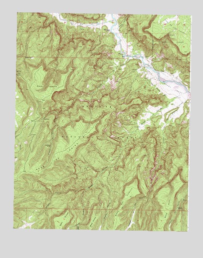
Laguna Peak, NM USGS Topographic Map
Click on map above to begin viewing in our Map Viewer.

This topographic map contains these locations and features:
Feature Name Type Latitude Longitude GNIS ID View Map
Bear SpringSpringN36.2585°W106.7439°913802View Map
Caņada CaminoStreamN36.2808°W106.6898°904441View Map
Caņada CorralStreamN36.2525°W106.7039°904447View Map
Caņada de la FuertesStreamN36.3278°W106.6264°904354View Map
Caņada de la PresaStreamN36.3506°W106.6689°904347View Map
Caņada GuruleStreamN36.3308°W106.6278°904455View Map
Caņada SchmidtStreamN36.2736°W106.6975°904480View Map
Canon de Chama GrantCivilN36.3370°W106.6461°904646View Map
Chama River Canyon WildernessReserveN36.3351°W106.6614°924223View Map
Chavez CanyonValleyN36.3661°W106.6817°905054View Map
Gallegos SpringSpringN36.3491°W106.7437°906444View Map
Gallina Bench RanchLocaleN36.3656°W106.6825°906445View Map
Laguna PeakSummitN36.3395°W106.7489°907789View Map
Little Bear SpringSpringN36.2562°W106.6588°2677945View Map
Los Indios SpringSpringN36.2983°W106.7246°908215View Map
Los OjitosSpringN36.3097°W106.6609°908219View Map
Lower Fuertes SpringSpringN36.2533°W106.6651°2677946View Map
Mesa LagunaSummitN36.3300°W106.7256°908618View Map
Mesa los IndiosSummitN36.2917°W106.7211°908620View Map
Ojitos CanyonValleyN36.3308°W106.6278°909279View Map
Ojitos TrailTrailN36.3133°W106.6544°2677948View Map
Potrero Four SpringSpringN36.2682°W106.6292°2677944View Map
Potrero One SpringSpringN36.2557°W106.6344°2677942View Map
Potrero Three SpringSpringN36.2635°W106.6326°909821View Map
Potrero Two SpringSpringN36.2683°W106.6519°2677943View Map
Presa SpringSpringN36.3137°W106.7299°909845View Map
Rincon SpringSpringN36.3031°W106.6974°2677949View Map
Rio GallinaStreamN36.3706°W106.6786°910239View Map
Screaming Left Hand TurnRapidsN36.3508°W106.6736°925096View Map
Wild Blue MineMineN36.3436°W106.7306°939916View Map

Note: Coordinates in the location and feature list above are referenced to NAD83 datum.


Copyright (C) 2008-2024 Ryan Niemi / Sunset Dynamics ... All Rights Reserved