TopoQuest Logo
Do you find TopoQuest useful?
Help keep TopoQuest running and adding new maps/features by donating!
Bitcoin:  19c7KJd3qBynnjoSw5npx9KScwjBe4ifkT
Litecoin:  LXs6TkuXGGXo1vDsWCkWVdjQX94eUKd6ui
Home View Maps Find Maps Find Places Resources & Links


Little Hocking, Ohio Topographic Map

USGS Map Title: Little Hocking, OH
USGS Map MRC: 39081C6
DRG (GeoTIFF) Download: o39081c6.tif


Neighboring USGS Topographic Map Quads:


  Chesterhill, OH  
39081D7
 

  Watertown, OH  
39081D6
 

  Fleming, OH  
39081D5
 

  Cutler, OH  
39081C7
 

  Little Hocking, OH  
39081C6
 

  Parkersburg, WV  
39081C5
 

  Coolville, OH  
39081B7
 

  Lubeck, WV  
39081B6
 

  South Parkersburg, WV  
39081B5


Map MRC Location:

N40°
W82°
N40°
W81°
H8 H7 H6 H5 H4 H3 H2 H1
G8 G7 G6 G5 G4 G3 G2 G1
F8 F7 F6 F5 F4 F3 F2 F1
E8 E7 E6 E5 E4 E3 E2 E1
D8 D7 D6 D5 D4 D3 D2 D1
C8 C7 C6 C5 C4 C3 C2 C1
B8 B7 B6 B5 B4 B3 B2 B1
A8 A7 A6 A5 A4 A3 A2 A1
N39°
W82°
N39°
W81°

Little Hocking, OH USGS 1:24K Topographic Map Preview:
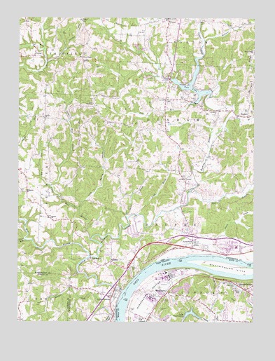
Little Hocking, OH USGS Topographic Map
Click on map above to begin viewing in our Map Viewer.

This topographic map contains these locations and features:
Feature Name Type Latitude Longitude GNIS ID View Map
Barnes CemeteryCemeteryN39.2501°W81.6701°1535255View Map
Barnett RidgeRidgeN39.3562°W81.6268°1037642View Map
Barnett Ridge CemeteryCemeteryN39.3617°W81.6251°1963878View Map
Big RunStreamN39.3062°W81.7326°1038019View Map
BlennerhassettPopulated PlaceN39.2637°W81.6293°1536097View Map
Blennerhassett Census Designated PlaceCensusN39.2563°W81.6316°2389216View Map
Blennerhassett IslandIslandN39.2712°W81.6257°1536098View Map
Blennerhassett Island BridgeBridgeN39.2757°W81.6467°2647203View Map
Blennerhassett Island Historical State ParkParkN39.2712°W81.6262°1560348View Map
Buffalo RunStreamN39.3659°W81.6524°1038492View Map
Coal HollowValleyN39.2687°W81.6460°1537452View Map
Cold Spring HollowValleyN39.2970°W81.7176°1039239View Map
CornerPopulated PlaceN39.3090°W81.6618°1062714View Map
Corner CemeteryCemeteryN39.3024°W81.6621°1039376View Map
Davis CreekStreamN39.2776°W81.6393°1061017View Map
Decatur ChurchChurchN39.2931°W81.7329°1039635View Map
Decatur Methodist Episcopal CemeteryCemeteryN39.2934°W81.7321°1963892View Map
Decatur Presbyterian CemeteryCemeteryN39.3334°W81.7364°1963893View Map
Decatur Presbyterian Church (historical)ChurchN39.3337°W81.7360°1039636View Map
DunbarPopulated PlaceN39.3595°W81.7418°1061026View Map
DunhamPopulated PlaceN39.3348°W81.6279°1062739View Map
Dunham Township Volunteer Fire DepartmentBuildingN39.3414°W81.6672°2549386View Map
East Branch Little Hocking RiverStreamN39.3348°W81.6357°1066696View Map
Edelen CemeteryCemeteryN39.2715°W81.6560°1538547View Map
Fairchild ChurchChurchN39.3579°W81.7160°1040304View Map
Fairfield Church CemeteryCemeteryN39.3578°W81.7154°1963897View Map
FillmorePopulated PlaceN39.3034°W81.7451°1062761View Map
Full Gospel TempleChurchN39.3337°W81.7360°1963901View Map
General Electric Plastics Medical UnitBuildingN39.2595°W81.6775°2581145View Map
Goodnoughs LandingLocaleN39.2776°W81.6449°1050615View Map
Gospel TabernacleChurchN39.3398°W81.7107°1040982View Map
Grass RunStreamN39.2837°W81.7462°1075952View Map
Highland LakeReservoirN39.2653°W81.6343°1540264View Map
Holiday Tree FarmLocaleN39.3378°W81.7119°2647903View Map
Hopkins CemeteryCemeteryN39.3417°W81.6556°1041786View Map
Lake RonReservoirN39.2633°W81.6317°1546055View Map
Lake WashingtonReservoirN39.2540°W81.6570°1548828View Map
Lake Washington DamDamN39.2534°W81.6615°1560618View Map
Lewis CemeteryCemeteryN39.2620°W81.6832°1534769View Map
Lewis CemeteryCemeteryN39.2556°W81.6897°1541806View Map
Lewis LandingLocaleN39.2779°W81.6507°1050614View Map
Little HockingPopulated PlaceN39.2606°W81.6999°1065009View Map
Little Hocking CemeteryCemeteryN39.2605°W81.7006°1963915View Map
Little Hocking Census Designated PlaceCensusN39.2607°W81.7019°2628926View Map
Little Hocking Elementary SchoolSchoolN39.2576°W81.7015°1050610View Map
Little Hocking Fire DepartmentBuildingN39.2736°W81.6915°2549557View Map
Little Hocking RiverStreamN39.2631°W81.6943°1066810View Map
Little West Branch Little Hocking RiverStreamN39.2840°W81.7112°1042695View Map
Lock and Dam Number 19DamN39.2567°W81.6935°1557806View Map
Lock and Dam Number 19 (historical)DamN39.2562°W81.6943°1050611View Map
Long BrookStreamN39.2945°W81.6862°1042732View Map
McDougle CemeteryCemeteryN39.2554°W81.6740°1542991View Map
Mill BranchStreamN39.3037°W81.6579°1043320View Map
NapierPopulated PlaceN39.3737°W81.7168°1062913View Map
Neal CemeteryCemeteryN39.2695°W81.6749°1544064View Map
Neale CemeteryCemeteryN39.2617°W81.6823°1986792View Map
Ohio Power Company Dam Number ThreeDamN39.2551°W81.7249°1077705View Map
Ohio Power Pond Number ThreeReservoirN39.2551°W81.7249°1077706View Map
Oxbow Golf CourseLocaleN39.3148°W81.6518°1050613View Map
Plum RunStreamN39.3395°W81.6599°1044641View Map
PorterfieldPopulated PlaceN39.2834°W81.6557°1071054View Map
Quaker CemeteryCemeteryN39.3034°W81.7474°1044809View Map
RedbushPopulated PlaceN39.2748°W81.7004°1049114View Map
Richards CemeteryCemeteryN39.2645°W81.6379°1986803View Map
Saint Marys CemeteryCemeteryN39.2731°W81.6887°1045640View Map
Sawyer RunStreamN39.2551°W81.6979°1060546View Map
Short BrookStreamN39.2937°W81.6926°1046241View Map
Tick RidgePopulated PlaceN39.3590°W81.7162°1063059View Map
Township of BelpreCivilN39.2826°W81.6664°1087128View Map
Township of DunhamCivilN39.3320°W81.6378°1087130View Map
Tupper CreekStreamN39.3595°W81.6526°1067020View Map
Twin BridgesLocaleN39.2762°W81.7112°1047243View Map
VetoPopulated PlaceN39.3417°W81.6724°1065436View Map
Veto CemeteryCemeteryN39.3451°W81.6707°1963942View Map
Veto LakeReservoirN39.3480°W81.6578°1070976View Map
Veto Lake DamDamN39.3454°W81.6474°1078389View Map
Veto Lake Wildlife AreaParkN39.3473°W81.6612°1050612View Map
Veto Presbyterian ChurchChurchN39.3423°W81.6715°1060589View Map
Vincent Census Designated PlaceCensusN39.3749°W81.6710°2628983View Map
WashingtonPopulated PlaceN39.2612°W81.6718°1548816View Map
Washington BottomBendN39.2606°W81.6804°1548817View Map
Washington Post OfficePost OfficeN39.2615°W81.6710°1560536View Map
West Branch Little Hocking RiverStreamN39.2773°W81.7115°1077164View Map
WEYQ-FM (Marietta)TowerN39.3242°W81.6257°1085380View Map
WHCM-FM (Parkersburg)TowerN39.2876°W81.6568°1559821View Map
Whites RunStreamN39.2520°W81.6982°1058137View Map

Note: Coordinates in the location and feature list above are referenced to NAD83 datum.


Copyright (C) 2008-2025 Ryan Niemi / Sunset Dynamics ... All Rights Reserved