TopoQuest Logo
Do you find TopoQuest useful?
Help keep TopoQuest running and adding new maps/features by donating!
Bitcoin:  19c7KJd3qBynnjoSw5npx9KScwjBe4ifkT
Litecoin:  LXs6TkuXGGXo1vDsWCkWVdjQX94eUKd6ui
Home View Maps Find Maps Find Places Resources & Links


Chesterhill, Ohio Topographic Map

USGS Map Title: Chesterhill, OH
USGS Map MRC: 39081D7
DRG (GeoTIFF) Download: o39081d7.tif


Neighboring USGS Topographic Map Quads:


  Ringgold, OH  
39081E8
 

  Stockport, OH  
39081E7
 

  Beverly, OH  
39081E6
 

  Amesville, OH  
39081D8
 

  Chesterhill, OH  
39081D7
 

  Watertown, OH  
39081D6
 

  Stewart, OH  
39081C8
 

  Cutler, OH  
39081C7
 

  Little Hocking, OH  
39081C6


Map MRC Location:

N40°
W82°
N40°
W81°
H8 H7 H6 H5 H4 H3 H2 H1
G8 G7 G6 G5 G4 G3 G2 G1
F8 F7 F6 F5 F4 F3 F2 F1
E8 E7 E6 E5 E4 E3 E2 E1
D8 D7 D6 D5 D4 D3 D2 D1
C8 C7 C6 C5 C4 C3 C2 C1
B8 B7 B6 B5 B4 B3 B2 B1
A8 A7 A6 A5 A4 A3 A2 A1
N39°
W82°
N39°
W81°

Chesterhill, OH USGS 1:24K Topographic Map Preview:
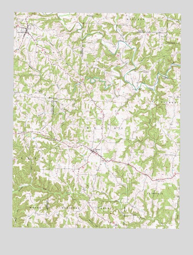
Chesterhill, OH USGS Topographic Map
Click on map above to begin viewing in our Map Viewer.

This topographic map contains these locations and features:
Feature Name Type Latitude Longitude GNIS ID View Map
Aldridge RunStreamN39.4837°W81.7932°1075248View Map
BartlettPopulated PlaceN39.4195°W81.8157°1075313View Map
Bartlett CemeteryCemeteryN39.4237°W81.8235°1037657View Map
Bartlett Elementary SchoolSchoolN39.4187°W81.8118°1050692View Map
Bartlett Friends CemeteryCemeteryN39.4262°W81.8096°1075884View Map
Bethel CemeteryCemeteryN39.4534°W81.8549°1964202View Map
Bethel Methodist Church (historical)ChurchN39.4534°W81.8557°1068859View Map
Bethel Ridge Apostolic TabernacleChurchN39.4534°W81.8557°1075366View Map
Brill RunStreamN39.3995°W81.8615°1075442View Map
Buckeye RunStreamN39.4412°W81.8371°1075471View Map
Burt CemeteryCemeteryN39.4667°W81.7854°1075494View Map
ChesterhillPopulated PlaceN39.4884°W81.8660°1075570View Map
Chesterhill CemeteryCemeteryN39.4912°W81.8624°1964204View Map
Chesterhill Church of the NazareneChurchN39.4867°W81.8674°1068875View Map
Chesterhill Post OfficePost OfficeN39.4890°W81.8665°2037888View Map
Chesterhill United Methodist ChurchChurchN39.4876°W81.8637°1068876View Map
Chesterhill Volunteer Fire and Emergency Medical ServicesBuildingN39.4872°W81.8635°2550532View Map
Coal RunStreamN39.4676°W81.7862°1075595View Map
DalePopulated PlaceN39.4890°W81.7665°1075672View Map
Downtown Chesterhill Historic DistrictParkN39.4895°W81.8654°1071646View Map
Epworth ChurchChurchN39.4662°W81.7779°1075812View Map
Fairview ChurchChurchN39.4873°W81.7612°1075829View Map
Fairview Church CemeteryCemeteryN39.4873°W81.7618°1963899View Map
Henry BridgeBridgeN39.3834°W81.7851°1050693View Map
Laurel RunStreamN39.4551°W81.7701°1076212View Map
Liberty CemeteryCemeteryN39.4681°W81.8126°1963914View Map
Liberty ChurchChurchN39.4681°W81.8135°1076241View Map
Marion Elementary SchoolSchoolN39.4890°W81.8693°1051213View Map
Mile RunStreamN39.4262°W81.8371°1050691View Map
Mission CemeteryCemeteryN39.3826°W81.8396°1076410View Map
Mount Herman CemeteryCemeteryN39.4301°W81.8699°1699517View Map
Mount Hermon ChurchChurchN39.4301°W81.8690°1076447View Map
North Branch Coal RunStreamN39.4531°W81.8318°1076523View Map
Old Quaker CemeteryCemeteryN39.4870°W81.8640°1964219View Map
Patten MillsPopulated PlaceN39.4573°W81.7815°1076597View Map
Quaker CemeteryCemeteryN39.4142°W81.8060°1058198View Map
Shinn BridgeBridgeN39.4629°W81.7610°1050694View Map
Shrader RunStreamN39.4626°W81.8215°1076889View Map
Smith CemeteryCemeteryN39.4352°W81.8047°1076921View Map
Southland MissionChurchN39.3770°W81.8351°1076938View Map
Southland Mission CemeteryCemeteryN39.3767°W81.8354°1807290View Map
Tabor CemeteryCemeteryN39.4984°W81.8168°1964225View Map
Tabor Church of ChristChurchN39.4979°W81.8185°1077024View Map
Township of WesleyCivilN39.4266°W81.8080°1087147View Map
Union CemeteryCemeteryN39.4031°W81.7668°1077098View Map
Village of ChesterhillCivilN39.4907°W81.8667°2397618View Map
Walnut RunStreamN39.4698°W81.7840°1077132View Map
Wesley Township Volunteer Fire DepartmentBuildingN39.4179°W81.8118°2549799View Map
Wesleyan CemeteryCemeteryN39.4480°W81.8451°1807282View Map
Wesleyan ChurchChurchN39.4484°W81.8454°1077160View Map
Wilson CemeteryCemeteryN39.4765°W81.7958°1077202View Map

Note: Coordinates in the location and feature list above are referenced to NAD83 datum.


Copyright (C) 2008-2025 Ryan Niemi / Sunset Dynamics ... All Rights Reserved