TopoQuest Logo
Do you find TopoQuest useful?
Help keep TopoQuest running and adding new maps/features by donating!
Bitcoin:  19c7KJd3qBynnjoSw5npx9KScwjBe4ifkT
Litecoin:  LXs6TkuXGGXo1vDsWCkWVdjQX94eUKd6ui
Home View Maps Find Maps Find Places Resources & Links


Canoe, Kentucky Topographic Map

USGS Map Title: Canoe, KY
USGS Map MRC: 37083D4
DRG (GeoTIFF) Download: o37083d4.tif


Neighboring USGS Topographic Map Quads:


  Tallega, KY  
37083E5
 

  Jackson, KY  
37083E4
 

  Quicksand, KY  
37083E3
 

  Cowcreek, KY  
37083D5
 

  Canoe, KY  
37083D4
 

  Haddix, KY  
37083D3
 

  Mistletoe, KY  
37083C5
 

  Buckhorn, KY  
37083C4
 

  Krypton, KY  
37083C3


Map MRC Location:

N38°
W84°
N38°
W83°
H8 H7 H6 H5 H4 H3 H2 H1
G8 G7 G6 G5 G4 G3 G2 G1
F8 F7 F6 F5 F4 F3 F2 F1
E8 E7 E6 E5 E4 E3 E2 E1
D8 D7 D6 D5 D4 D3 D2 D1
C8 C7 C6 C5 C4 C3 C2 C1
B8 B7 B6 B5 B4 B3 B2 B1
A8 A7 A6 A5 A4 A3 A2 A1
N37°
W84°
N37°
W83°

Canoe, KY USGS 1:24K Topographic Map Preview:
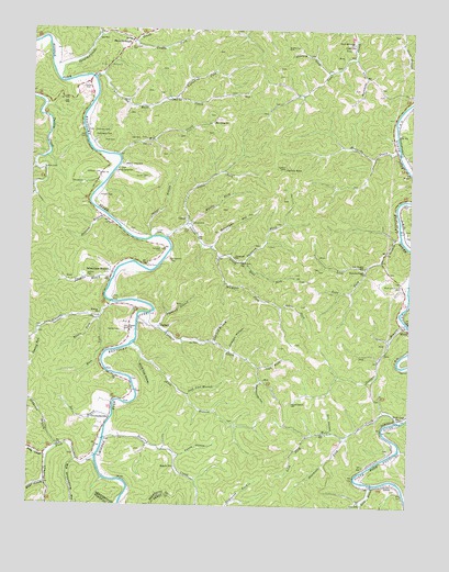
Canoe, KY USGS Topographic Map
Click on map above to begin viewing in our Map Viewer.

This topographic map contains these locations and features:
Feature Name Type Latitude Longitude GNIS ID View Map
Allen ForkStreamN37.4273°W83.4180°510244View Map
AltroPopulated PlaceN37.3809°W83.3821°510251View Map
Altro SchoolSchoolN37.3754°W83.3899°510252View Map
Anderson CemeteryCemeteryN37.4731°W83.4793°510267View Map
Arrowood SchoolSchoolN37.4401°W83.4330°510303View Map
Beech Grove ChurchChurchN37.4631°W83.4713°510522View Map
Beech Grove SchoolSchoolN37.4643°W83.4691°510524View Map
Beech P OLocaleN37.3851°W83.4513°510526View Map
Big Groundhog HollowValleyN37.3868°W83.4839°510661View Map
Bowlin Cove CemeteryCemeteryN37.4956°W83.4166°510871View Map
Bowling CreekStreamN37.3923°W83.4746°510874View Map
Bush BranchStreamN37.3806°W83.3866°511093View Map
Butterpoint CemeteryCemeteryN37.4395°W83.4538°511103View Map
Buzzard ForkStreamN37.4390°W83.4296°511110View Map
Callahan CemeteryCemeteryN37.4417°W83.4571°511131View Map
Callahan CemeteryCemeteryN37.4620°W83.4777°511132View Map
CanoePopulated PlaceN37.4490°W83.4485°511206View Map
Canoe CreekStreamN37.4387°W83.4293°511207View Map
Canoe DivisionCivilN37.4271°W83.4759°1936918View Map
Canoe HollowValleyN37.3882°W83.4502°511210View Map
Canoe Volunteer Fire DepartmentBuildingN37.4973°W83.4659°2637227View Map
Combs CemeteryCemeteryN37.4595°W83.4830°511486View Map
Combs CemeteryCemeteryN37.4854°W83.4818°511487View Map
Combs ForkStreamN37.4968°W83.4663°511490View Map
CrockettsvillePopulated PlaceN37.3968°W83.4741°511646View Map
Curt P OLocaleN37.4959°W83.3943°511685View Map
Dill HollowValleyN37.3945°W83.4000°511814View Map
Drew Memorial ChurchChurchN37.4968°W83.3943°511885View Map
Elisha Gross CemeteryCemeteryN37.4765°W83.4641°2746996View Map
Elsome ChurchChurchN37.4251°W83.4766°512062View Map
Elsome CreekStreamN37.4281°W83.4732°512063View Map
Figured Beech CemeteryCemeteryN37.4020°W83.4132°512157View Map
Fourmile ForkStreamN37.4634°W83.4982°512227View Map
Freeman ForkStreamN37.3876°W83.4777°512251View Map
Georges BranchStreamN37.4226°W83.3755°512298View Map
Griffith CemeteryCemeteryN37.4351°W83.4810°512466View Map
Griffith CemeteryCemeteryN37.4631°W83.4960°512467View Map
Gum Log BranchStreamN37.4179°W83.4396°512483View Map
Hall CemeteryCemeteryN37.4695°W83.4641°512520View Map
Hall CemeteryCemeteryN37.4709°W83.4643°512521View Map
Herald CemeteryCemeteryN37.4209°W83.4693°512668View Map
Holland BranchStreamN37.4506°W83.4746°512742View Map
Holland CemeteryCemeteryN37.4562°W83.4777°512746View Map
Hounshell CemeteryCemeteryN37.4956°W83.4677°512811View Map
Howard ForkStreamN37.4890°W83.4024°512818View Map
Howards CreekStreamN37.4681°W83.3791°512820View Map
Howards Creek ChurchChurchN37.4365°W83.3899°512821View Map
Jack Lick BranchStreamN37.4043°W83.4474°512946View Map
Jackson HollowValleyN37.4162°W83.4336°512970View Map
Joe BranchStreamN37.3979°W83.4727°513018View Map
Keen CemeteryCemeteryN37.4704°W83.4763°513101View Map
Left Fork Lick BranchStreamN37.4381°W83.3893°513318View Map
Left Fork Turners CreekStreamN37.4112°W83.4241°513329View Map
Lefthand Fork Old Buck CreekStreamN37.4820°W83.4530°513335View Map
Lick BranchStreamN37.4168°W83.4669°513386View Map
Lick BranchStreamN37.4456°W83.3785°513387View Map
Lick Branch SchoolSchoolN37.4379°W83.3899°513395View Map
Lick ForkStreamN37.3934°W83.4082°513409View Map
Little CemeteryCemeteryN37.4476°W83.4488°513465View Map
Little Fork Canoe CreekStreamN37.4490°W83.4485°513484View Map
Long CreekStreamN37.3876°W83.4932°513614View Map
Mace ForkStreamN37.4240°W83.4771°513746View Map
Markham ForkStreamN37.4929°W83.3938°513793View Map
Middle Fork Canoe CreekStreamN37.4490°W83.4474°513925View Map
Middle Fork Elsome CreekStreamN37.4240°W83.4782°513930View Map
Mill CreekStreamN37.4670°W83.4713°513982View Map
Mill Creek ChurchChurchN37.4756°W83.4405°513988View Map
Miller BranchStreamN37.3806°W83.4941°514004View Map
Nailors RockSummitN37.4634°W83.4166°514178View Map
Old Buck CreekStreamN37.4873°W83.4796°514316View Map
Old Buck SchoolSchoolN37.4815°W83.4555°514317View Map
Oldhouse BranchStreamN37.3906°W83.4896°514347View Map
Onionpen HollowValleyN37.4435°W83.4399°514360View Map
Pennington CemeteryCemeteryN37.4720°W83.4791°514487View Map
Pigeonroost HollowValleyN37.4079°W83.4237°514557View Map
Pipemud BranchStreamN37.4218°W83.4574°514622View Map
Porter ForkStreamN37.4981°W83.4780°514725View Map
Road ForkStreamN37.4390°W83.4296°514983View Map
Sebastian BranchStreamN37.4340°W83.4732°515314View Map
Sebastians BranchPopulated PlaceN37.4359°W83.4732°515315View Map
ShoulderbladePopulated PlaceN37.4973°W83.4671°515393View Map
Shoulderblade CreekStreamN37.4865°W83.4913°515394View Map
Sizemore ForkStreamN37.3934°W83.3960°515447View Map
Spicer BranchStreamN37.4454°W83.4602°515591View Map
Spicer CemeteryCemeteryN37.4381°W83.4618°515592View Map
Spicer CemeteryCemeteryN37.4490°W83.4466°515593View Map
Stamper ForkStreamN37.4404°W83.4380°515655View Map
Stone Coal HollowValleyN37.4133°W83.4629°515723View Map
TalbertPopulated PlaceN37.4215°W83.4585°515849View Map
Tom Gross CemeteryCemeteryN37.4801°W83.4624°2746997View Map
Turner CemeteryCemeteryN37.4462°W83.4580°516064View Map
Turner CemeteryCemeteryN37.4612°W83.4618°516065View Map
Turner SchoolSchoolN37.4209°W83.4669°516066View Map
Turners CreekStreamN37.4254°W83.4605°516067View Map
WhickPopulated PlaceN37.4218°W83.3760°516291View Map
White and Francis CemeteryCemeteryN37.4331°W83.3780°516301View Map
Wolf CoalPopulated PlaceN37.3984°W83.3777°516432View Map
Wolf CreekStreamN37.3976°W83.3785°516434View Map
Wolfe Coal Volunteer Fire DepartmentBuildingN37.3935°W83.3967°2637226View Map
Yearling ForkStreamN37.4198°W83.4971°516502View Map

Note: Coordinates in the location and feature list above are referenced to NAD83 datum.


Copyright (C) 2008-2025 Ryan Niemi / Sunset Dynamics ... All Rights Reserved