TopoQuest Logo
Do you find TopoQuest useful?
Help keep TopoQuest running and adding new maps/features by donating!
Bitcoin:  19c7KJd3qBynnjoSw5npx9KScwjBe4ifkT
Litecoin:  LXs6TkuXGGXo1vDsWCkWVdjQX94eUKd6ui
Home View Maps Find Maps Find Places Resources & Links


Monticello, Missouri Topographic Map

USGS Map Title: Monticello, MO
USGS Map MRC: 40091A6
DRG (GeoTIFF) Download: o40091a6.tif


Neighboring USGS Topographic Map Quads:


  Williamstown, MO  
40091B7
 

  Benjamin, MO  
40091B6
 

  Canton, MO  
40091B5
 

  Lewistown, MO  
40091A7
 

  Monticello, MO  
40091A6
 

  La Grange, MO  
40091A5
 

  Nelsonville, MO  
39091H7
 

  Durham, MO  
39091H6
 

  Maywood, MO  
39091H5


Map MRC Location:

N41°
W92°
N41°
W91°
H8 H7 H6 H5 H4 H3 H2 H1
G8 G7 G6 G5 G4 G3 G2 G1
F8 F7 F6 F5 F4 F3 F2 F1
E8 E7 E6 E5 E4 E3 E2 E1
D8 D7 D6 D5 D4 D3 D2 D1
C8 C7 C6 C5 C4 C3 C2 C1
B8 B7 B6 B5 B4 B3 B2 B1
A8 A7 A6 A5 A4 A3 A2 A1
N40°
W92°
N40°
W91°

Monticello, MO USGS 1:24K Topographic Map Preview:
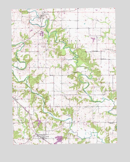
Monticello, MO USGS Topographic Map
Click on map above to begin viewing in our Map Viewer.

This topographic map contains these locations and features:
Feature Name Type Latitude Longitude GNIS ID View Map
Bancert CemeteryCemeteryN40.0695°W91.7421°713613View Map
Betsy BranchStreamN40.0464°W91.7193°732818View Map
Briscoe CemeteryCemeteryN40.0075°W91.6890°714718View Map
Cason CemeteryCemeteryN40.0348°W91.6957°715476View Map
City of EwingCivilN40.0087°W91.7147°2394716View Map
Cool Spring CemeteryCemeteryN40.0256°W91.6813°716231View Map
Cool SpringsSpringN40.0236°W91.6817°732819View Map
Cool Springs Church (historical)ChurchN40.0259°W91.6829°732820View Map
DurgenPopulated PlaceN40.0725°W91.6329°759832View Map
Durgens Creek Post OfficePost OfficeN40.0725°W91.6329°765605View Map
Durgens Creek Watershed Dam Number 28DamN40.0967°W91.6502°760506View Map
EwingPopulated PlaceN40.0062°W91.7138°735607View Map
Ewing DamDamN40.0200°W91.7168°760546View Map
Ewing LakeReservoirN40.0205°W91.7189°760547View Map
Ewing Post OfficePost OfficeN40.0059°W91.7141°2783147View Map
Finley CemeteryCemeteryN40.0900°W91.6679°717921View Map
Garnett CemeteryCemeteryN40.0886°W91.6632°718352View Map
GileadPopulated PlaceN40.0195°W91.6816°732821View Map
Gilead ChurchChurchN40.0192°W91.6818°735627View Map
Gilead SchoolSchoolN40.0178°W91.6821°732822View Map
Lewis CountyCivilN40.0969°W91.7221°758510View Map
Lewis County Sheriff's OfficeBuildingN40.1180°W91.7144°2752388View Map
Lloyd Wilson LakeReservoirN40.0962°W91.6520°760507View Map
MonticelloPopulated PlaceN40.1184°W91.7121°722546View Map
Monticello BridgeBridgeN40.1089°W91.7143°732823View Map
Monticello Post OfficePost OfficeN40.1189°W91.7140°2783093View Map
Monticello Volunteer Fire DepartmentBuildingN40.1174°W91.7137°2621227View Map
Nall CemeteryCemeteryN40.0717°W91.6910°723111View Map
Otter BranchStreamN40.0631°W91.7299°732824View Map
Pleasant Hill SchoolLocaleN40.0189°W91.6354°724558View Map
R - 4 Fire Protection District Station 1 HeadquartersBuildingN40.0064°W91.7158°2621545View Map
SellersPopulated PlaceN40.0664°W91.6735°741255View Map
Selton SchoolSchoolN40.0637°W91.7052°726196View Map
Steele BridgeBridgeN40.0198°W91.6796°732825View Map
Ten MilePopulated PlaceN40.0775°W91.6432°732826View Map
Ten Mile ChurchChurchN40.0850°W91.6482°727526View Map
Ten Mile SchoolSchoolN40.0778°W91.6427°727528View Map
TolonaPopulated PlaceN40.0431°W91.7485°735885View Map
Township of DickersonCivilN40.0999°W91.6999°766893View Map
Village of MonticelloCivilN40.1190°W91.7131°2399389View Map
Weston BridgeBridgeN40.0623°W91.6604°732827View Map

Note: Coordinates in the location and feature list above are referenced to NAD83 datum.


Copyright (C) 2008-2024 Ryan Niemi / Sunset Dynamics ... All Rights Reserved