TopoQuest Logo
Do you find TopoQuest useful?
Help keep TopoQuest running and adding new maps/features by donating!
Bitcoin:  19c7KJd3qBynnjoSw5npx9KScwjBe4ifkT
Litecoin:  LXs6TkuXGGXo1vDsWCkWVdjQX94eUKd6ui
Home View Maps Find Maps Find Places Resources & Links


Cantelous, Alabama Topographic Map

USGS Map Title: Cantelous, AL
USGS Map MRC: 32086C4
DRG (GeoTIFF) Download: o32086c4.tif


Neighboring USGS Topographic Map Quads:


  Forester, AL  
32086D5
 

  Prattville, AL  
32086D4
 

  Montgomery North, AL  
32086D3
 

  Lowndesboro, AL  
32086C5
 

  Cantelous, AL  
32086C4
 

  Montgomery South, AL  
32086C3
 

  Hayneville, AL  
32086B5
 

  Letohatchee, AL  
32086B4
 

  Snowdoun, AL  
32086B3


Map MRC Location:

N33°
W87°
N33°
W86°
H8 H7 H6 H5 H4 H3 H2 H1
G8 G7 G6 G5 G4 G3 G2 G1
F8 F7 F6 F5 F4 F3 F2 F1
E8 E7 E6 E5 E4 E3 E2 E1
D8 D7 D6 D5 D4 D3 D2 D1
C8 C7 C6 C5 C4 C3 C2 C1
B8 B7 B6 B5 B4 B3 B2 B1
A8 A7 A6 A5 A4 A3 A2 A1
N32°
W87°
N32°
W86°

Cantelous, AL USGS 1:24K Topographic Map Preview:
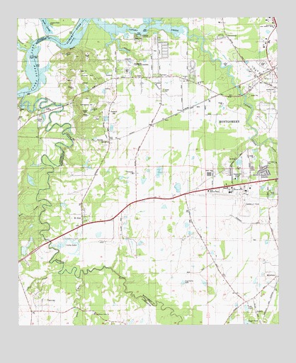
Cantelous, AL USGS Topographic Map
Click on map above to begin viewing in our Map Viewer.

This topographic map contains these locations and features:
Feature Name Type Latitude Longitude GNIS ID View Map
AntiochPopulated PlaceN32.3501°W86.4553°147687View Map
Antioch BranchStreamN32.3693°W86.4561°113102View Map
Antioch ChurchChurchN32.3501°W86.4530°113143View Map
Baggett DamDamN32.3101°W86.4400°130407View Map
Baggett LakeReservoirN32.3090°W86.4396°130408View Map
Bowling DamDamN32.2668°W86.4083°130364View Map
Brewer EstatesPopulated PlaceN32.3113°W86.3902°147725View Map
Burkville Volunteer Fire DepartmentBuildingN32.2644°W86.4968°2691573View Map
C D Long LakeReservoirN32.2885°W86.4866°130379View Map
C D Long Lake DamDamN32.2885°W86.4866°130378View Map
C H Warner DamDamN32.3285°W86.4533°130436View Map
Caney BranchStreamN32.3235°W86.3819°151718View Map
CantelousPopulated PlaceN32.3235°W86.4558°115591View Map
Cantelous CemeteryCemeteryN32.3365°W86.4536°115592View Map
Cantelous HillSummitN32.3390°W86.4650°115593View Map
Cantelous Lookout TowerTowerN32.3365°W86.4675°147737View Map
CatomaPopulated PlaceN32.3135°W86.4336°147753View Map
Catoma Baptist ChurchChurchN32.3487°W86.4130°154286View Map
Catoma CreekStreamN32.3743°W86.4622°151720View Map
Catoma Elementary SchoolSchoolN32.3118°W86.4444°115706View Map
Cedar PointPopulated PlaceN32.3668°W86.4400°147754View Map
Country EstatesPopulated PlaceN32.3535°W86.4155°142472View Map
D W Rutland DamDamN32.3468°W86.4716°130466View Map
Dannley PinesPopulated PlaceN32.3124°W86.3986°142489View Map
Davis CemeteryCemeteryN32.2610°W86.4861°117111View Map
Dry CreekStreamN32.2713°W86.4811°117562View Map
Dungee SchoolSchoolN32.3493°W86.4411°117667View Map
Durant BendBendN32.3626°W86.4766°142499View Map
Elgin DamDamN32.3068°W86.4216°130398View Map
Elgin LakeReservoirN32.3063°W86.4230°130399View Map
FairviewPopulated PlaceN32.3515°W86.4322°142521View Map
Fairview ChurchChurchN32.3515°W86.4308°118140View Map
Fairview United Methodist ChurchChurchN32.3512°W86.4308°155460View Map
Flowers DamDamN32.2868°W86.4916°130376View Map
Flowers LakeReservoirN32.2858°W86.4911°130377View Map
Graves BarBarN32.3474°W86.4919°147573View Map
GrovewoodPopulated PlaceN32.3674°W86.3994°142581View Map
Gunter HillSummitN32.3510°W86.4719°119502View Map
Hampton Hall Training CenterSchoolN32.3093°W86.3955°142590View Map
Hope Hull Recreation CenterBuildingN32.2685°W86.3766°142622View Map
Kendal CemeteryCemeteryN32.3462°W86.3769°121135View Map
Klondike Baptist ChurchChurchN32.3501°W86.4191°151966View Map
Lake BowlingReservoirN32.2672°W86.4108°130363View Map
Lake LindaReservoirN32.2567°W86.3907°121658View Map
Lee FarmsPopulated PlaceN32.3554°W86.3819°142666View Map
Longs LandingLocaleN32.3382°W86.4864°136385View Map
Lower Catoma BarBarN32.3710°W86.4691°142673View Map
Lucky LakesReservoirN32.2824°W86.4825°122103View Map
Manack BarBarN32.3546°W86.4939°147587View Map
Manacks Island (historical)IslandN32.3510°W86.4916°154279View Map
Montgomery International SpeedwayLocaleN32.3568°W86.4458°142715View Map
Montgomery Regional Airport (Dannelly Field)AirportN32.3025°W86.3907°129426View Map
Mount Moriah ChurchChurchN32.3174°W86.3952°152444View Map
Mount Olive Baptist ChurchChurchN32.3501°W86.3814°154225View Map
Mount SinaiPopulated PlaceN32.2940°W86.4683°142737View Map
Noland CreekStreamN32.3621°W86.4939°152698View Map
O'Possum Bight BarBarN32.3582°W86.4941°147602View Map
Pintlala CreekStreamN32.3432°W86.4972°152952View Map
Pleasant Valley ChurchChurchN32.2546°W86.4625°125045View Map
Rock CreekStreamN32.2988°W86.4883°125755View Map
Rutland LakeReservoirN32.3468°W86.4716°130467View Map
Saint Matts ChurchChurchN32.3301°W86.3805°142843View Map
SelbrookPopulated PlaceN32.3615°W86.4291°142854View Map
Selbrook ParkParkN32.3626°W86.4347°142855View Map
Sinai ChurchChurchN32.2907°W86.4705°153452View Map
Steep CreekStreamN32.2696°W86.4711°153562View Map
StonesPopulated PlaceN32.3374°W86.4208°142885View Map
Stones CemeteryCemeteryN32.3457°W86.4294°127435View Map
Stones ChapelChurchN32.3504°W86.4403°142886View Map
Sugarberry LakeReservoirN32.2674°W86.4211°142889View Map
Twin Gates EstatesPopulated PlaceN32.3121°W86.3819°142915View Map
Twin Gates ParkParkN32.3154°W86.3814°142916View Map
Warner LakeReservoirN32.3285°W86.4533°130435View Map
West Side Assembly of God ChurchChurchN32.3526°W86.3786°142940View Map

Note: Coordinates in the location and feature list above are referenced to NAD83 datum.


Copyright (C) 2008-2024 Ryan Niemi / Sunset Dynamics ... All Rights Reserved