TopoQuest Logo
Do you find TopoQuest useful?
Help keep TopoQuest running and adding new maps/features by donating!
Bitcoin:  19c7KJd3qBynnjoSw5npx9KScwjBe4ifkT
Litecoin:  LXs6TkuXGGXo1vDsWCkWVdjQX94eUKd6ui
Home View Maps Find Maps Find Places Resources & Links


Lowndesboro, Alabama Topographic Map

USGS Map Title: Lowndesboro, AL
USGS Map MRC: 32086C5
DRG (GeoTIFF) Download: o32086c5.tif


Neighboring USGS Topographic Map Quads:


  Autaugaville, AL  
32086D6
 

  Forester, AL  
32086D5
 

  Prattville, AL  
32086D4
 

  White Hall, AL  
32086C6
 

  Lowndesboro, AL  
32086C5
 

  Cantelous, AL  
32086C4
 

  Gordonsville, AL  
32086B6
 

  Hayneville, AL  
32086B5
 

  Letohatchee, AL  
32086B4


Map MRC Location:

N33°
W87°
N33°
W86°
H8 H7 H6 H5 H4 H3 H2 H1
G8 G7 G6 G5 G4 G3 G2 G1
F8 F7 F6 F5 F4 F3 F2 F1
E8 E7 E6 E5 E4 E3 E2 E1
D8 D7 D6 D5 D4 D3 D2 D1
C8 C7 C6 C5 C4 C3 C2 C1
B8 B7 B6 B5 B4 B3 B2 B1
A8 A7 A6 A5 A4 A3 A2 A1
N32°
W87°
N32°
W86°

Lowndesboro, AL USGS 1:24K Topographic Map Preview:
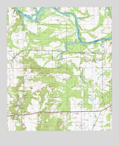
Lowndesboro, AL USGS Topographic Map
Click on map above to begin viewing in our Map Viewer.

This topographic map contains these locations and features:
Feature Name Type Latitude Longitude GNIS ID View Map
Alexander CemeteryCemeteryN32.3657°W86.6169°136311View Map
Bear CreekStreamN32.3682°W86.5883°113663View Map
Berry LakeLakeN32.3024°W86.5350°113965View Map
Bethel ChurchChurchN32.3249°W86.5414°136321View Map
Billdee CreekStreamN32.3632°W86.5416°114342View Map
Brown CemeteryCemeteryN32.3065°W86.5797°114983View Map
BurkvillePopulated PlaceN32.3282°W86.5369°156135View Map
Burkville Post OfficePost OfficeN32.3282°W86.5372°168211View Map
Camp ManackLocaleN32.3399°W86.5055°136331View Map
Canaan Hill ChurchChurchN32.2688°W86.5569°115527View Map
Christ ChurchChurchN32.2749°W86.5008°164188View Map
Deacon Hill Church (historical)ChurchN32.2599°W86.5583°136345View Map
Dickens PondReservoirN32.2597°W86.6129°136346View Map
Dry CreekStreamN32.2921°W86.5505°117535View Map
Fice CemeteryCemeteryN32.2654°W86.6122°118265View Map
Graves CemeteryCemeteryN32.3207°W86.5155°119271View Map
Haigler CemeteryCemeteryN32.2887°W86.5133°119545View Map
Huffman BarBarN32.3735°W86.5666°147578View Map
Lambert SchoolSchoolN32.2590°W86.5369°121358View Map
Lowndes AcademySchoolN32.2757°W86.6130°136386View Map
Lowndes County Sanitary LandfillLocaleN32.2599°W86.5836°136388View Map
LowndesboroPopulated PlaceN32.2751°W86.6114°163936View Map
Lowndesboro Post OfficePost OfficeN32.2815°W86.6098°168209View Map
Lowndesboro Volunteer Fire DepartmentBuildingN32.2755°W86.6127°2691574View Map
Lowndesport (historical)LocaleN32.3362°W86.5278°136389View Map
ManackPopulated PlaceN32.3285°W86.5111°152215View Map
Mcqueens DamDamN32.2818°W86.5200°130373View Map
McQueens PondReservoirN32.2819°W86.5212°136394View Map
Meadow CemeteryCemeteryN32.2935°W86.5969°122614View Map
Meadows Mill (historical)LocaleN32.2829°W86.6172°136396View Map
Mills (historical)LocaleN32.2688°W86.5672°136401View Map
Mount Canaan ChurchChurchN32.3229°W86.5586°152403View Map
Mount Olive ChurchChurchN32.2554°W86.5369°123297View Map
Newport BarBarN32.3654°W86.5983°147598View Map
Newport LandingLocaleN32.3601°W86.5903°136422View Map
Nichols DamDamN32.3701°W86.6233°130492View Map
Nichols LakeReservoirN32.3706°W86.6239°130491View Map
North Lowndes ChurchChurchN32.2904°W86.5111°136423View Map
Oakview CemeteryCemeteryN32.2851°W86.6047°124160View Map
Pine Grove CemeteryCemeteryN32.2662°W86.6122°136427View Map
Pleasant Hill SchoolSchoolN32.2993°W86.5105°125015View Map
Powell CemeteryCemeteryN32.3535°W86.6047°136431View Map
Powell CreekStreamN32.3574°W86.6053°125227View Map
Reese DamDamN32.3051°W86.5383°130395View Map
RobinsonsPopulated PlaceN32.3301°W86.5591°153171View Map
Rock Creek Baptist ChurchChurchN32.2779°W86.5019°136442View Map
Rock Creek SchoolSchoolN32.2771°W86.5014°125763View Map
Rocky BranchStreamN32.3729°W86.5644°125836View Map
Saint ClairPopulated PlaceN32.3235°W86.6166°126086View Map
Saint Clair Post OfficePost OfficeN32.3235°W86.6172°168210View Map
Saint Pauls ChurchChurchN32.2760°W86.6105°164189View Map
Stone CemeteryCemeteryN32.3201°W86.5230°127430View Map
Tallawassee BarBarN32.3510°W86.5397°147660View Map
Tallawassee CreekStreamN32.3390°W86.5366°164133View Map
Tensaw CreekStreamN32.3665°W86.6047°127763View Map
Town of LowndesboroCivilN32.2764°W86.6108°2406051View Map
Turner CemeteryCemeteryN32.2871°W86.6033°128191View Map
Union ChurchChurchN32.3215°W86.5197°128291View Map
Union School (historical)SchoolN32.2818°W86.5658°136468View Map
Varners Store (historical)LocaleN32.2743°W86.5022°136471View Map
Wooten CemeteryCemeteryN32.3082°W86.5791°164150View Map
Yankee Town CemeteryCemeteryN32.3204°W86.5280°129270View Map
York LakeReservoirN32.2801°W86.5283°130371View Map
York Number 2 DamDamN32.2801°W86.5283°130372View Map
Young CemeteryCemeteryN32.2985°W86.5361°129310View Map

Note: Coordinates in the location and feature list above are referenced to NAD83 datum.


Copyright (C) 2008-2025 Ryan Niemi / Sunset Dynamics ... All Rights Reserved