TopoQuest Logo
Do you find TopoQuest useful?
Help keep TopoQuest running and adding new maps/features by donating!
Bitcoin:  19c7KJd3qBynnjoSw5npx9KScwjBe4ifkT
Litecoin:  LXs6TkuXGGXo1vDsWCkWVdjQX94eUKd6ui
Home View Maps Find Maps Find Places Resources & Links


Hayneville, Alabama Topographic Map

USGS Map Title: Hayneville, AL
USGS Map MRC: 32086B5
DRG (GeoTIFF) Download: o32086b5.tif


Neighboring USGS Topographic Map Quads:


  White Hall, AL  
32086C6
 

  Lowndesboro, AL  
32086C5
 

  Cantelous, AL  
32086C4
 

  Gordonsville, AL  
32086B6
 

  Hayneville, AL  
32086B5
 

  Letohatchee, AL  
32086B4
 

  Mount Willing, AL  
32086A6
 

  Calhoun, AL  
32086A5
 

  Sandy Ridge, AL  
32086A4


Map MRC Location:

N33°
W87°
N33°
W86°
H8 H7 H6 H5 H4 H3 H2 H1
G8 G7 G6 G5 G4 G3 G2 G1
F8 F7 F6 F5 F4 F3 F2 F1
E8 E7 E6 E5 E4 E3 E2 E1
D8 D7 D6 D5 D4 D3 D2 D1
C8 C7 C6 C5 C4 C3 C2 C1
B8 B7 B6 B5 B4 B3 B2 B1
A8 A7 A6 A5 A4 A3 A2 A1
N32°
W87°
N32°
W86°

Hayneville, AL USGS 1:24K Topographic Map Preview:
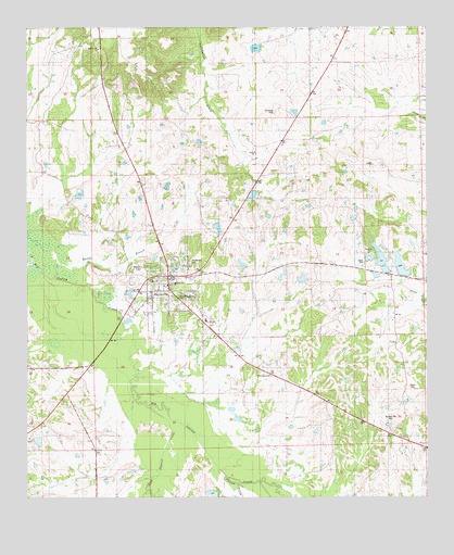
Hayneville, AL USGS Topographic Map
Click on map above to begin viewing in our Map Viewer.

This topographic map contains these locations and features:
Feature Name Type Latitude Longitude GNIS ID View Map
Baptist Hill ChurchChurchN32.2443°W86.6025°136314View Map
Bricefield Church (historical)ChurchN32.1843°W86.6247°136329View Map
Bullock Hill CemeteryCemeteryN32.1454°W86.5114°136330View Map
Cherry CreekStreamN32.1279°W86.5491°116007View Map
Coopers PondReservoirN32.2056°W86.6082°136338View Map
Crenshaw PondReservoirN32.2275°W86.5410°136340View Map
Crenshaws Pond Number TwoReservoirN32.2053°W86.5543°130289View Map
Davis CemeteryCemeteryN32.1874°W86.5197°136477View Map
Fort Deposit CreekStreamN32.1496°W86.5875°118519View Map
Friendship ChurchChurchN32.1576°W86.5494°136355View Map
Grant DamDamN32.1818°W86.5383°130246View Map
Grant LakeReservoirN32.1831°W86.5389°130245View Map
Harrell LakeReservoirN32.1867°W86.5082°154123View Map
Harrells Lake OneReservoirN32.1892°W86.5148°130253View Map
HaynevillePopulated PlaceN32.1840°W86.5803°119902View Map
Hayneville CemeteryCemeteryN32.1876°W86.5741°136368View Map
Hayneville High SchoolSchoolN32.1818°W86.5789°136369View Map
Hayneville Post OfficePost OfficeN32.1843°W86.5787°168204View Map
Hayneville Volunteer Fire DepartmentBuildingN32.1836°W86.5792°2691153View Map
J L Crenshaw Number 2 DamDamN32.2051°W86.5533°130288View Map
Lake CreekStreamN32.1471°W86.5772°121316View Map
Lowndes County CourthouseBuildingN32.1835°W86.5794°168205View Map
Lowndes County Sheriff's OfficeBuildingN32.1837°W86.5798°2751824View Map
McQueen CemeteryCemeteryN32.2274°W86.5469°136393View Map
Mount Olive ChurchChurchN32.1410°W86.6244°163495View Map
Mount Sinai ChurchChurchN32.1899°W86.5264°136416View Map
Mushat Gilchrist CemeteryCemeteryN32.1779°W86.5775°136419View Map
Neil Robinson DamDamN32.2468°W86.5533°130341View Map
Possum CreekStreamN32.1307°W86.5628°136430View Map
Powell Station (historical)LocaleN32.1838°W86.5094°136432View Map
Prairie Hill Post Office (historical)Post OfficeN32.1426°W86.6241°166061View Map
Robinsons LakeReservoirN32.2468°W86.5533°130342View Map
Russell SchoolSchoolN32.1718°W86.5691°136447View Map
Town of HaynevilleCivilN32.1821°W86.5787°2405810View Map
W B Woodall LakeReservoirN32.2035°W86.5666°130285View Map
W B Woodall Lake DamDamN32.2035°W86.5666°130286View Map
Wynn and Harrell Number 1 DamDamN32.1868°W86.5133°130252View Map
Wynn and Harrell Number 2 DamDamN32.1851°W86.5066°130249View Map
Wynn and Harrell PondReservoirN32.1856°W86.5128°129261View Map

Note: Coordinates in the location and feature list above are referenced to NAD83 datum.


Copyright (C) 2008-2024 Ryan Niemi / Sunset Dynamics ... All Rights Reserved