TopoQuest Logo
Do you find TopoQuest useful?
Help keep TopoQuest running and adding new maps/features by donating!
Bitcoin:  19c7KJd3qBynnjoSw5npx9KScwjBe4ifkT
Litecoin:  LXs6TkuXGGXo1vDsWCkWVdjQX94eUKd6ui
Home View Maps Find Maps Find Places Resources & Links


Ragged Mountain, Maine Topographic Map

USGS Map Title: Ragged Mountain, ME
USGS Map MRC: 45068E8
DRG (GeoTIFF) Download: o45068e8.tif


Neighboring USGS Topographic Map Quads:


  Nahmakanta Stream, ME  
45069F1
 

  Pemadumcook Lake, ME  
45068F8
 

  Norcross, ME  
45068F7
 

  Jo-Mary Mountain, ME  
45069E1
 

  Ragged Mountain, ME  
45068E8
 

  Cedar Lake, ME  
45068E7
 

  Ebeemee Mountain, ME  
45069D1
 

  Seboeis Lake, ME  
45068D8
 

  Endless Lake, ME  
45068D7


Map MRC Location:

N46°
W69°
N46°
W68°
H8 H7 H6 H5 H4 H3 H2 H1
G8 G7 G6 G5 G4 G3 G2 G1
F8 F7 F6 F5 F4 F3 F2 F1
E8 E7 E6 E5 E4 E3 E2 E1
D8 D7 D6 D5 D4 D3 D2 D1
C8 C7 C6 C5 C4 C3 C2 C1
B8 B7 B6 B5 B4 B3 B2 B1
A8 A7 A6 A5 A4 A3 A2 A1
N45°
W69°
N45°
W68°

Ragged Mountain, ME USGS 1:24K Topographic Map Preview:
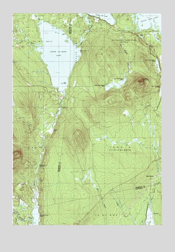
Ragged Mountain, ME USGS Topographic Map
Click on map above to begin viewing in our Map Viewer.

This topographic map contains these locations and features:
Feature Name Type Latitude Longitude GNIS ID View Map
Balancing RockIslandN45.6031°W68.9442°561490View Map
Black IslandIslandN45.5831°W68.9589°562450View Map
Duck BrookStreamN45.6173°W68.9789°565330View Map
East Ragged BrookStreamN45.6181°W68.8809°565671View Map
Jo-Mary TrailTrailN45.5150°W68.9709°568858View Map
Johnston BrookStreamN45.6048°W68.9759°568939View Map
Lost PondLakeN45.6111°W68.8919°570409View Map
Lower East Ragged PondLakeN45.5944°W68.8778°570494View Map
Lower West Ragged PondLakeN45.5836°W68.9083°570557View Map
Ragged MountainSummitN45.5845°W68.8925°573968View Map
Sanborn BrookStreamN45.5787°W68.9575°574810View Map
Sanborn PondLakeN45.5562°W68.9663°574817View Map
Sandy BrookStreamN45.6100°W68.8792°574872View Map
The InletLakeN45.5050°W68.8859°576835View Map
Upper Ebeemee LakeLakeN45.5009°W68.9806°577600View Map
Upper Jo-Mary LakeReservoirN45.6008°W68.9617°577620View Map
Upper Jo-Mary StreamStreamN45.6242°W68.9362°577621View Map
Upper West Ragged PondLakeN45.5817°W68.9184°577673View Map
Veazie GoreCivilN45.5980°W68.9447°1987354View Map
Wangan BrookStreamN45.5098°W68.9800°577820View Map
Wangan Brook DeadwaterLakeN45.5341°W68.9786°577821View Map
West Ragged BrookStreamN45.6142°W68.8928°578210View Map
West SeboeisPopulated PlaceN45.5292°W68.8787°578221View Map
West Seboeis StreamStreamN45.5084°W68.8842°578222View Map

Note: Coordinates in the location and feature list above are referenced to NAD83 datum.


Copyright (C) 2008-2025 Ryan Niemi / Sunset Dynamics ... All Rights Reserved