TopoQuest Logo
Do you find TopoQuest useful?
Help keep TopoQuest running and adding new maps/features by donating!
Bitcoin:  19c7KJd3qBynnjoSw5npx9KScwjBe4ifkT
Litecoin:  LXs6TkuXGGXo1vDsWCkWVdjQX94eUKd6ui
Home View Maps Find Maps Find Places Resources & Links


Raton, New Mexico Topographic Map

USGS Map Title: Raton, NM
USGS Map MRC: 36104H4
DRG (GeoTIFF) Download: o36104h4.tif


Neighboring USGS Topographic Map Quads:


  Starkville, CO  
37104A5
 

  Fishers Peak, CO  
37104A4
 

  Barela, CO  
37104A3
 

  Tin Pan Canyon, NM  
36104H5
 

  Raton, NM  
36104H4
 

  Yankee, NM  
36104H3
 

  Red River Peak, NM  
36104G5
 

  Clifton House, NM  
36104G4
 

  Hunter Mesa, NM  
36104G3


Map MRC Location:

N37°
W105°
N37°
W104°
H8 H7 H6 H5 H4 H3 H2 H1
G8 G7 G6 G5 G4 G3 G2 G1
F8 F7 F6 F5 F4 F3 F2 F1
E8 E7 E6 E5 E4 E3 E2 E1
D8 D7 D6 D5 D4 D3 D2 D1
C8 C7 C6 C5 C4 C3 C2 C1
B8 B7 B6 B5 B4 B3 B2 B1
A8 A7 A6 A5 A4 A3 A2 A1
N36°
W105°
N36°
W104°

Raton, NM USGS 1:24K Topographic Map Preview:
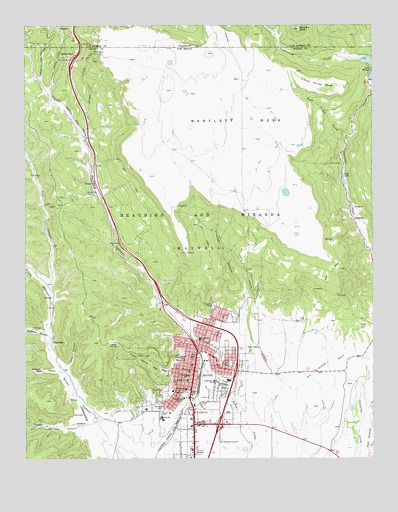
Raton, NM USGS Topographic Map
Click on map above to begin viewing in our Map Viewer.

This topographic map contains these locations and features:
Feature Name Type Latitude Longitude GNIS ID View Map
Arthur Johnson Memorial LibraryBuildingN36.9034°W104.4392°929411View Map
Bartlett MesaSummitN36.9920°W104.4347°203746View Map
BlossburgLocaleN36.9092°W104.4908°886504View Map
Blossburg Number One MineMineN36.9186°W104.4922°939877View Map
Blossburg Number ThreeMineN36.9209°W104.4980°916520View Map
Blossburg Number Two MineMineN36.9186°W104.4922°939878View Map
Blossburg Post Office (historical)Post OfficeN36.9092°W104.4908°937424View Map
Bobblers KnobSummitN36.9989°W104.4017°194976View Map
City of RatonCivilN36.8850°W104.4396°2411522View Map
Climax Canyon ParkParkN36.9034°W104.4572°887690View Map
Climax MineMineN36.9061°W104.4664°939786View Map
Coal CanyonStreamN36.9266°W104.4907°194968View Map
Colfax County Sheriff's DepartmentBuildingN36.8756°W104.4392°2722492View Map
Columbian SchoolSchoolN36.9095°W104.4380°887751View Map
Coxe CanyonValleyN36.9022°W104.4847°888009View Map
Dillon CanyonValleyN36.8817°W104.4672°905766View Map
Dona Ana Plaza SouthLocaleN36.8828°W104.4392°901101View Map
Dutchman CanyonValleyN36.9111°W104.4933°888599View Map
Fairmont CemeteryCemeteryN36.9054°W104.4300°888951View Map
Fred Roth BuildingBuildingN36.9034°W104.4392°935878View Map
GardinerPopulated PlaceN36.8853°W104.4825°899645View Map
Gardiner CanyonValleyN36.8842°W104.4808°889345View Map
Gardiner Number One MineMineN36.9061°W104.4664°939874View Map
Gardiner Post Office (historical)Post OfficeN36.8853°W104.4825°938251View Map
Goat HillSummitN36.9042°W104.4450°889452View Map
Haven Hotel Historic SiteBuildingN36.9034°W104.4392°933772View Map
Investment BlockLocaleN36.9033°W104.4386°935834View Map
Joseph Building Historic SiteBuildingN36.9034°W104.4392°935205View Map
Kearney SchoolSchoolN36.8950°W104.4428°890634View Map
Kearny Elementary SchoolSchoolN36.9034°W104.4392°933826View Map
KeotaPopulated PlaceN36.9545°W104.4764°899692View Map
KRTN-AM (Raton)TowerN36.8861°W104.4436°938609View Map
KRTN-FM (Raton)TowerN36.8856°W104.4430°938687View Map
Lake AliceReservoirN36.9554°W104.3859°885679View Map
Lake Alice DamDamN36.9500°W104.3839°924114View Map
Legion ParkParkN36.8942°W104.4417°891037View Map
Linwood CanyonValleyN36.9156°W104.4225°891098View Map
Little Horse MesaRidgeN36.9825°W104.3955°891144View Map
Longfellow Elementary SchoolSchoolN36.9034°W104.4392°933889View Map
Longfellow SchoolSchoolN36.8972°W104.4328°891314View Map
Lynn (historical)LocaleN36.9864°W104.4986°932922View Map
Lynn Post Office (historical)Post OfficeN36.9864°W104.4986°938362View Map
Miners HospitalHospitalN36.8945°W104.4475°892100View Map
Mount Calvary Catholic CemeteryCemeteryN36.8900°W104.4524°892267View Map
New York and Golden Rule StoresBuildingN36.9033°W104.4386°935780View Map
Northern Colfax County Hospital LibraryBuildingN36.9034°W104.4392°929346View Map
Palace HotelBuildingN36.9034°W104.4392°935435View Map
Ragsdale FieldParkN36.8914°W104.4439°893608View Map
Railroad CanyonValleyN36.9118°W104.4410°893614View Map
RatonPopulated PlaceN36.9034°W104.4392°902335View Map
Raton Catholic SchoolSchoolN36.9034°W104.4392°934185View Map
Raton City Police DepartmentBuildingN36.9051°W104.4399°2722527View Map
Raton Downtown Historic DistrictLocaleN36.9034°W104.4392°934422View Map
Raton Fire and Emergency ServicesBuildingN36.9031°W104.4390°2657726View Map
Raton High SchoolSchoolN36.8869°W104.4520°901445View Map
Raton Historical MarkerParkN36.9034°W104.4392°932384View Map
Raton Middle SchoolSchoolN36.9200°W104.4392°901446View Map
Raton MuseumBuildingN36.9034°W104.4392°929510View Map
Raton PassGapN36.9911°W104.4867°898411View Map
Raton Pass Historical MarkerParkN36.9034°W104.4392°932303View Map
Raton Post OfficePost OfficeN36.9021°W104.4405°937903View Map
Raton TunnelTunnelN36.9903°W104.4886°893673View Map
Raton Water WorksLocaleN36.9034°W104.4392°936010View Map
Raton Weather StationLocaleN36.9834°W104.3839°932557View Map
Raton Weather StationLocaleN36.9034°W104.4392°932559View Map
Ripley ParkParkN36.9050°W104.4383°893969View Map
Rocky Mountains Historical MarkerParkN36.9034°W104.4392°932302View Map
Romero ParkParkN36.9025°W104.4267°894141View Map
Saint Patricks SchoolSchoolN36.8989°W104.4419°894289View Map
Savage CanyonValleyN36.9695°W104.4778°894607View Map
Second Presbyterian ChurchChurchN36.9011°W104.4331°902502View Map
Seeley CanyonValleyN36.9003°W104.4892°894702View Map
Segerstrom CreekStreamN36.9903°W104.3792°194878View Map
Seventh Day AdventistChurchN36.9034°W104.4392°920481View Map
Shuler TheaterBuildingN36.9034°W104.4392°935939View Map
Soda Pocket CreekStreamN36.9675°W104.3842°894984View Map
SugaritePopulated PlaceN36.9439°W104.3819°899930View Map
Sugarite Canyon State ParkParkN36.9442°W104.3817°902662View Map
Sugarite Number One MineMineN36.9475°W104.3792°939787View Map
Sugarite Number Two MineMineN36.9475°W104.3792°939875View Map
Sugarite Post Office (historical)Post OfficeN36.9439°W104.3819°937755View Map
Van BuskirkLocaleN36.8859°W104.3805°924625View Map
WoottonLocaleN36.9992°W104.4878°194975View Map

Note: Coordinates in the location and feature list above are referenced to NAD83 datum.


Copyright (C) 2008-2024 Ryan Niemi / Sunset Dynamics ... All Rights Reserved