TopoQuest Logo
Do you find TopoQuest useful?
Help keep TopoQuest running and adding new maps/features by donating!
Bitcoin:  19c7KJd3qBynnjoSw5npx9KScwjBe4ifkT
Litecoin:  LXs6TkuXGGXo1vDsWCkWVdjQX94eUKd6ui
Home View Maps Find Maps Find Places Resources & Links


Savage, Montana Topographic Map

USGS Map Title: Savage, MT
USGS Map MRC: 47104D3
DRG (GeoTIFF) Download: o47104d3.tif


Neighboring USGS Topographic Map Quads:


  Larson School, MT  
47104E4
 

  Crane, MT  
47104E3
 

  Piche, MT  
47104E2
 

  Knife River Mine, MT  
47104D4
 

  Savage, MT  
47104D3
 

  Skaar NW, MT  
47104D2
 

  Savage SW, MT  
47104C4
 

  Savage SE, MT  
47104C3
 

  Parson Creek, MT  
47104C2


Map MRC Location:

N48°
W105°
N48°
W104°
H8 H7 H6 H5 H4 H3 H2 H1
G8 G7 G6 G5 G4 G3 G2 G1
F8 F7 F6 F5 F4 F3 F2 F1
E8 E7 E6 E5 E4 E3 E2 E1
D8 D7 D6 D5 D4 D3 D2 D1
C8 C7 C6 C5 C4 C3 C2 C1
B8 B7 B6 B5 B4 B3 B2 B1
A8 A7 A6 A5 A4 A3 A2 A1
N47°
W105°
N47°
W104°

Savage, MT USGS 1:24K Topographic Map Preview:
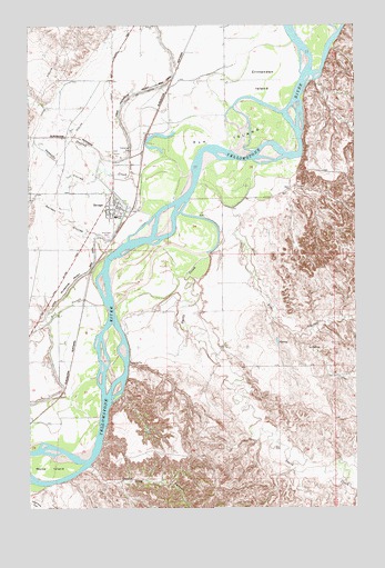
Savage, MT USGS Topographic Map
Click on map above to begin viewing in our Map Viewer.

This topographic map contains these locations and features:
Feature Name Type Latitude Longitude GNIS ID View Map
19N58E02DBBB01 WellWellN47.4328°W104.2897°822881View Map
19N58E04DDC_01 WellWellN47.4267°W104.3272°822837View Map
19N58E04DDCA01 WellWellN47.4295°W104.3261°822858View Map
19N58E05BA__01 WellWellN47.4397°W104.3569°822937View Map
19N58E05CD__01 WellWellN47.4286°W104.3569°822850View Map
19N58E07AADA01 WellWellN47.4247°W104.3644°822825View Map
19N58E08AD__01 WellWellN47.4214°W104.3463°822806View Map
19N58E08BC__01 WellWellN47.4214°W104.3622°822807View Map
19N58E18AD__01 WellWellN47.4064°W104.3674°822708View Map
19N58E18DB__01 WellWellN47.4028°W104.3727°822685View Map
19N58E18DC__01 WellWellN47.3992°W104.3727°822665View Map
20N58E14AA__01 WellWellN47.4983°W104.2827°823403View Map
20N58E14BB__01 WellWellN47.4983°W104.2986°823404View Map
20N58E15AD__01 WellWellN47.4947°W104.3038°823384View Map
20N58E15CD__01 WellWellN47.4875°W104.3144°823350View Map
20N58E15CD__02 WellWellN47.4983°W104.3358°823405View Map
20N58E16BA__01 WellWellN47.4983°W104.3411°823406View Map
20N58E16BB__01 WellWellN47.4947°W104.3411°823386View Map
20N58E16BC__01 WellWellN47.4947°W104.3358°823385View Map
20N58E16BD__01 WellWellN47.4875°W104.3463°823351View Map
20N58E17DD__01 WellWellN47.4875°W104.3677°823352View Map
20N58E18DD__01 WellWellN47.4800°W104.3677°823298View Map
20N58E19AD__01 WellWellN47.4836°W104.3463°823321View Map
20N58E20AA__01 WellWellN47.4836°W104.3516°823322View Map
20N58E20AB__01 WellWellN47.4764°W104.3569°823268View Map
20N58E20CA__01 WellWellN47.4728°W104.3463°823244View Map
20N58E20DD__01 WellWellN47.4800°W104.3252°823297View Map
20N58E21AD__01 WellWellN47.4836°W104.3411°823320View Map
20N58E21BB__01 WellWellN47.4764°W104.3038°823267View Map
20N58E22DA__01 WellWellN47.4692°W104.3358°823196View Map
20N58E24ABAA01 WellWellN47.4845°W104.2647°823327View Map
20N58E25CCAC01 WellWellN47.4578°W104.2758°823087View Map
20N58E28BA__01 WellWellN47.4656°W104.3358°823173View Map
20N58E28BD__01 WellWellN47.4692°W104.3463°823197View Map
20N58E29AA__01 WellWellN47.4583°W104.3569°823096View Map
20N58E29CBC_01 WellWellN47.4603°W104.3622°823122View Map
20N58E29CD__01 WellWellN47.4620°W104.3516°823131View Map
20N58E29DB__01 WellWellN47.4583°W104.3516°823095View Map
20N58E29DC__01 WellWellN47.4583°W104.3463°823094View Map
20N58E29DD__01 WellWellN47.4620°W104.3730°823132View Map
20N58E30DB__01 WellWellN47.4547°W104.3463°823059View Map
20N58E32AA__01 WellWellN47.4547°W104.3516°823060View Map
20N58E32AC__01 WellWellN47.4511°W104.3516°823017View Map
20N58E32AC__02 WellWellN47.4511°W104.3463°823016View Map
20N58E32AD__01 WellWellN47.4547°W104.3622°823061View Map
20N58E32BB__02 WellWellN47.4547°W104.3622°823062View Map
20N58E32DD__01 WellWellN47.4439°W104.3463°822962View Map
20N58E33BA__01 WellWellN47.4547°W104.3358°823055View Map
20N58E33BA__02 WellWellN47.4547°W104.3358°823056View Map
20N58E33BA__03 WellWellN47.4547°W104.3358°823057View Map
20N58E33BB__01 WellWellN47.4547°W104.3411°823058View Map
20N58E33BC__01 WellWellN47.4511°W104.3411°823015View Map
20N58E33CB__01 WellWellN47.4475°W104.3411°822980View Map
20N58E34DDD_01 WellWellN47.4420°W104.3016°822952View Map
20N58E35BC__01 WellWellN47.4511°W104.2986°823014View Map
21N58E08DDAD01 WellWellN47.4222°W104.2938°822810View Map
Beaver IslandIslandN47.4347°W104.3366°1714954View Map
Beef SloughStreamN47.4278°W104.3466°768664View Map
Brasseaus Houses (historical)LocaleN47.4347°W104.3519°1715002View Map
Breakneck IslandIslandN47.4464°W104.3113°1715258View Map
Cecil Junction (historical)LocaleN47.4931°W104.3158°1714997View Map
Crittenden IslandIslandN47.4875°W104.2838°770303View Map
Devils CanyonValleyN47.3856°W104.3530°770619View Map
Devils IslandIslandN47.4411°W104.3338°1714955View Map
Duck IslandIslandN47.4156°W104.3430°1714953View Map
Dundee Post Office (historical)Post OfficeN47.4895°W104.3088°1714992View Map
Dunlap CreekStreamN47.4625°W104.3133°770908View Map
Elk IslandIslandN47.4703°W104.3061°771193View Map
Elk Island Fishing Access SiteLocaleN47.4689°W104.3138°1744330View Map
Elm CouleeValleyN47.4297°W104.2877°771207View Map
Elm Coulee School (historical)SchoolN47.4261°W104.3011°1715230View Map
Elms IslandIslandN47.4036°W104.3519°1714952View Map
First Congregational ChurchChurchN47.4536°W104.3422°1715293View Map
First Lutheran Church of SavageChurchN47.4514°W104.3441°1715266View Map
Garden CouleeValleyN47.4411°W104.3441°771701View Map
Knife RiverPopulated PlaceN47.4528°W104.3433°1853183View Map
Marys IslandIslandN47.3858°W104.3694°773913View Map
Peabody CouleeValleyN47.4625°W104.3469°775120View Map
Richland County Ambulance SavageBuildingN47.4532°W104.3410°2637898View Map
Riverview CemeteryCemeteryN47.4453°W104.3449°775798View Map
Saint Michaels Catholic ChurchChurchN47.4525°W104.3424°1715267View Map
SavageLocaleN47.4520°W104.3361°1714940View Map
SavagePopulated PlaceN47.4536°W104.3427°776236View Map
Savage Census Designated PlaceCensusN47.4536°W104.3413°2408495View Map
Savage MuseumBuildingN47.4533°W104.3413°1715022View Map
Savage Post OfficePost OfficeN47.4531°W104.3424°1714941View Map
Savage Public SchoolSchoolN47.4506°W104.3422°1715246View Map
Savage Volunteer Fire CompanyBuildingN47.4532°W104.3411°1715023View Map
Smith CreekStreamN47.4411°W104.3069°776674View Map
Tokna Post Office (historical)Post OfficeN47.4931°W104.3316°1714957View Map
Yellowstone Community ChurchChurchN47.4525°W104.3433°1715268View Map

Note: Coordinates in the location and feature list above are referenced to NAD83 datum.


Copyright (C) 2008-2025 Ryan Niemi / Sunset Dynamics ... All Rights Reserved