TopoQuest Logo
Do you find TopoQuest useful?
Help keep TopoQuest running and adding new maps/features by donating!
Bitcoin:  19c7KJd3qBynnjoSw5npx9KScwjBe4ifkT
Litecoin:  LXs6TkuXGGXo1vDsWCkWVdjQX94eUKd6ui
Home View Maps Find Maps Find Places Resources & Links


Cape San Martin, California Topographic Map

USGS Map Title: Cape San Martin, CA
USGS Map MRC: 35121H4
DRG (GeoTIFF) Download: o35121h4.tif


Neighboring USGS Topographic Map Quads:


  Lopez Point, CA  
36121A5
 

  Cone Peak, CA  
36121A4
 

  Bear Canyon, CA  
36121A3


  Cape San Martin, CA  
35121H4
 

  Alder Peak, CA  
35121H3


  Villa Creek, CA  
35121G4
 

  Burro Mountain, CA  
35121G3


Map MRC Location:

N36°
W122°
N36°
W121°
H8 H7 H6 H5 H4 H3 H2 H1
G8 G7 G6 G5 G4 G3 G2 G1
F8 F7 F6 F5 F4 F3 F2 F1
E8 E7 E6 E5 E4 E3 E2 E1
D8 D7 D6 D5 D4 D3 D2 D1
C8 C7 C6 C5 C4 C3 C2 C1
B8 B7 B6 B5 B4 B3 B2 B1
A8 A7 A6 A5 A4 A3 A2 A1
N35°
W122°
N35°
W121°

Cape San Martin, CA USGS 1:24K Topographic Map Preview:
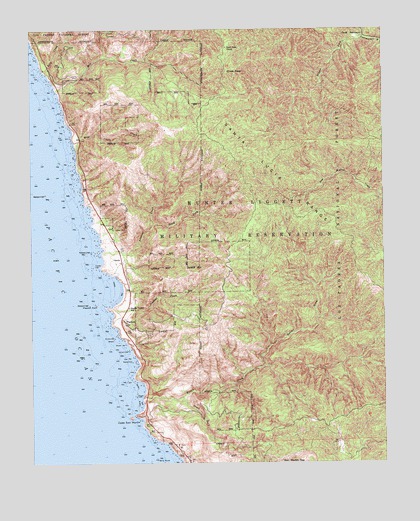
Cape San Martin, CA USGS Topographic Map
Click on map above to begin viewing in our Map Viewer.

This topographic map contains these locations and features:
Feature Name Type Latitude Longitude GNIS ID View Map
Alder Creek CampgroundLocaleN35.8761°W121.3852°275467View Map
Alms CampgroundLocaleN35.9844°W121.4669°1655275View Map
Alms CampgroundLocaleN35.9858°W121.4674°275480View Map
Apple CampgroundLocaleN35.9780°W121.4372°276032View Map
Apple CampgroundLocaleN35.9786°W121.4372°275476View Map
Big Sur Volunteer Fire Brigade Station 3BuildingN35.9352°W121.4687°2623967View Map
Bird RockIslandN35.8752°W121.4527°269866View Map
Buclimo MineMineN35.8830°W121.3952°275466View Map
Camp NacimientoLocaleN35.9980°W121.3838°270209View Map
Cape San MartinCapeN35.8889°W121.4630°273504View Map
Chalk PeakSummitN35.9886°W121.4269°1660468View Map
Chalk Peak CampLocaleN35.9947°W121.4305°270385View Map
GordaPopulated PlaceN35.9325°W121.4688°271364View Map
Gorda MineMineN35.8769°W121.4310°1666378View Map
Gorda School (historical)SchoolN35.9269°W121.4666°1666379View Map
Jade CoveBayN35.9036°W121.4638°1703254View Map
Kirk CreekStreamN35.9880°W121.4958°244334View Map
Kirk Creek CampgroundLocaleN35.9888°W121.4958°1703253View Map
Krenkels Ranch (historical)LocaleN35.8777°W121.3922°1666381View Map
Melville MineMineN35.8872°W121.4005°1666383View Map
Melville MineMineN35.8858°W121.3883°275465View Map
Miguel CampgroundLocaleN35.9369°W121.3924°276018View Map
Miguel CampgroundLocaleN35.9455°W121.3922°275471View Map
Mill CreekStreamN35.9827°W121.4919°272464View Map
Mill Creek CampgroundLocaleN35.9819°W121.4891°276031View Map
Mill Creek CampgroundLocaleN35.9822°W121.4897°275479View Map
Mill Creek Picnic AreaLocaleN35.9825°W121.4913°1703257View Map
Negro Fork Nacimiento RiverStreamN35.9975°W121.3816°1655152View Map
North Fork Willow CreekStreamN35.9027°W121.4183°272707View Map
Pacific Valley K - 12 SchoolSchoolN35.9198°W121.4660°272829View Map
PlaskettPopulated PlaceN35.9166°W121.4688°1661240View Map
Plaskett CreekStreamN35.9200°W121.4722°273050View Map
Plaskett Creek CampgroundLocaleN35.9205°W121.4655°276039View Map
Plaskett Creek CampgroundLocaleN35.9205°W121.4649°275473View Map
Plaskett RockIslandN35.9208°W121.4780°273051View Map
Prewitt CreekStreamN35.9352°W121.4755°273123View Map
Prewitt Ridge CampgroundLocaleN35.9702°W121.4510°276033View Map
Prewitt Ridge CampgroundLocaleN35.9705°W121.4508°275477View Map
San Martin RockIslandN35.8880°W121.4660°253323View Map
San Martin TopSummitN35.8783°W121.4019°273505View Map
Sand Dollar BeachBeachN35.9239°W121.4685°1703268View Map
Sand Dollar Picnic AreaLocaleN35.9208°W121.4669°275474View Map
South Fork Prewitt CreekStreamN35.9441°W121.4566°273833View Map
South Fork Willow CreekStreamN35.8939°W121.4477°273844View Map
Stag Rustic CampsiteLocaleN35.9652°W121.4608°276037View Map
Sycamore Flat CampgroundLocaleN35.8958°W121.4369°275475View Map
Tide RockBarN35.9511°W121.4935°253324View Map
White Valley CampgroundLocaleN35.9347°W121.4672°276038View Map
White Valley CampgroundLocaleN35.9347°W121.4674°275472View Map
Wild Cattle CreekStreamN35.9675°W121.4855°1667937View Map
Willow CreekStreamN35.8939°W121.4616°251615View Map
Willow Creek Picnic AreaLocaleN35.8936°W121.4597°275499View Map
Willow PeakSummitN35.9216°W121.3966°253325View Map

Note: Coordinates in the location and feature list above are referenced to NAD83 datum.


Copyright (C) 2008-2025 Ryan Niemi / Sunset Dynamics ... All Rights Reserved