TopoQuest Logo
Do you find TopoQuest useful?
Help keep TopoQuest running and adding new maps/features by donating!
Bitcoin:  19c7KJd3qBynnjoSw5npx9KScwjBe4ifkT
Litecoin:  LXs6TkuXGGXo1vDsWCkWVdjQX94eUKd6ui
Home View Maps Find Maps Find Places Resources & Links


Thistle, Utah Topographic Map

USGS Map Title: Thistle, UT
USGS Map MRC: 39111H4
DRG (GeoTIFF) Download: o39111h4.tif


Neighboring USGS Topographic Map Quads:


  Spanish Fork Peak, UT  
40111A5
 

  Billies Mountain, UT  
40111A4
 

  Rays Valley, UT  
40111A3
 

  Birdseye, UT  
39111H5
 

  Thistle, UT  
39111H4
 

  Mill Fork, UT  
39111H3
 

  Spencer Canyon, UT  
39111G5
 

  Indianola, UT  
39111G4
 

  C Canyon, UT  
39111G3


Map MRC Location:

N40°
W112°
N40°
W111°
H8 H7 H6 H5 H4 H3 H2 H1
G8 G7 G6 G5 G4 G3 G2 G1
F8 F7 F6 F5 F4 F3 F2 F1
E8 E7 E6 E5 E4 E3 E2 E1
D8 D7 D6 D5 D4 D3 D2 D1
C8 C7 C6 C5 C4 C3 C2 C1
B8 B7 B6 B5 B4 B3 B2 B1
A8 A7 A6 A5 A4 A3 A2 A1
N39°
W112°
N39°
W111°

Thistle, UT USGS 1:24K Topographic Map Preview:
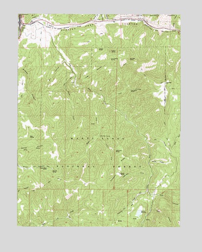
Thistle, UT USGS Topographic Map
Click on map above to begin viewing in our Map Viewer.

This topographic map contains these locations and features:
Feature Name Type Latitude Longitude GNIS ID View Map
Buggy Wheel SpringSpringN39.9100°W111.4781°1439258View Map
Chicken HollowValleyN39.9963°W111.4410°1439676View Map
Coal HollowValleyN39.9491°W111.4344°1439838View Map
Coal Hollow SpringSpringN39.9558°W111.4135°1439843View Map
Coffeepot CreekStreamN39.9066°W111.3971°1439857View Map
Coffeepot RidgeRidgeN39.9094°W111.4238°1439858View Map
Coffeepot SpringSpringN39.9062°W111.4184°1439859View Map
Dipping Pen CreekStreamN39.8972°W111.4007°1440468View Map
Dry HollowValleyN39.9725°W111.4652°1440643View Map
Jumpup SpringSpringN39.9795°W111.4388°1442249View Map
Lake ForkStreamN39.9930°W111.4771°1442405View Map
Lake Fork Wildlife Management AreaParkN39.9572°W111.4771°1448565View Map
Left Fork Lake ForkStreamN39.9300°W111.4380°1442506View Map
Left Fork Right ForkStreamN39.9300°W111.4382°1448585View Map
Little Bear SpringSpringN39.9281°W111.4382°1442666View Map
Long HollowValleyN39.9583°W111.4549°1442912View Map
Long HollowValleyN39.9966°W111.4324°1442920View Map
Long Hollow SpringSpringN39.9736°W111.4295°1442921View Map
Lookout SpringSpringN39.9783°W111.4255°1442947View Map
Mud SpringSpringN39.9277°W111.4914°1443700View Map
Oil HollowValleyN39.9255°W111.4019°1444060View Map
Right ForkStreamN39.9494°W111.4349°1448917View Map
Right Fork Lake ForkStreamN39.9494°W111.4352°1444928View Map
Right Fork SpringSpringN39.9195°W111.4254°1444960View Map
RioPopulated PlaceN39.9958°W111.4271°1444990View Map
Rock CanyonValleyN39.8858°W111.3977°1445037View Map
Rough HollowValleyN39.9919°W111.3805°1445157View Map
Side CanyonValleyN39.8941°W111.3988°1445568View Map
Sky HighSummitN39.9597°W111.3871°1445648View Map
Sky High SpringSpringN39.9742°W111.4150°1445649View Map
Sky High TrailTrailN39.9588°W111.3913°1445650View Map
Slab Pile SpringSpringN39.9083°W111.4739°1445657View Map
Smiths DamDamN39.8850°W111.4074°1447812View Map
Smiths ReservoirReservoirN39.8834°W111.4072°1447811View Map
Soldier CreekStreamN39.9947°W111.4985°1445768View Map
Spring HollowValleyN39.9133°W111.3996°1446036View Map
Sweat CreekStreamN39.9638°W111.4555°1446284View Map
The Red NarrowsGapN39.9897°W111.3921°1446498View Map
ThistlePopulated PlaceN39.9913°W111.4982°1446533View Map
Thistle CreekStreamN39.9947°W111.4985°1446534View Map
Thistle SubstationFlatN39.9977°W111.4863°1446536View Map

Note: Coordinates in the location and feature list above are referenced to NAD83 datum.


Copyright (C) 2008-2024 Ryan Niemi / Sunset Dynamics ... All Rights Reserved