TopoQuest Logo
Do you find TopoQuest useful?
Help keep TopoQuest running and adding new maps/features by donating!
Bitcoin:  19c7KJd3qBynnjoSw5npx9KScwjBe4ifkT
Litecoin:  LXs6TkuXGGXo1vDsWCkWVdjQX94eUKd6ui
Home View Maps Find Maps Find Places Resources & Links


Capitol Peak, Washington Topographic Map

USGS Map Title: Capitol Peak, WA
USGS Map MRC: 46123H2
DRG (GeoTIFF) Download: o46123h2.tif


Neighboring USGS Topographic Map Quads:


  McCleary, WA  
47123A3
 

  Kamilche Valley, WA  
47123A2
 

  Summit Lake, WA  
47123A1
 

  Malone, WA  
46123H3
 

  Capitol Peak, WA  
46123H2
 

  Littlerock, WA  
46123H1
 

  Cedarville, WA  
46123G3
 

  Oakville, WA  
46123G2
 

  Rochester, WA  
46123G1


Map MRC Location:

N47°
W124°
N47°
W123°
H8 H7 H6 H5 H4 H3 H2 H1
G8 G7 G6 G5 G4 G3 G2 G1
F8 F7 F6 F5 F4 F3 F2 F1
E8 E7 E6 E5 E4 E3 E2 E1
D8 D7 D6 D5 D4 D3 D2 D1
C8 C7 C6 C5 C4 C3 C2 C1
B8 B7 B6 B5 B4 B3 B2 B1
A8 A7 A6 A5 A4 A3 A2 A1
N46°
W124°
N46°
W123°

Capitol Peak, WA USGS 1:24K Topographic Map Preview:
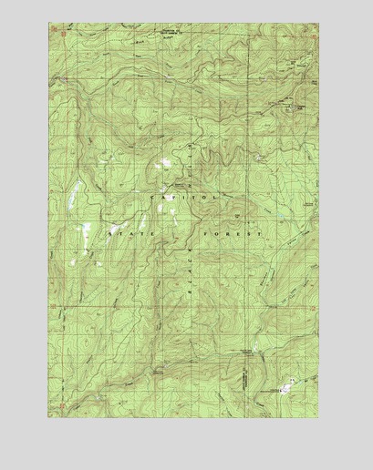
Capitol Peak, WA USGS Topographic Map
Click on map above to begin viewing in our Map Viewer.

This topographic map contains these locations and features:
Feature Name Type Latitude Longitude GNIS ID View Map
Black HillsRangeN46.9873°W123.1376°1503402View Map
Bozy CreekStreamN46.9982°W123.2404°1503521View Map
Buck RidgeRidgeN46.9993°W123.1851°1503605View Map
Capitol PeakSummitN46.9729°W123.1363°1503802View Map
Capitol Peak LookoutLocaleN46.9726°W123.1393°1512922View Map
Capitol State ForestForestN46.9498°W123.1679°1513076View Map
Cedar Creek State Correction CenterBuildingN46.8837°W123.1440°1510356View Map
Fall CreekStreamN46.9384°W123.1251°1504816View Map
Fall Creek CampgroundLocaleN46.9426°W123.1285°1509994View Map
Fuzzy TopSummitN46.9384°W123.1635°1512231View Map
Hell CreekStreamN46.9757°W123.2318°1505454View Map
Iron CreekStreamN46.9712°W123.2310°1505748View Map
Larch MountainSummitN46.9873°W123.1376°1513143View Map
Lost ValleyValleyN46.9104°W123.1468°1511613View Map
Lost Valley CreekStreamN46.9098°W123.1496°1511630View Map
Monroe CreekStreamN46.9323°W123.1332°1506759View Map
North CreekStreamN46.8904°W123.2035°1507022View Map
North Creek CampgroundLocaleN46.8898°W123.2035°1509996View Map
North Creek Truck TrailTrailN46.9259°W123.2035°1507026View Map
North Fork Porter CreekStreamN46.9826°W123.2457°1507063View Map
Porter Creek Truck TrailTrailN46.9432°W123.2121°1507587View Map
Sherman CreekStreamN46.8954°W123.1535°1511619View Map
Sherman ValleyValleyN46.9134°W123.1501°1508297View Map
Sherman Valley CampgroundLocaleN46.8968°W123.1568°1509995View Map
South Fork Porter CreekStreamN46.9826°W123.2460°1508542View Map
Swan CreekStreamN46.9984°W123.2213°1508858View Map
Thurston CreekStreamN46.9076°W123.2438°1509020View Map
Wedekind Picnic AreaLocaleN46.9487°W123.1940°1509993View Map

Note: Coordinates in the location and feature list above are referenced to NAD83 datum.


Copyright (C) 2008-2024 Ryan Niemi / Sunset Dynamics ... All Rights Reserved