TopoQuest Logo
Do you find TopoQuest useful?
Help keep TopoQuest running and adding new maps/features by donating!
Bitcoin:  19c7KJd3qBynnjoSw5npx9KScwjBe4ifkT
Litecoin:  LXs6TkuXGGXo1vDsWCkWVdjQX94eUKd6ui
Home View Maps Find Maps Find Places Resources & Links


Caplinger Mills, Missouri Topographic Map

USGS Map Title: Caplinger Mills, MO
USGS Map MRC: 37093G7
DRG (GeoTIFF) Download: o37093g7.tif


Neighboring USGS Topographic Map Quads:


  Tiffin, MO  
37093H8
 

  Roscoe, MO  
37093H7
 

  Vista, MO  
37093H6
 

  Filley, MO  
37093G8
 

  Caplinger Mills, MO  
37093G7
 

  Arnica, MO  
37093G6
 

  Wagoner, MO  
37093F8
 

  Stockton, MO  
37093F7
 

  Bearcreek, MO  
37093F6


Map MRC Location:

N38°
W94°
N38°
W93°
H8 H7 H6 H5 H4 H3 H2 H1
G8 G7 G6 G5 G4 G3 G2 G1
F8 F7 F6 F5 F4 F3 F2 F1
E8 E7 E6 E5 E4 E3 E2 E1
D8 D7 D6 D5 D4 D3 D2 D1
C8 C7 C6 C5 C4 C3 C2 C1
B8 B7 B6 B5 B4 B3 B2 B1
A8 A7 A6 A5 A4 A3 A2 A1
N37°
W94°
N37°
W93°

Caplinger Mills, MO USGS 1:24K Topographic Map Preview:
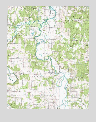
Caplinger Mills, MO USGS Topographic Map
Click on map above to begin viewing in our Map Viewer.

This topographic map contains these locations and features:
Feature Name Type Latitude Longitude GNIS ID View Map
BlackjackPopulated PlaceN37.8723°W93.7919°758174View Map
Blackjack School (historical)SchoolN37.8745°W93.7902°755783View Map
Bland HollowValleyN37.8564°W93.8724°714354View Map
Bluff Springs School (historical)SchoolN37.7859°W93.7610°714447View Map
Camp CreekStreamN37.8484°W93.8622°755849View Map
Caplinger MillsPopulated PlaceN37.7942°W93.8044°729854View Map
Caplinger Mills DamDamN37.7934°W93.8002°763286View Map
Caplinger Mills School (historical)SchoolN37.7925°W93.8052°746213View Map
Caplinger Mills Volunteer Fire DepartmentBuildingN37.7974°W93.8051°2620666View Map
Cave BranchStreamN37.8556°W93.8394°755867View Map
Cave HillSummitN37.8711°W93.8483°715513View Map
Cedar BluffCliffN37.7884°W93.8605°715564View Map
Cedar CreekStreamN37.8509°W93.8230°715586View Map
Church HollowValleyN37.7945°W93.8644°715845View Map
Cline Hill School (historical)SchoolN37.8303°W93.8483°748346View Map
Coal Bank HillsRangeN37.7914°W93.7530°716027View Map
Cowan Lake EastReservoirN37.8416°W93.8358°763257View Map
Cowan Lake East DamDamN37.8434°W93.8335°763256View Map
Cowan Lake WestReservoirN37.8416°W93.8379°763486View Map
Cowan Lake West DamDamN37.8417°W93.8369°763485View Map
Dorman LakeReservoirN37.8618°W93.8298°763488View Map
Dorman Lake DamDamN37.8600°W93.8285°763487View Map
Elliston School (historical)SchoolN37.7909°W93.8280°748356View Map
Fairview (historical)Populated PlaceN37.8125°W93.8691°754350View Map
Flatrock School (historical)SchoolN37.8725°W93.8327°748363View Map
Flood BranchStreamN37.7542°W93.8741°718032View Map
GracelandPopulated PlaceN37.7559°W93.7660°740052View Map
Greenwood School (historical)SchoolN37.8575°W93.7549°756132View Map
Hackleman CemeteryCemeteryN37.8123°W93.8605°718958View Map
Hackleman CornerPopulated PlaceN37.8511°W93.8749°740894View Map
Hackleman Corner LakeReservoirN37.8289°W93.8749°736102View Map
Haynie Branch Natural BridgesArchN37.8547°W93.7536°2680492View Map
Hickman Lake DamDamN37.7500°W93.8135°763258View Map
Horseshoe BendBendN37.7834°W93.7941°719858View Map
IvyPopulated PlaceN37.7711°W93.8655°740054View Map
Keith IslandIslandN37.7609°W93.7863°720492View Map
Leila StoreLocaleN37.8714°W93.8352°720901View Map
Little Turkey CreekStreamN37.8231°W93.7777°721342View Map
Love School (historical)SchoolN37.8725°W93.8594°755482View Map
Masters IslandIslandN37.7748°W93.7847°721967View Map
Moore BluffCliffN37.8259°W93.7774°722563View Map
Mount Enon School (historical)SchoolN37.8123°W93.7533°748416View Map
Mount Olive School (historical)SchoolN37.8423°W93.8105°756422View Map
Old Union ChurchChurchN37.7625°W93.7647°723796View Map
Panther Den HollowValleyN37.8578°W93.7663°756499View Map
Parker CemeteryCemeteryN37.7564°W93.8052°724031View Map
Parker School (historical)SchoolN37.7689°W93.8099°748430View Map
Preston CemeteryCemeteryN37.8342°W93.8038°724917View Map
Rich Hill School (historical)SchoolN37.7528°W93.7680°748444View Map
Ritchson HollowValleyN37.7884°W93.7799°725332View Map
Rock School (historical)SchoolN37.8142°W93.8716°748447View Map
RookinsPopulated PlaceN37.8389°W93.7574°756610View Map
Rookins CemeteryCemeteryN37.8381°W93.7588°756408View Map
Sac River ReservoirReservoirN37.7930°W93.8008°763287View Map
Silver CreekStreamN37.7589°W93.7813°726446View Map
Spring Valley School (historical)SchoolN37.8186°W93.7941°748457View Map
Stockton BranchStreamN37.7500°W93.7938°727120View Map
Township of CedarCivilN37.8410°W93.8745°766451View Map
Township of WashingtonCivilN37.7935°W93.7630°766455View Map
Turkey CreekStreamN37.8599°W93.8069°756806View Map
Vilhauer BluffCliffN37.8636°W93.8017°756848View Map
West Union Missionary Baptist ChurchChurchN37.7689°W93.8674°748267View Map
West Union School (historical)SchoolN37.7714°W93.8566°748475View Map
Wright HollowValleyN37.8598°W93.7813°756930View Map
Younger SloughLakeN37.7538°W93.7912°729212View Map

Note: Coordinates in the location and feature list above are referenced to NAD83 datum.


Copyright (C) 2008-2024 Ryan Niemi / Sunset Dynamics ... All Rights Reserved