TopoQuest Logo
Do you find TopoQuest useful?
Help keep TopoQuest running and adding new maps/features by donating!
Bitcoin:  19c7KJd3qBynnjoSw5npx9KScwjBe4ifkT
Litecoin:  LXs6TkuXGGXo1vDsWCkWVdjQX94eUKd6ui
Home View Maps Find Maps Find Places Resources & Links


Woodbine, Kansas Topographic Map

USGS Map Title: Woodbine, KS
USGS Map MRC: 38096G8
DRG (GeoTIFF) Download: o38096g8.tif


Neighboring USGS Topographic Map Quads:


  Chapman, KS  
38097H1
 

  Kansas Falls, KS  
38096H8
 

  Wreford, KS  
38096H7
 

  Navarre, KS  
38097G1
 

  Woodbine, KS  
38096G8
 

  Skiddy, KS  
38096G7
 

  Hope, KS  
38097F1
 

  Herington, KS  
38096F8
 

  Delavan, KS  
38096F7


Map MRC Location:

N39°
W97°
N39°
W96°
H8 H7 H6 H5 H4 H3 H2 H1
G8 G7 G6 G5 G4 G3 G2 G1
F8 F7 F6 F5 F4 F3 F2 F1
E8 E7 E6 E5 E4 E3 E2 E1
D8 D7 D6 D5 D4 D3 D2 D1
C8 C7 C6 C5 C4 C3 C2 C1
B8 B7 B6 B5 B4 B3 B2 B1
A8 A7 A6 A5 A4 A3 A2 A1
N38°
W97°
N38°
W96°

Woodbine, KS USGS 1:24K Topographic Map Preview:
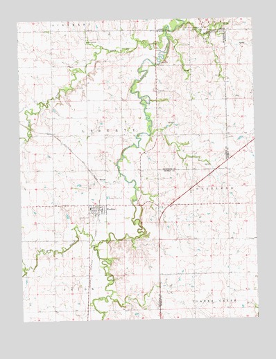
Woodbine, KS USGS Topographic Map
Click on map above to begin viewing in our Map Viewer.

This topographic map contains these locations and features:
Feature Name Type Latitude Longitude GNIS ID View Map
Camp-Wa-shun-gaLocaleN38.8711°W96.9045°476869View Map
Carry CreekStreamN38.8708°W96.9217°476866View Map
Carry Creek School (historical)SchoolN38.8661°W96.9639°476867View Map
City of WoodbineCivilN38.7956°W96.9594°2397366View Map
Liberty Township Woodbine Fire Department District 1BuildingN38.7960°W96.9569°2111541View Map
LyonaPopulated PlaceN38.8619°W96.9258°484795View Map
Lyona CemeteryCemeteryN38.8630°W96.9271°2673238View Map
Lyona United Methodist ChurchChurchN38.8630°W96.9260°2689480View Map
North Central Kansas Co - Operative Association Grain Elevator Number 4LocaleN38.7965°W96.9588°2695276View Map
Rock Springs RanchLocaleN38.8694°W96.8975°476868View Map
Township of LibertyCivilN38.8296°W96.9691°476861View Map
West Branch Lyon CreekStreamN38.7811°W96.9611°476863View Map
WoodbinePopulated PlaceN38.7961°W96.9586°476865View Map
Woodbine CemeteryCemeteryN38.7927°W96.9639°476864View Map
Woodbine Post OfficePost OfficeN38.7962°W96.9574°2694033View Map
Woodbine United Methodist ChurchChurchN38.7972°W96.9615°2689574View Map
Woodbine Wastewater Treatment FacilityLocaleN38.8011°W96.9539°2693585View Map

Note: Coordinates in the location and feature list above are referenced to NAD83 datum.


Copyright (C) 2008-2025 Ryan Niemi / Sunset Dynamics ... All Rights Reserved