TopoQuest Logo
Do you find TopoQuest useful?
Help keep TopoQuest running and adding new maps/features by donating!
Bitcoin:  19c7KJd3qBynnjoSw5npx9KScwjBe4ifkT
Litecoin:  LXs6TkuXGGXo1vDsWCkWVdjQX94eUKd6ui
Home View Maps Find Maps Find Places Resources & Links


Capron, Illinois Topographic Map

USGS Map Title: Capron, IL
USGS Map MRC: 42088D6
DRG (GeoTIFF) Download: o42088d6.tif


Neighboring USGS Topographic Map Quads:


  Clinton, WI  
42088E7
 

  Sharon, WI  
42088E6
 

  Walworth, WI  
42088E5
 

  Belvidere NE, IL  
42088D7
 

  Capron, IL  
42088D6
 

  Harvard, IL  
42088D5
 

  Belvidere North, IL  
42088C7
 

  Garden Prairie, IL  
42088C6
 

  Marengo North, IL  
42088C5


Map MRC Location:

N43°
W89°
N43°
W88°
H8 H7 H6 H5 H4 H3 H2 H1
G8 G7 G6 G5 G4 G3 G2 G1
F8 F7 F6 F5 F4 F3 F2 F1
E8 E7 E6 E5 E4 E3 E2 E1
D8 D7 D6 D5 D4 D3 D2 D1
C8 C7 C6 C5 C4 C3 C2 C1
B8 B7 B6 B5 B4 B3 B2 B1
A8 A7 A6 A5 A4 A3 A2 A1
N42°
W89°
N42°
W88°

Capron, IL USGS 1:24K Topographic Map Preview:
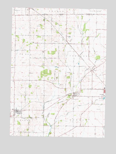
Capron, IL USGS Topographic Map
Click on map above to begin viewing in our Map Viewer.

This topographic map contains these locations and features:
Feature Name Type Latitude Longitude GNIS ID View Map
Barrows School (historical)SchoolN42.3853°W88.6623°1695280View Map
Becks WoodsWoodsN42.4145°W88.6732°1773501View Map
Boone County Fire Protection District 1BuildingN42.3980°W88.7414°2682379View Map
Burr Oak CemeteryCemeteryN42.4661°W88.7198°405259View Map
Burr Oak School (historical)SchoolN42.4678°W88.7265°1695273View Map
CapronPopulated PlaceN42.3997°W88.7404°405572View Map
Capron CemeteryCemeteryN42.3942°W88.7404°1955270View Map
Capron Elementary SchoolSchoolN42.4009°W88.7468°1764563View Map
Capron Post OfficePost OfficeN42.3992°W88.7412°2788534View Map
Capron Rescue SquadBuildingN42.3996°W88.7407°2674027View Map
ChemungPopulated PlaceN42.4153°W88.6668°406004View Map
Chemung Census Designated PlaceCensusN42.4162°W88.6642°2628545View Map
Chemung-Dunham CemeteryCemeteryN42.4120°W88.6693°406005View Map
Chermung CemeteryCemeteryN42.4186°W88.6620°1955534View Map
Chester CemeteryCemeteryN42.3928°W88.7204°406028View Map
Dacy AirportAirportN42.4064°W88.6325°427354View Map
Dullam CemeteryCemeteryN42.4361°W88.7254°407475View Map
Dullam School (historical)SchoolN42.4292°W88.7298°1695274View Map
Dunham School (historical)SchoolN42.4111°W88.6729°1695291View Map
LawrencePopulated PlaceN42.4411°W88.6412°411867View Map
Lawrence CreekStreamN42.4286°W88.6598°411868View Map
Long Prairie CemeteryCemeteryN42.3925°W88.7295°407620View Map
Mary's LandingAirportN42.4121°W88.7326°2679034View Map
Mokeler CreekStreamN42.3856°W88.6965°413707View Map
Munch HeliportAirportN42.4220°W88.7307°427136View Map
Pine Hill AirportAirportN42.4656°W88.7442°427101View Map
SD AeroAirportN42.4313°W88.7145°2679033View Map
Sharon Wastewater Treatment PlantLocaleN42.4983°W88.7461°2709436View Map
State Line School (historical)SchoolN42.4939°W88.6784°1695308View Map
Township of ChemungCivilN42.4548°W88.6478°428795View Map
Twin Gardens AirportAirportN42.4109°W88.6475°427356View Map
Village of CapronCivilN42.3986°W88.7393°2397549View Map
West Branch Piscasaw CreekStreamN42.4202°W88.6693°420795View Map
White Oak School (historical)SchoolN42.4656°W88.6879°1695312View Map

Note: Coordinates in the location and feature list above are referenced to NAD83 datum.


Copyright (C) 2008-2024 Ryan Niemi / Sunset Dynamics ... All Rights Reserved