TopoQuest Logo
Do you find TopoQuest useful?
Help keep TopoQuest running and adding new maps/features by donating!
Bitcoin:  19c7KJd3qBynnjoSw5npx9KScwjBe4ifkT
Litecoin:  LXs6TkuXGGXo1vDsWCkWVdjQX94eUKd6ui
Home View Maps Find Maps Find Places Resources & Links


Bass Lake, California Topographic Map

USGS Map Title: Bass Lake, CA
USGS Map MRC: 37119C5
DRG (GeoTIFF) Download: o37119c5.tif


Neighboring USGS Topographic Map Quads:


  Fish Camp, CA  
37119D6
 

  White Chief Mountain, CA  
37119D5
 

  Little Shuteye Peak, CA  
37119D4
 

  Ahwahnee, CA  
37119C6
 

  Bass Lake, CA  
37119C5
 

  Shuteye Peak, CA  
37119C4
 

  O'Neals, CA  
37119B6
 

  North Fork, CA  
37119B5
 

  Cascadel Point, CA  
37119B4


Map MRC Location:

N38°
W120°
N38°
W119°
H8 H7 H6 H5 H4 H3 H2 H1
G8 G7 G6 G5 G4 G3 G2 G1
F8 F7 F6 F5 F4 F3 F2 F1
E8 E7 E6 E5 E4 E3 E2 E1
D8 D7 D6 D5 D4 D3 D2 D1
C8 C7 C6 C5 C4 C3 C2 C1
B8 B7 B6 B5 B4 B3 B2 B1
A8 A7 A6 A5 A4 A3 A2 A1
N37°
W120°
N37°
W119°

Bass Lake, CA USGS 1:24K Topographic Map Preview:
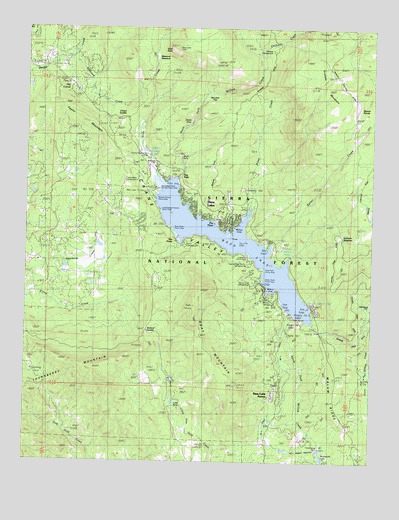
Bass Lake, CA USGS Topographic Map
Click on map above to begin viewing in our Map Viewer.

This topographic map contains these locations and features:
Feature Name Type Latitude Longitude GNIS ID View Map
Angle FallsFallsN37.3383°W119.5707°252519View Map
Bass LakePopulated PlaceN37.3247°W119.5663°256579View Map
Bass LakeReservoirN37.3119°W119.5511°266417View Map
Bass Lake AnnexPopulated PlaceN37.2713°W119.5340°252520View Map
Bass Lake Census Designated PlaceCensusN37.3282°W119.5667°2628709View Map
Bass Lake Elementary SchoolSchoolN37.3355°W119.5801°256580View Map
Bass Lake Lodge ResortLocaleN37.3255°W119.5685°275804View Map
Bass Lake Post OfficePost OfficeN37.3204°W119.5561°1667653View Map
Bass Lake Post Office (historical)Post OfficeN37.3247°W119.5663°2026839View Map
Bass Lake StationLocaleN37.3274°W119.5832°253091View Map
Bass Lake VistaLocaleN37.3688°W119.5718°253092View Map
Beaver PondsLocaleN37.3494°W119.5076°253093View Map
Browns Creek DitchCanalN37.2849°W119.5051°252521View Map
Camp Santa Teresita (historical)LocaleN37.3291°W119.5840°257895View Map
Chepo SaddleGapN37.3488°W119.5901°258235View Map
Chilkoot CampgroundLocaleN37.3627°W119.5396°258282View Map
Chilkoot CreekStreamN37.3655°W119.5410°258283View Map
Crane ValleyValleyN37.2897°W119.5221°266607View Map
Crane Valley CampgroundLocaleN37.3333°W119.5863°253094View Map
Crane Valley PowerhouseLocaleN37.2916°W119.5293°1654889View Map
Crane Valley Storage 95-003 DamDamN37.2916°W119.5310°1663579View Map
Denver Church CampgroundLocaleN37.3255°W119.5793°259279View Map
Denver Church Picnic AreaLocaleN37.3258°W119.5793°1667656View Map
Department of Forestry and Fire Protection Bass Lake StationBuildingN37.3270°W119.5824°2624580View Map
Devils SlideRapidsN37.3480°W119.5665°252522View Map
Effluent FieldAreaN37.3463°W119.5963°252523View Map
Falls Beach Picnic AreaLocaleN37.3302°W119.5713°253095View Map
Forks CampgroundLocaleN37.3130°W119.5710°260269View Map
Forks ResortLocaleN37.3108°W119.5826°275805View Map
Goat MountainSummitN37.2949°W119.5651°1658626View Map
Goat Mountain LookoutLocaleN37.2719°W119.5668°275810View Map
Goat Mountain TrailTrailN37.3027°W119.5585°1812713View Map
Government CenterBuildingN37.3380°W119.5813°253096View Map
Graham MeadowFlatN37.3149°W119.5126°260732View Map
Graham MountainSummitN37.3574°W119.5171°260733View Map
Hole RanchLocaleN37.2949°W119.5018°253512View Map
KTNS-AM (Oakhurst)TowerN37.3019°W119.6140°1662677View Map
Lake MoicLakeN37.2672°W119.5722°263728View Map
Little Denver Church CampgroundLocaleN37.3230°W119.5782°253097View Map
Little Denver Church Picnic AreaLocaleN37.3227°W119.5776°1667657View Map
Lupine-Cedar Bluffs CampgroundLocaleN37.3077°W119.5451°263072View Map
Madera County Fire Department Station 14BuildingN37.3384°W119.5826°2623863View Map
Madera County Sheriff's Office SubstationBuildingN37.3383°W119.5820°2755929View Map
McLeod FlatFlatN37.3558°W119.5576°263314View Map
Meserve MeadowFlatN37.3666°W119.5801°252524View Map
Millers Landing ResortLocaleN37.2980°W119.5390°275809View Map
Number 3 Forebay 95-006 DamDamN37.2533°W119.5310°1663583View Map
Number Three DitchCanalN37.2619°W119.5382°252525View Map
Number Three Forbay PenstockCanalN37.2533°W119.5257°252526View Map
Old CorralPopulated PlaceN37.3569°W119.6071°252527View Map
Pine Point Picnic AreaLocaleN37.3052°W119.5410°1667870View Map
Pine Slope Picnic AreaLocaleN37.3169°W119.5732°1667871View Map
Pines CreekStreamN37.3222°W119.5465°264788View Map
Powerhouse Number ThreeLocaleN37.2544°W119.5193°1654890View Map
Rancheria CreekStreamN37.3038°W119.6246°267154View Map
Recreation PointLocaleN37.3283°W119.5785°253098View Map
Recreation Point CampgroundLocaleN37.3286°W119.5788°275807View Map
Redwood CreekStreamN37.3663°W119.6126°265346View Map
Rocky Point Picnic AreaLocaleN37.3022°W119.5410°1652855View Map
Salter CreekStreamN37.3127°W119.5368°252528View Map
Sheriffs TowerLocaleN37.3147°W119.5518°253099View Map
Sierra Ambulance Service Bass Lake StationBuildingN37.3201°W119.5588°2662302View Map
Slick RockSlopeN37.3677°W119.5729°252529View Map
Slide CreekStreamN37.3313°W119.5790°266290View Map
Spring Cove CampgroundLocaleN37.3005°W119.5424°267589View Map
Taylor MountainSummitN37.3491°W119.6049°1659960View Map
Teaford Ranch (historical)LocaleN37.2730°W119.5838°268112View Map
Teaford SaddleGapN37.2877°W119.5832°268113View Map
The FallsLocaleN37.3324°W119.5721°268186View Map
The Falls Picnic AreaLocaleN37.3299°W119.5710°1812731View Map
The ForksLocaleN37.3138°W119.5721°236167View Map
The PinesPopulated PlaceN37.3188°W119.5532°1659988View Map
Thornberry MountainSummitN37.2766°W119.5999°1659994View Map
Two Springs Campground (historical)LocaleN37.3149°W119.5649°268557View Map
Way of the Mono TrailTrailN37.3269°W119.5824°1812732View Map
Willow CoveBayN37.3174°W119.5485°252530View Map
Willow Cove Picnic AreaLocaleN37.3233°W119.5451°253100View Map
Willow Creek TrailTrailN37.3447°W119.5699°1812733View Map
Wishon Airport (historical)AirportN37.3333°W119.5808°2106333View Map
Wishon CoveBayN37.2994°W119.5376°269259View Map
Wishon Point Boat LaunchLocaleN37.2955°W119.5329°253101View Map
Wishon Point CampgroundLocaleN37.2972°W119.5349°1667893View Map

Note: Coordinates in the location and feature list above are referenced to NAD83 datum.


Copyright (C) 2008-2025 Ryan Niemi / Sunset Dynamics ... All Rights Reserved