TopoQuest Logo
Do you find TopoQuest useful?
Help keep TopoQuest running and adding new maps/features by donating!
Bitcoin:  19c7KJd3qBynnjoSw5npx9KScwjBe4ifkT
Litecoin:  LXs6TkuXGGXo1vDsWCkWVdjQX94eUKd6ui
Home View Maps Find Maps Find Places Resources & Links


Fish Camp, California Topographic Map

USGS Map Title: Fish Camp, CA
USGS Map MRC: 37119D6
DRG (GeoTIFF) Download: o37119d6.tif


Neighboring USGS Topographic Map Quads:


  Buckingham Mountain, CA  
37119E7
 

  Wawona, CA  
37119E6
 

  Mariposa Grove, CA  
37119E5
 

  Stumpfield Mountain, CA  
37119D7
 

  Fish Camp, CA  
37119D6
 

  White Chief Mountain, CA  
37119D5
 

  Horsecamp Mountain, CA  
37119C7
 

  Ahwahnee, CA  
37119C6
 

  Bass Lake, CA  
37119C5


Map MRC Location:

N38°
W120°
N38°
W119°
H8 H7 H6 H5 H4 H3 H2 H1
G8 G7 G6 G5 G4 G3 G2 G1
F8 F7 F6 F5 F4 F3 F2 F1
E8 E7 E6 E5 E4 E3 E2 E1
D8 D7 D6 D5 D4 D3 D2 D1
C8 C7 C6 C5 C4 C3 C2 C1
B8 B7 B6 B5 B4 B3 B2 B1
A8 A7 A6 A5 A4 A3 A2 A1
N37°
W120°
N37°
W119°

Fish Camp, CA USGS 1:24K Topographic Map Preview:
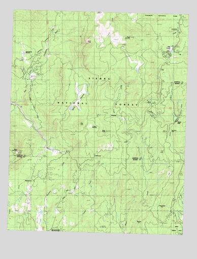
Fish Camp, CA USGS Topographic Map
Click on map above to begin viewing in our Map Viewer.

This topographic map contains these locations and features:
Feature Name Type Latitude Longitude GNIS ID View Map
Ahwahnee SanatoriumHospitalN37.3816°W119.7318°1655793View Map
Bald RockPillarN37.4833°W119.6985°256472View Map
Batterson StationLocaleN37.3780°W119.6296°275615View Map
BurfordLocaleN37.3813°W119.6535°257703View Map
CedarbrookLocaleN37.4199°W119.6902°253084View Map
China WellsLocaleN37.3916°W119.6449°258319View Map
Cold SpringSpringN37.4720°W119.7425°258537View Map
Cold Spring MeadowFlatN37.4741°W119.7432°258561View Map
Cunningham School (historical)SchoolN37.4036°W119.7321°258989View Map
Fish CampPopulated PlaceN37.4785°W119.6404°260142View Map
Fish Camp Census Designated PlaceCensusN37.4797°W119.6373°2583013View Map
Fish Camp Post OfficePost OfficeN37.4793°W119.6385°1667661View Map
Happy CampLocaleN37.4686°W119.6457°261070View Map
Harris Ranch (historical)LocaleN37.4633°W119.7388°261109View Map
Harris Ranch MillLocaleN37.4622°W119.7382°253085View Map
Hogan MountainSummitN37.4859°W119.6667°261402View Map
KAAT-FM (Oakhurst)TowerN37.4188°W119.7354°1665064View Map
Lone Sequoia CampgroundLocaleN37.4283°W119.6688°262813View Map
Manzanita Airport (historical)AirportN37.4573°W119.7416°2650946View Map
Mariposa County Fire Department Company 32 Ponderosa BasinBuildingN37.4642°W119.7361°2624359View Map
Mariposa County Fire Department Company 33 Fish CampBuildingN37.4752°W119.6393°2623749View Map
Miami MountainSummitN37.4193°W119.7454°263486View Map
Miami Mountain LookoutLocaleN37.4191°W119.7454°275610View Map
NipinnawaseePopulated PlaceN37.4041°W119.7329°1656190View Map
Nipinnawasee Census Designated PlaceCensusN37.4031°W119.7293°2628765View Map
O'Neals MeadowFlatN37.4352°W119.6938°267088View Map
Pilot PeakSummitN37.4364°W119.7012°264738View Map
Ponderosa BasinPopulated PlaceN37.4660°W119.7357°1809330View Map
Red Rock FallsFallsN37.4338°W119.6365°252518View Map
Silver KnobSummitN37.4326°W119.6829°266193View Map
Sonny MeadowsFlatN37.4505°W119.7015°1667883View Map
Sugar PinePopulated PlaceN37.4411°W119.6343°1656338View Map
Summerdale CampgroundLocaleN37.4919°W119.6335°267912View Map
TimberloftLocaleN37.4413°W119.6757°1652863View Map
Westfall Picnic AreaLocaleN37.4441°W119.6529°1652870View Map
Westfall StationLocaleN37.4494°W119.6507°1667891View Map
Worman MillLocaleN37.4205°W119.7099°253086View Map
Yosemite Mountain Sugar Pine Historical RailroadParkN37.4533°W119.6393°253087View Map

Note: Coordinates in the location and feature list above are referenced to NAD83 datum.


Copyright (C) 2008-2025 Ryan Niemi / Sunset Dynamics ... All Rights Reserved