TopoQuest Logo
Do you find TopoQuest useful?
Help keep TopoQuest running and adding new maps/features by donating!
Bitcoin:  19c7KJd3qBynnjoSw5npx9KScwjBe4ifkT
Litecoin:  LXs6TkuXGGXo1vDsWCkWVdjQX94eUKd6ui
Home View Maps Find Maps Find Places Resources & Links


Bayfield, Colorado Topographic Map

USGS Map Title: Bayfield, CO
USGS Map MRC: 37107B5
DRG (GeoTIFF) Download: o37107b5.tif


Neighboring USGS Topographic Map Quads:


  Rules Hill, CO  
37107C6
 

  Ludwig Mountain, CO  
37107C5
 

  Baldy Mountain, CO  
37107C4
 

  Gem Village, CO  
37107B6
 

  Bayfield, CO  
37107B5
 

  Pargin Mountain, CO  
37107B4
 

  Ignacio, CO  
37107A6
 

  Tiffany, CO  
37107A5
 

  Allison, CO  
37107A4


Map MRC Location:

N38°
W108°
N38°
W107°
H8 H7 H6 H5 H4 H3 H2 H1
G8 G7 G6 G5 G4 G3 G2 G1
F8 F7 F6 F5 F4 F3 F2 F1
E8 E7 E6 E5 E4 E3 E2 E1
D8 D7 D6 D5 D4 D3 D2 D1
C8 C7 C6 C5 C4 C3 C2 C1
B8 B7 B6 B5 B4 B3 B2 B1
A8 A7 A6 A5 A4 A3 A2 A1
N37°
W108°
N37°
W107°

Bayfield, CO USGS 1:24K Topographic Map Preview:
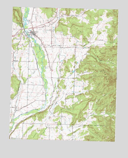
Bayfield, CO USGS Topographic Map
Click on map above to begin viewing in our Map Viewer.

This topographic map contains these locations and features:
Feature Name Type Latitude Longitude GNIS ID View Map
Armstrong CanyonValleyN37.2162°W107.5338°184400View Map
Arrowhead HillSummitN37.2342°W107.6145°184414View Map
BayfieldPopulated PlaceN37.2256°W107.5981°184411View Map
Bayfield CemeteryCemeteryN37.2371°W107.6034°184415View Map
Bayfield Post OfficePost OfficeN37.2276°W107.6021°2750884View Map
Bayfield Ranger StationLocaleN37.2272°W107.6014°196975View Map
Beaver CreekStreamN37.1492°W107.6067°184200View Map
Brinks DrawValleyN37.1417°W107.6230°184392View Map
Ceanoboo DitchCanalN37.1917°W107.5678°184408View Map
Commissioner DitchCanalN37.1306°W107.6228°203004View Map
Crowbar CreekStreamN37.2125°W107.5678°184409View Map
Dry CreekStreamN37.1392°W107.6203°184189View Map
Dry Creek DitchCanalN37.1528°W107.6189°203003View Map
Dunham GapGapN37.2353°W107.6156°184412View Map
Durant GapGapN37.2478°W107.6248°184413View Map
Green CanyonValleyN37.1717°W107.5380°184406View Map
Harper PondReservoirN37.1902°W107.5516°184416View Map
Long CanyonValleyN37.2194°W107.5048°184399View Map
Marcy-Shenandoah MineMineN37.2250°W107.5998°1734995View Map
Missouri CenterLocaleN37.1986°W107.6228°184410View Map
Pine River Bayfield DitchCanalN37.1722°W107.5395°184405View Map
Reservoir CanyonValleyN37.1873°W107.5493°184407View Map
Reservoir Number 2ReservoirN37.2417°W107.5589°201543View Map
Reservoir Number 2 DamDamN37.2417°W107.5589°201542View Map
Ritter CanyonValleyN37.2074°W107.5366°184402View Map
Sauls CreekStreamN37.2483°W107.5695°184201View Map
Schroeder DitchCanalN37.2417°W107.5987°202992View Map
Silver Reef Group MineMineN37.2250°W107.5998°1734996View Map
Spring Creek Extension DitchCanalN37.1417°W107.5542°203007View Map
Thompson Epperson DitchCanalN37.2331°W107.6173°202993View Map
Town of BayfieldCivilN37.2352°W107.5948°2411667View Map
Upper Pine River Fire Protection District Station 1BuildingN37.2304°W107.5914°2666946View Map
Ute Creek LateralCanalN37.1375°W107.5978°184404View Map
Zabel CanyonValleyN37.1509°W107.5262°184403View Map

Note: Coordinates in the location and feature list above are referenced to NAD83 datum.


Copyright (C) 2008-2024 Ryan Niemi / Sunset Dynamics ... All Rights Reserved