TopoQuest Logo
Do you find TopoQuest useful?
Help keep TopoQuest running and adding new maps/features by donating!
Bitcoin:  19c7KJd3qBynnjoSw5npx9KScwjBe4ifkT
Litecoin:  LXs6TkuXGGXo1vDsWCkWVdjQX94eUKd6ui
Home View Maps Find Maps Find Places Resources & Links


Gem Village, Colorado Topographic Map

USGS Map Title: Gem Village, CO
USGS Map MRC: 37107B6
DRG (GeoTIFF) Download: o37107b6.tif


Neighboring USGS Topographic Map Quads:


  Durango East, CO  
37107C7
 

  Rules Hill, CO  
37107C6
 

  Ludwig Mountain, CO  
37107C5
 

  Loma Linda, CO  
37107B7
 

  Gem Village, CO  
37107B6
 

  Bayfield, CO  
37107B5
 

  Bondad Hill, CO  
37107A7
 

  Ignacio, CO  
37107A6
 

  Tiffany, CO  
37107A5


Map MRC Location:

N38°
W108°
N38°
W107°
H8 H7 H6 H5 H4 H3 H2 H1
G8 G7 G6 G5 G4 G3 G2 G1
F8 F7 F6 F5 F4 F3 F2 F1
E8 E7 E6 E5 E4 E3 E2 E1
D8 D7 D6 D5 D4 D3 D2 D1
C8 C7 C6 C5 C4 C3 C2 C1
B8 B7 B6 B5 B4 B3 B2 B1
A8 A7 A6 A5 A4 A3 A2 A1
N37°
W108°
N37°
W107°

Gem Village, CO USGS 1:24K Topographic Map Preview:
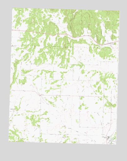
Gem Village, CO USGS Topographic Map
Click on map above to begin viewing in our Map Viewer.

This topographic map contains these locations and features:
Feature Name Type Latitude Longitude GNIS ID View Map
Brice CanyonValleyN37.2041°W107.7493°184388View Map
Chieftan MemorialLocaleN37.1283°W107.6312°184394View Map
Doctor Morrison DitchCanalN37.1667°W107.6423°203002View Map
Gem VillagePopulated PlaceN37.2192°W107.6373°184391View Map
Hartman CanyonValleyN37.2163°W107.6341°184185View Map
Holman CanyonValleyN37.2271°W107.6830°184187View Map
King Consolidated DitchCanalN37.2083°W107.6323°203000View Map
Long HollowValleyN37.2215°W107.7490°184188View Map
Los Pinos Fire Protection District Station 2 OxfordBuildingN37.1695°W107.7110°2666997View Map
Morrison Consolidated DitchCanalN37.1778°W107.6867°203001View Map
Ouray Memorial CemeteryCemeteryN37.1250°W107.6279°169448View Map
OxfordPopulated PlaceN37.1689°W107.7142°204733View Map
Pioneer DitchCanalN37.2278°W107.7390°202997View Map
Ridge DitchCanalN37.1928°W107.7089°184397View Map
Southern Ute AgencyLocaleN37.1319°W107.6339°184396View Map
Southern Ute Police DepartmentBuildingN37.1335°W107.6331°2757312View Map
Tri State Care FlightBuildingN37.1596°W107.7496°2716947View Map
Ute ParkParkN37.1267°W107.6323°184395View Map
Yeager CanyonValleyN37.2003°W107.6707°184389View Map

Note: Coordinates in the location and feature list above are referenced to NAD83 datum.


Copyright (C) 2008-2025 Ryan Niemi / Sunset Dynamics ... All Rights Reserved