TopoQuest Logo
Do you find TopoQuest useful?
Help keep TopoQuest running and adding new maps/features by donating!
Bitcoin:  19c7KJd3qBynnjoSw5npx9KScwjBe4ifkT
Litecoin:  LXs6TkuXGGXo1vDsWCkWVdjQX94eUKd6ui
Home View Maps Find Maps Find Places Resources & Links


Jim Jam Ridge, California Topographic Map

USGS Map Title: Jim Jam Ridge, CA
USGS Map MRC: 40123H3
DRG (GeoTIFF) Download: o40123h3.tif


Neighboring USGS Topographic Map Quads:


  Trinity Mountain, CA  
41123A4
 

  Dees Peak, CA  
41123A3
 

  Cecil Lake, CA  
41123A2
 

  Denny, CA  
40123H4
 

  Jim Jam Ridge, CA  
40123H3
 

  Thurston Peaks, CA  
40123H2
 

  Ironside Mountain, CA  
40123G4
 

  Del Loma, CA  
40123G3
 

  Helena, CA  
40123G2


Map MRC Location:

N41°
W124°
N41°
W123°
H8 H7 H6 H5 H4 H3 H2 H1
G8 G7 G6 G5 G4 G3 G2 G1
F8 F7 F6 F5 F4 F3 F2 F1
E8 E7 E6 E5 E4 E3 E2 E1
D8 D7 D6 D5 D4 D3 D2 D1
C8 C7 C6 C5 C4 C3 C2 C1
B8 B7 B6 B5 B4 B3 B2 B1
A8 A7 A6 A5 A4 A3 A2 A1
N40°
W124°
N40°
W123°

Jim Jam Ridge, CA USGS 1:24K Topographic Map Preview:
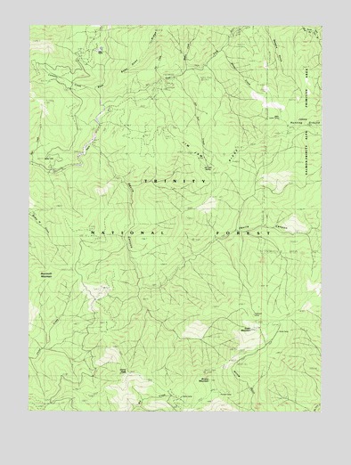
Jim Jam Ridge, CA USGS Topographic Map
Click on map above to begin viewing in our Map Viewer.

This topographic map contains these locations and features:
Feature Name Type Latitude Longitude GNIS ID View Map
Beartooth MountainSummitN40.9199°W123.3648°256751View Map
Brushy MountainSummitN40.8849°W123.2978°257549View Map
Caraway CreekStreamN40.9793°W123.3475°257966View Map
China PeakSummitN40.8871°W123.3334°258315View Map
Clems CampLocaleN40.8796°W123.3109°1665331View Map
Devils CanyonValleyN40.9601°W123.3467°259301View Map
East Fork New RiverStreamN40.9743°W123.3425°259744View Map
East Fork Trailhead ParkingLocaleN40.9812°W123.3167°276939View Map
Fall CreekStreamN40.9832°W123.3192°260027View Map
Green MountainSummitN40.9035°W123.2762°260861View Map
Hailstone CampLocaleN40.9029°W123.2823°261009View Map
Jakes Hunting GroundAreaN40.9690°W123.2603°261893View Map
Jakes Lower CampLocaleN40.9679°W123.2717°261894View Map
Jim Jam CreekStreamN40.9832°W123.3137°1665374View Map
Jim Jam RidgeRidgeN40.9526°W123.2962°261948View Map
Jim Jam SpringSpringN40.9543°W123.3000°1665375View Map
Miller RanchLocaleN40.9918°W123.3470°1665394View Map
Mills CreekStreamN40.9546°W123.3737°263650View Map
Mills HillSummitN40.9571°W123.3678°1659133View Map
Northwest Trinity DivisionCivilN40.8851°W123.2620°1935184View Map
Panther CampLocaleN40.8815°W123.2889°264467View Map
Pony CreekStreamN40.9996°W123.2839°264934View Map
Semore GulchValleyN40.9990°W123.2745°265992View Map
Stove CampLocaleN40.8982°W123.2706°267798View Map
Whisky CreekStreamN40.9857°W123.3078°268971View Map
White CreekStreamN40.9915°W123.2934°268990View Map

Note: Coordinates in the location and feature list above are referenced to NAD83 datum.


Copyright (C) 2008-2024 Ryan Niemi / Sunset Dynamics ... All Rights Reserved