TopoQuest Logo
Do you find TopoQuest useful?
Help keep TopoQuest running and adding new maps/features by donating!
Bitcoin:  19c7KJd3qBynnjoSw5npx9KScwjBe4ifkT
Litecoin:  LXs6TkuXGGXo1vDsWCkWVdjQX94eUKd6ui
Home View Maps Find Maps Find Places Resources & Links


Carbon Hill, Alabama Topographic Map

USGS Map Title: Carbon Hill, AL
USGS Map MRC: 33087H5
DRG (GeoTIFF) Download: o33087h5.tif


Neighboring USGS Topographic Map Quads:


  Gold Mine, AL  
34087A6
 

  Lynn, AL  
34087A5
 

  Poplar Springs, AL  
34087A4
 

  Glen Allen, AL  
33087H6
 

  Carbon Hill, AL  
33087H5
 

  Nauvoo, AL  
33087H4
 

  Hubbertville, AL  
33087G6
 

  Howard, AL  
33087G5
 

  Townley, AL  
33087G4


Map MRC Location:

N34°
W88°
N34°
W87°
H8 H7 H6 H5 H4 H3 H2 H1
G8 G7 G6 G5 G4 G3 G2 G1
F8 F7 F6 F5 F4 F3 F2 F1
E8 E7 E6 E5 E4 E3 E2 E1
D8 D7 D6 D5 D4 D3 D2 D1
C8 C7 C6 C5 C4 C3 C2 C1
B8 B7 B6 B5 B4 B3 B2 B1
A8 A7 A6 A5 A4 A3 A2 A1
N33°
W88°
N33°
W87°

Carbon Hill, AL USGS 1:24K Topographic Map Preview:
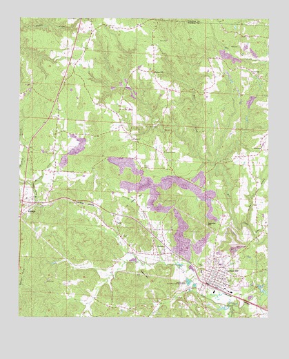
Carbon Hill, AL USGS Topographic Map
Click on map above to begin viewing in our Map Viewer.

This topographic map contains these locations and features:
Feature Name Type Latitude Longitude GNIS ID View Map
Allen CreekStreamN33.8862°W87.5375°113010View Map
Banner MineMineN33.9695°W87.5695°136004View Map
Baptist Childrens HomeBuildingN33.9251°W87.6195°142273View Map
Bible Missionary ChurchChurchN33.9440°W87.5042°163881View Map
Bynum Drift MineMineN33.8912°W87.5320°136003View Map
Camp Spring BranchStreamN33.9309°W87.6186°115478View Map
Carbon HillPopulated PlaceN33.8918°W87.5261°155010View Map
Carbon Hill Church of ChristChurchN33.8946°W87.5261°142289View Map
Carbon Hill DivisionCivilN33.9293°W87.5808°165979View Map
Carbon Hill Elementary SchoolSchoolN33.8973°W87.5245°142290View Map
Carbon Hill Grammar School (historical)SchoolN33.8921°W87.5270°142291View Map
Carbon Hill High School (historical)SchoolN33.8946°W87.5333°142292View Map
Carbon Hill Junior High SchoolSchoolN33.8973°W87.5236°142293View Map
Carbon Hill MineMineN33.8871°W87.5472°155444View Map
Carbon Hill National Fish HatcheryLocaleN33.8896°W87.5395°164300View Map
Carbon Hill Police DepartmentBuildingN33.8898°W87.5285°2752026View Map
Carbon Hill Post OfficePost OfficeN33.8908°W87.5283°2788918View Map
Carbon Hill Presbyterian ChurchChurchN33.8907°W87.5292°142294View Map
Carbon Hill Volunteer Fire DepartmentBuildingN33.8901°W87.5293°2682832View Map
Carbon Hill Volunteer Rescue SquadBuildingN33.8849°W87.5141°2683196View Map
Church of ChristChurchN33.9446°W87.5514°116126View Map
City of Carbon HillCivilN33.8944°W87.5224°2403992View Map
ClarkePopulated PlaceN33.9146°W87.5767°116186View Map
Clifty BranchStreamN33.9137°W87.5103°159417View Map
Coalbed CemeteryCemeteryN33.9376°W87.5600°116308View Map
Colburn CemeteryCemeteryN33.9454°W87.6186°163885View Map
Cranford CreekStreamN33.8796°W87.5178°116818View Map
DogtownPopulated PlaceN33.9482°W87.5667°117345View Map
Dozier CemeteryCemeteryN33.9234°W87.6242°163890View Map
EldridgePopulated PlaceN33.9229°W87.6172°117914View Map
Eldridge Church of ChristChurchN33.9229°W87.6242°142328View Map
Eldridge Gas FieldOilfieldN33.9279°W87.6083°154946View Map
Eldridge Junior High School (historical)SchoolN33.9246°W87.6211°142329View Map
Eldridge Post OfficePost OfficeN33.9226°W87.6168°2789040View Map
Eldridge Volunteer Fire DepartmentBuildingN33.9211°W87.6194°2682643View Map
Elk River Shaft MineMineN33.9265°W87.5333°136005View Map
Elliots MineMineN33.8809°W87.5278°155374View Map
First Methodist ChurchChurchN33.8918°W87.5278°142339View Map
FlatwoodPopulated PlaceN33.9451°W87.5033°118402View Map
Galloway (historical)LocaleN33.9279°W87.5445°142347View Map
Galloway Mine Number ElevenMineN33.8834°W87.5431°142349View Map
Galloway Mine Number SixMineN33.9071°W87.5325°142350View Map
Galloway MinesMineN33.9384°W87.5695°142348View Map
Gilder CreekStreamN33.8990°W87.5647°142354View Map
Grant Christian Methodist Episcopal ChapelChurchN33.8932°W87.5253°150905View Map
Guthrie MineMineN33.9743°W87.5697°155381View Map
Harris Slope MineMineN33.9346°W87.5139°155377View Map
Hope MineMineN33.9182°W87.5458°136006View Map
Hope-Galloway MineMineN33.9140°W87.5417°136007View Map
Hopewell Church (historical)ChurchN33.9954°W87.5884°142366View Map
Iron Mountain School (historical)SchoolN33.8779°W87.5814°157377View Map
Jagger Mine Number TwoMineN33.9293°W87.5570°142370View Map
Jagger MinesMineN33.9446°W87.5556°142369View Map
Jays LakeReservoirN33.8934°W87.5900°131807View Map
Jays Lake DamDamN33.8934°W87.5900°131806View Map
KansasPopulated PlaceN33.9018°W87.5520°121084View Map
Kansas Baptist ChurchChurchN33.9071°W87.5533°142379View Map
Kansas Post OfficePost OfficeN33.9017°W87.5518°2789013View Map
McGough New Slope MineMineN33.9473°W87.5208°136001View Map
Monroe MineMineN33.9762°W87.5008°155442View Map
Nauvoo MineMineN33.9751°W87.5167°136002View Map
Nauvoo Number 1 MineMineN33.9896°W87.5070°155379View Map
New Bethany ChurchChurchN33.9493°W87.5686°142397View Map
New Life Pentecostal ChurchChurchN33.8874°W87.5324°2747151View Map
Norris CemeteryCemeteryN33.9907°W87.5514°123978View Map
Old Glady BranchStreamN33.9976°W87.6103°160303View Map
Old Union Primitive Baptist ChurchChurchN33.9970°W87.5811°153771View Map
Pisgah CemeteryCemeteryN33.8976°W87.5320°124913View Map
Rabbit BranchStreamN33.9098°W87.5067°160462View Map
Radiant City ChurchChurchN33.9771°W87.5053°125403View Map
Radiant MineMineN33.9623°W87.5122°155378View Map
Seamore MountainSummitN33.9143°W87.5308°126508View Map
Shiloh CemeteryCemeteryN33.9093°W87.5731°126722View Map
Sides SchoolSchoolN33.8993°W87.5145°142435View Map
Sims CemeteryCemeteryN33.9884°W87.5156°126882View Map
Sleepy CemeteryCemeteryN33.8929°W87.5639°163914View Map
Sleepy MountainSummitN33.8918°W87.5617°126969View Map
SlicklizzardPopulated PlaceN33.9646°W87.5020°163915View Map
Spring HillPopulated PlaceN33.9776°W87.5581°157092View Map
Spring Hill CemeteryCemeteryN33.9779°W87.5642°157396View Map
Spring Hill ChurchChurchN33.9757°W87.5575°157397View Map
Spring Hill ChurchChurchN33.9782°W87.5642°142439View Map
Spring Hill School (historical)SchoolN33.9790°W87.5583°157398View Map
Standard MineMineN33.9037°W87.5325°155375View Map
Thornberry Drift MineMineN33.9112°W87.5208°135999View Map
Town of EldridgeCivilN33.9220°W87.6201°2406431View Map
Town of KansasCivilN33.9029°W87.5569°2405930View Map
Trinity CreekStreamN33.8979°W87.5520°128077View Map
Truck MineMineN33.9384°W87.5208°155376View Map
Turkey CreekStreamN33.9387°W87.5270°142448View Map
Wagon MineMineN33.9479°W87.5231°155443View Map
Walden CemeteryCemeteryN33.9548°W87.5558°128503View Map
Waldon MineMineN33.9732°W87.5678°155382View Map
Whitson Number 1 MineMineN33.9751°W87.5717°155380View Map
Yateman MinesMineN33.9279°W87.5306°142464View Map

Note: Coordinates in the location and feature list above are referenced to NAD83 datum.


Copyright (C) 2008-2025 Ryan Niemi / Sunset Dynamics ... All Rights Reserved