TopoQuest Logo
Do you find TopoQuest useful?
Help keep TopoQuest running and adding new maps/features by donating!
Bitcoin:  19c7KJd3qBynnjoSw5npx9KScwjBe4ifkT
Litecoin:  LXs6TkuXGGXo1vDsWCkWVdjQX94eUKd6ui
Home View Maps Find Maps Find Places Resources & Links


Townley, Alabama Topographic Map

USGS Map Title: Townley, AL
USGS Map MRC: 33087G4
DRG (GeoTIFF) Download: o33087g4.tif


Neighboring USGS Topographic Map Quads:


  Carbon Hill, AL  
33087H5
 

  Nauvoo, AL  
33087H4
 

  Manchester, AL  
33087H3
 

  Howard, AL  
33087G5
 

  Townley, AL  
33087G4
 

  Jasper, AL  
33087G3
 

  Berry, AL  
33087F5
 

  Oakman, AL  
33087F4
 

  Parrish, AL  
33087F3


Map MRC Location:

N34°
W88°
N34°
W87°
H8 H7 H6 H5 H4 H3 H2 H1
G8 G7 G6 G5 G4 G3 G2 G1
F8 F7 F6 F5 F4 F3 F2 F1
E8 E7 E6 E5 E4 E3 E2 E1
D8 D7 D6 D5 D4 D3 D2 D1
C8 C7 C6 C5 C4 C3 C2 C1
B8 B7 B6 B5 B4 B3 B2 B1
A8 A7 A6 A5 A4 A3 A2 A1
N33°
W88°
N33°
W87°

Townley, AL USGS 1:24K Topographic Map Preview:
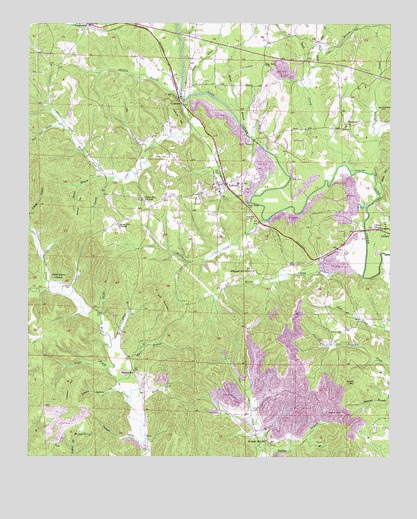
Townley, AL USGS Topographic Map
Click on map above to begin viewing in our Map Viewer.

This topographic map contains these locations and features:
Feature Name Type Latitude Longitude GNIS ID View Map
Arker MineMineN33.8001°W87.3778°135991View Map
Baker BranchStreamN33.8676°W87.3775°159102View Map
Barner HollowValleyN33.7682°W87.4592°113488View Map
Bean RiverStreamN33.8548°W87.4403°159125View Map
Beech Grove Freewill Baptist ChurchChurchN33.8018°W87.4914°113815View Map
Boshell BranchStreamN33.8309°W87.4750°114745View Map
Boshell CemeteryCemeteryN33.8315°W87.4211°142283View Map
Boshell HillSummitN33.8257°W87.4817°114746View Map
Boshells MillLocaleN33.8548°W87.4478°142284View Map
Boshells Mill DamDamN33.8568°W87.4450°131778View Map
Boshells Mill PondReservoirN33.8568°W87.4450°131777View Map
Burton CreekStreamN33.8321°W87.3814°159280View Map
CedrumPopulated PlaceN33.8515°W87.4467°115823View Map
Cedrum ChurchChurchN33.8473°W87.4428°142298View Map
Cedrum Grove ChurchChurchN33.8651°W87.4450°142299View Map
Cedrum MineMineN33.8501°W87.4125°135996View Map
Cedrum MountainSummitN33.8462°W87.4478°115824View Map
Cedrum Number 1 MineMineN33.8676°W87.4603°155373View Map
Cedrum Number 1 MineMineN33.8168°W87.4000°135992View Map
Cedrum Number 1 MineMineN33.8584°W87.4667°135998View Map
Center Hill ChurchChurchN33.8168°W87.4697°115849View Map
Cold BranchStreamN33.8623°W87.4028°159424View Map
Corona MineMineN33.7598°W87.4181°142316View Map
Downey BranchStreamN33.8537°W87.4478°117448View Map
Easly CemeteryCemeteryN33.8307°W87.4078°117732View Map
Edgil BranchStreamN33.7840°W87.4717°117867View Map
Fike and Inman CemeteryCemeteryN33.8001°W87.4372°142333View Map
First Baptist ChurchChurchN33.8293°W87.4347°163895View Map
Gum Suck HollowValleyN33.8454°W87.4900°119490View Map
Guthrie CemeteryCemeteryN33.8243°W87.4603°142454View Map
HilliardPopulated PlaceN33.8146°W87.3764°156475View Map
Holly Creek ChurchChurchN33.8412°W87.4192°142365View Map
Holly GrovePopulated PlaceN33.8387°W87.4225°120269View Map
Holly Grove MineMineN33.8418°W87.4250°135995View Map
Holly Grove Number 15 MineMineN33.8487°W87.4083°135997View Map
Horse CreekStreamN33.8023°W87.3847°120406View Map
Hurricane CreekStreamN33.8184°W87.4189°120583View Map
Jess CreekStreamN33.7982°W87.4931°120879View Map
Jim BranchStreamN33.8398°W87.4583°120888View Map
Johnny FordCrossingN33.8329°W87.3856°156534View Map
Kenney BranchStreamN33.8307°W87.4708°121155View Map
Kings CemeteryCemeteryN33.8243°W87.4078°142383View Map
Kings CemeteryCemeteryN33.8415°W87.4175°142384View Map
Kings ChapelChurchN33.8173°W87.3767°151960View Map
Langs Shaft MineMineN33.8182°W87.4264°135993View Map
Lawson CemeteryCemeteryN33.7857°W87.3922°121439View Map
Lockhart HillSummitN33.7707°W87.4853°121949View Map
Lockhart HollowValleyN33.7562°W87.4633°121950View Map
Macedonia CemeteryCemeteryN33.8454°W87.3914°142390View Map
Macedonia Church of ChristChurchN33.8454°W87.3900°152188View Map
Mammoth MineMineN33.8673°W87.3875°155372View Map
Manasco CemeteryCemeteryN33.8187°W87.4244°122242View Map
McCleskey HillSummitN33.8507°W87.3767°122476View Map
Miner BranchStreamN33.8448°W87.4258°160115View Map
Mount Zion ChurchChurchN33.7565°W87.4797°123482View Map
Myers BranchStreamN33.7715°W87.4692°123622View Map
New Hope CemeteryCemeteryN33.8634°W87.4181°152631View Map
New Hope Methodist ChurchChurchN33.8232°W87.4245°152644View Map
Palmer School (historical)SchoolN33.7746°W87.4636°124389View Map
Palmers CemeteryCemeteryN33.7801°W87.4639°142410View Map
Parsons MineMineN33.8215°W87.3806°155441View Map
Paul CreekStreamN33.8326°W87.3889°160348View Map
Payne LakeReservoirN33.8668°W87.4500°131786View Map
Pike HillSummitN33.8368°W87.4542°124723View Map
Pleasant Hill Methodist ChurchChurchN33.8037°W87.4242°152999View Map
PocahontasPopulated PlaceN33.8729°W87.4831°160420View Map
Pocahontas ChurchChurchN33.8732°W87.4820°163908View Map
Preston Guthrie HollowValleyN33.7701°W87.4686°125252View Map
Reno HillSummitN33.8196°W87.4311°125565View Map
Richard BranchStreamN33.8665°W87.3775°125603View Map
Right Fork Paul CreekStreamN33.8648°W87.3995°160490View Map
Rocky BranchStreamN33.7915°W87.4747°125804View Map
Round MountainSummitN33.7712°W87.3892°125976View Map
Stave HollowValleyN33.8290°W87.3783°127334View Map
Straight HollowValleyN33.7684°W87.4183°127449View Map
Swindle Hill ChurchChurchN33.7548°W87.4183°127601View Map
Thorn HillSummitN33.7637°W87.3936°127921View Map
Tittle BranchStreamN33.7751°W87.4728°127998View Map
TownleyPopulated PlaceN33.8290°W87.4317°153711View Map
Townley ChurchChurchN33.8243°W87.4545°142445View Map
Townley DivisionCivilN33.8491°W87.4354°165990View Map
Townley HillSummitN33.8287°W87.4417°128040View Map
Townley Junior High SchoolSchoolN33.8287°W87.4278°142446View Map
Townley MineMineN33.8112°W87.4145°155371View Map
Townley MineMineN33.8348°W87.4264°135994View Map
Townley Post OfficePost OfficeN33.8289°W87.4332°2789091View Map
Townley Volunteer Fire DepartmentBuildingN33.8282°W87.4336°2683434View Map
Union Hill ChurchChurchN33.8243°W87.4608°128342View Map
West Fork Lost CreekStreamN33.8529°W87.4453°128773View Map
West Walker Church of ChristChurchN33.8693°W87.4320°142461View Map
Wolf Creek Wildlife Management AreaParkN33.7504°W87.4997°137785View Map
Wolf MountainSummitN33.7979°W87.4567°129170View Map
Wolf Mountain MineMineN33.7918°W87.4583°135990View Map

Note: Coordinates in the location and feature list above are referenced to NAD83 datum.


Copyright (C) 2008-2025 Ryan Niemi / Sunset Dynamics ... All Rights Reserved