TopoQuest Logo
Do you find TopoQuest useful?
Help keep TopoQuest running and adding new maps/features by donating!
Bitcoin:  19c7KJd3qBynnjoSw5npx9KScwjBe4ifkT
Litecoin:  LXs6TkuXGGXo1vDsWCkWVdjQX94eUKd6ui
Home View Maps Find Maps Find Places Resources & Links


Gold Mine, Alabama Topographic Map

USGS Map Title: Gold Mine, AL
USGS Map MRC: 34087A6
DRG (GeoTIFF) Download: o34087a6.tif


Neighboring USGS Topographic Map Quads:


  Hamilton NE, AL  
34087B7
 

  Haleyville West, AL  
34087B6
 

  Haleyville East, AL  
34087B5
 

  Brilliant, AL  
34087A7
 

  Gold Mine, AL  
34087A6
 

  Lynn, AL  
34087A5
 

  Winfield, AL  
33087H7
 

  Glen Allen, AL  
33087H6
 

  Carbon Hill, AL  
33087H5


Map MRC Location:

N35°
W88°
N35°
W87°
H8 H7 H6 H5 H4 H3 H2 H1
G8 G7 G6 G5 G4 G3 G2 G1
F8 F7 F6 F5 F4 F3 F2 F1
E8 E7 E6 E5 E4 E3 E2 E1
D8 D7 D6 D5 D4 D3 D2 D1
C8 C7 C6 C5 C4 C3 C2 C1
B8 B7 B6 B5 B4 B3 B2 B1
A8 A7 A6 A5 A4 A3 A2 A1
N34°
W88°
N34°
W87°

Gold Mine, AL USGS 1:24K Topographic Map Preview:
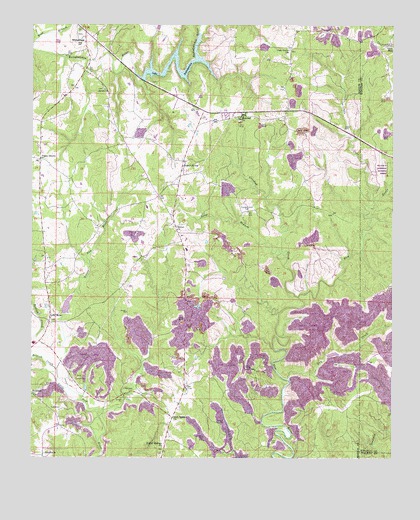
Gold Mine, AL USGS Topographic Map
Click on map above to begin viewing in our Map Viewer.

This topographic map contains these locations and features:
Feature Name Type Latitude Longitude GNIS ID View Map
Barton CemeteryCemeteryN34.1151°W87.7197°137929View Map
Bethel CemeteryCemeteryN34.0657°W87.7003°137934View Map
Bethel Church of ChristChurchN34.0668°W87.7006°114074View Map
Bostick CreekStreamN34.0254°W87.7411°114747View Map
Brilliant DivisionCivilN34.0554°W87.7282°165879View Map
Brock CemeteryCemeteryN34.1065°W87.7259°137942View Map
Brock Church of ChristChurchN34.1068°W87.7256°114936View Map
BrooksidePopulated PlaceN34.0009°W87.7453°156118View Map
Buttahatchee DamDamN34.1101°W87.7134°131938View Map
Cagle CemeteryCemeteryN34.0957°W87.6420°115360View Map
Cagle CoveValleyN34.0751°W87.6325°115361View Map
Crooked CreekStreamN34.0473°W87.6581°116881View Map
Crooked Creek CemeteryCemeteryN34.0718°W87.6764°116887View Map
Dry CreekStreamN34.0226°W87.6603°159528View Map
Goat Ranch (historical)Populated PlaceN34.0731°W87.6292°2680854View Map
Gold MinePopulated PlaceN34.0393°W87.7436°163933View Map
Gold Mine CemeteryCemeteryN34.0393°W87.7431°137979View Map
Gold Mine Church of ChristChurchN34.0404°W87.7439°154508View Map
Green CemeteryCemeteryN34.0237°W87.7264°137983View Map
Gum Springs ChurchChurchN34.0118°W87.7009°119488View Map
Halcomb CemeteryCemeteryN34.0195°W87.7145°119553View Map
Haley CemeteryCemeteryN34.1198°W87.7350°154459View Map
Lake ButtahatcheeLakeN34.1137°W87.6996°115324View Map
Little New River Lake Number 3ReservoirN34.0384°W87.7384°131912View Map
Little New River Lake Number 3 DamDamN34.0384°W87.7384°131913View Map
Long BranchStreamN34.0595°W87.6639°121990View Map
Magic Post Office (historical)Post OfficeN34.0678°W87.6350°167137View Map
Miles CemeteryCemeteryN34.0048°W87.6667°152318View Map
Myers Hill Baptist ChurchChurchN34.0990°W87.6789°153217View Map
Myers Hill CemeteryCemeteryN34.0982°W87.6781°138024View Map
Oak Grove CemeteryCemeteryN34.1184°W87.6609°138036View Map
Oak Grove Church of ChristChurchN34.1184°W87.6617°152737View Map
Old Mars Hill CemeteryCemeteryN34.0829°W87.7184°138039View Map
Old Poplar Springs CemeteryCemeteryN34.0032°W87.7050°138040View Map
Old Poplar Springs Primitive Baptist ChurchChurchN34.0032°W87.7045°153044View Map
Pine Grove ChurchChurchN34.0882°W87.7478°154509View Map
Piney GrovePopulated PlaceN34.0859°W87.7475°156901View Map
Potts CemeteryCemeteryN34.1093°W87.6900°138055View Map
Rowell CemeteryCemeteryN34.0169°W87.6391°142006View Map
Sunny HomePopulated PlaceN34.0843°W87.6992°127560View Map
Sunny Home Volunteer Fire DepartmentBuildingN34.0837°W87.6976°2683384View Map
West Branch Buttahatchee RiverStreamN34.1207°W87.7486°128756View Map
WhitehousePopulated PlaceN34.1215°W87.7322°128900View Map
Whitehouse CemeteryCemeteryN34.1223°W87.7347°138086View Map
Whitehouse Gas Field (historical)OilfieldN34.1048°W87.7181°154953View Map

Note: Coordinates in the location and feature list above are referenced to NAD83 datum.


Copyright (C) 2008-2025 Ryan Niemi / Sunset Dynamics ... All Rights Reserved