TopoQuest Logo
Do you find TopoQuest useful?
Help keep TopoQuest running and adding new maps/features by donating!
Bitcoin:  19c7KJd3qBynnjoSw5npx9KScwjBe4ifkT
Litecoin:  LXs6TkuXGGXo1vDsWCkWVdjQX94eUKd6ui
Home View Maps Find Maps Find Places Resources & Links


Waveland, Mississippi Topographic Map

USGS Map Title: Waveland, MS
USGS Map MRC: 30089C4
DRG (GeoTIFF) Download: o30089c4.tif


Neighboring USGS Topographic Map Quads:


  Dead Tiger Creek, MS  
30089D5
 

  Kiln, MS  
30089D4
 

  Dedeaux, MS  
30089D3
 

  Logtown, MS  
30089C5
 

  Waveland, MS  
30089C4
 

  Bay Saint Louis, MS  
30089C3
 

  English Lookout, LA  
30089B5
 

  Saint Joe Pass, MS  
30089B4


Map MRC Location:

N31°
W90°
N31°
W89°
H8 H7 H6 H5 H4 H3 H2 H1
G8 G7 G6 G5 G4 G3 G2 G1
F8 F7 F6 F5 F4 F3 F2 F1
E8 E7 E6 E5 E4 E3 E2 E1
D8 D7 D6 D5 D4 D3 D2 D1
C8 C7 C6 C5 C4 C3 C2 C1
B8 B7 B6 B5 B4 B3 B2 B1
A8 A7 A6 A5 A4 A3 A2 A1
N30°
W90°
N30°
W89°

Waveland, MS USGS 1:24K Topographic Map Preview:
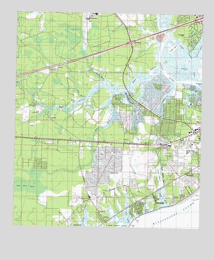
Waveland, MS USGS Topographic Map
Click on map above to begin viewing in our Map Viewer.

This topographic map contains these locations and features:
Feature Name Type Latitude Longitude GNIS ID View Map
Bay Hide Away Recreational Vehicle Park and CampgroundLocaleN30.2919°W89.4535°2596383View Map
Bay MarinaLocaleN30.3235°W89.3818°2596519View Map
Bay Marina Recreational Vehicle ParkLocaleN30.3221°W89.3827°2597026View Map
Bay Saint Louis Fire Department Station 2BuildingN30.3193°W89.3799°2332736View Map
Bay Side Volunteer Fire DepartmentBuildingN30.2927°W89.4414°2332742View Map
Bayou L' EncienteStreamN30.3585°W89.4028°689401View Map
Bayou la Croix Boat RampLocaleN30.3296°W89.4243°2596520View Map
Bayou LacroixStreamN30.3444°W89.4039°666607View Map
Bayou MaroneStreamN30.3358°W89.4412°666610View Map
Bayou PhilipStreamN30.3296°W89.4351°666611View Map
Bayside Baptist ChurchChurchN30.2828°W89.4399°2596106View Map
Bayside ParkPopulated PlaceN30.2827°W89.4367°666620View Map
Breath BayouGutN30.3274°W89.3992°667536View Map
Buccaneer State ParkParkN30.2613°W89.4042°689392View Map
Cameron IslandIslandN30.3335°W89.3756°667960View Map
Catfish BayouGutN30.3421°W89.3831°668158View Map
Church of the Living GodChurchN30.2819°W89.3950°2596242View Map
City of WavelandCivilN30.2931°W89.3905°2405691View Map
Clermont HarborPopulated PlaceN30.2616°W89.4162°668599View Map
Clermont Harbor SchoolSchoolN30.2630°W89.4148°689398View Map
Clermont Harbor Volunteer Fire DepartmentBuildingN30.2658°W89.4174°2332750View Map
Cutoff BayouGutN30.3513°W89.3881°669035View Map
Cutoff LakeLakeN30.3562°W89.3954°669037View Map
Diamondhead AirportAirportN30.3604°W89.3876°680290View Map
Diamondhead Tennis WorldBuildingN30.3701°W89.3936°2597052View Map
Edwards BayouStreamN30.3313°W89.3764°669684View Map
Edwards School (historical)SchoolN30.3224°W89.3853°690045View Map
Elwood Memorial ParkParkN30.2799°W89.3875°689400View Map
Fairview CampgroundLocaleN30.2672°W89.4049°2596553View Map
First Baptist ChurchChurchN30.2896°W89.3762°689404View Map
Four Dollar BayouGutN30.3230°W89.4245°670126View Map
Grand BayouStreamN30.2627°W89.3964°670576View Map
Gulf View SchoolSchoolN30.2669°W89.4492°670770View Map
GulfsidePopulated PlaceN30.2669°W89.3925°690046View Map
Gum BranchStreamN30.3249°W89.4534°670783View Map
Hancock County FairgroundsLocaleN30.3149°W89.3809°689406View Map
Hancock County Sheriff's OfficeBuildingN30.3032°W89.4764°2332871View Map
Holy Cross Boys CampLocaleN30.2680°W89.3931°671366View Map
Interchange 13CrossingN30.3585°W89.4231°691347View Map
Interchange 16CrossingN30.3727°W89.3770°691348View Map
Interstate 10 East Roadside ParkLocaleN30.3430°W89.4735°2596309View Map
Jackson MarshLakeN30.2800°W89.4023°671783View Map
Jackson RidgeRidgeN30.2671°W89.4056°671787View Map
Jones Mill (historical)LocaleN30.3408°W89.4050°689411View Map
Lakeshore Baptist ChurchChurchN30.2549°W89.4389°2596516View Map
Little Zion Baptist ChurchChurchN30.2789°W89.3905°2596371View Map
Lutheran Church of the PinesChurchN30.3044°W89.3814°689415View Map
Macedonia Missionary Baptist ChurchChurchN30.2854°W89.3829°2596372View Map
Mount Chapel Baptist ChurchChurchN30.2866°W89.3893°2597151View Map
Mud BayouSwampN30.2610°W89.4099°674425View Map
Saint Anns and Saint Johns Catholic ChurchChurchN30.2755°W89.4235°2596107View Map
Saint Anns Catholic ChurchChurchN30.2619°W89.4184°689423View Map
Saint Johns ChurchChurchN30.2599°W89.4437°677077View Map
Sand BayouGutN30.2566°W89.4239°677322View Map
Shoreline ParkPopulated PlaceN30.3182°W89.4093°2407602View Map
Shoreline Park Baptist ChurchChurchN30.3149°W89.4076°2596108View Map
Shoreline Park Census Designated PlaceCensusN30.3191°W89.4094°2402851View Map
Spanish Trail ChurchChurchN30.2991°W89.4128°678037View Map
Stennis International AirportAirportN30.3726°W89.4523°680291View Map
Stennis International Airport Aircraft Rescue Fire FightingBuildingN30.3730°W89.4514°2668016View Map
The Church of Jesus Christ of Latter Day SaintsChurchN30.3030°W89.3763°2597153View Map
Turkey Bayou AirparkAirportN30.2506°W89.4587°2676416View Map
Umbrella BayouStreamN30.3502°W89.3806°679023View Map
WavelandPopulated PlaceN30.2869°W89.3762°679394View Map
Waveland Elementary SchoolSchoolN30.2996°W89.3809°689513View Map
Waveland Fire Department Central StationBuildingN30.3045°W89.3815°2332756View Map
Waveland United Methodist ChurchChurchN30.2844°W89.3806°689439View Map

Note: Coordinates in the location and feature list above are referenced to NAD83 datum.


Copyright (C) 2008-2025 Ryan Niemi / Sunset Dynamics ... All Rights Reserved