TopoQuest Logo
Do you find TopoQuest useful?
Help keep TopoQuest running and adding new maps/features by donating!
Bitcoin:  19c7KJd3qBynnjoSw5npx9KScwjBe4ifkT
Litecoin:  LXs6TkuXGGXo1vDsWCkWVdjQX94eUKd6ui
Home View Maps Find Maps Find Places Resources & Links


Dead Tiger Creek, Mississippi Topographic Map

USGS Map Title: Dead Tiger Creek, MS
USGS Map MRC: 30089D5
DRG (GeoTIFF) Download: o30089d5.tif


Neighboring USGS Topographic Map Quads:


  Picayune, MS  
30089E6
 

  Caesar, MS  
30089E5
 

  Necaise, MS  
30089E4
 

  Nicholson, MS  
30089D6
 

  Dead Tiger Creek, MS  
30089D5
 

  Kiln, MS  
30089D4
 

  Haaswood, LA  
30089C6
 

  Logtown, MS  
30089C5
 

  Waveland, MS  
30089C4


Map MRC Location:

N31°
W90°
N31°
W89°
H8 H7 H6 H5 H4 H3 H2 H1
G8 G7 G6 G5 G4 G3 G2 G1
F8 F7 F6 F5 F4 F3 F2 F1
E8 E7 E6 E5 E4 E3 E2 E1
D8 D7 D6 D5 D4 D3 D2 D1
C8 C7 C6 C5 C4 C3 C2 C1
B8 B7 B6 B5 B4 B3 B2 B1
A8 A7 A6 A5 A4 A3 A2 A1
N30°
W90°
N30°
W89°

Dead Tiger Creek, MS USGS 1:24K Topographic Map Preview:
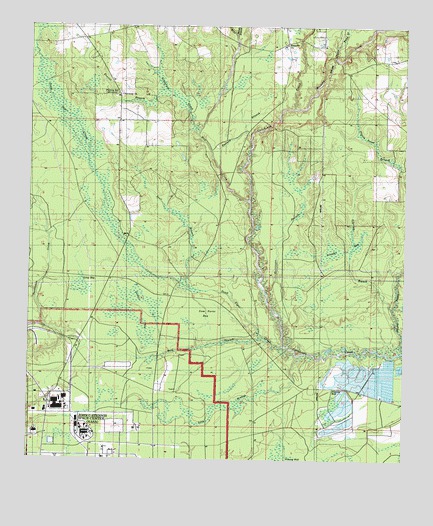
Dead Tiger Creek, MS USGS Topographic Map
Click on map above to begin viewing in our Map Viewer.

This topographic map contains these locations and features:
Feature Name Type Latitude Longitude GNIS ID View Map
Adgreen BranchStreamN30.4185°W89.5039°666159View Map
Bayou BaconStreamN30.4066°W89.5009°666595View Map
Bienville ChurchChurchN30.4949°W89.5398°667070View Map
Catahoula CreekStreamN30.4063°W89.5009°668154View Map
Catfish Ponds Lake DamDamN30.4002°W89.5034°680441View Map
Crabgrass CreekStreamN30.4696°W89.5689°668923View Map
Crane Pond BranchStreamN30.4913°W89.5239°668930View Map
Dead Tiger CreekStreamN30.4080°W89.5401°669169View Map
Dead Tiger School (historical)SchoolN30.4274°W89.5995°690044View Map
Double BaySwampN30.4180°W89.5870°669341View Map
Everett BranchStreamN30.4813°W89.5792°669844View Map
Flat TopPopulated PlaceN30.4799°W89.5956°710453View Map
Flattop SchoolLocaleN30.4802°W89.5959°670031View Map
Fletcher Lake DamDamN30.3902°W89.5217°680439View Map
Harmony ChurchChurchN30.4802°W89.5948°670933View Map
Hickory CreekStreamN30.4763°W89.5378°671152View Map
Hurricane BranchStreamN30.4230°W89.5459°671601View Map
John C Stennis Space CenterReserveN30.3798°W89.6025°705668View Map
Josephs BaySwampN30.4355°W89.5198°672036View Map
Lion BranchStreamN30.4049°W89.5356°672524View Map
Long BaySwampN30.4255°W89.6084°672792View Map
Mill CreekStreamN30.4499°W89.5517°673613View Map
Mississippi Army Ammunition PlantMilitaryN30.3967°W89.6087°2512432View Map
Pasture BranchStreamN30.4588°W89.5620°675485View Map
Sam Farve BayFlatN30.4171°W89.5656°677309View Map
Shrub BranchStreamN30.4971°W89.5564°677755View Map
Stall BranchStreamN30.4241°W89.5709°678205View Map
Wolf BranchStreamN30.4091°W89.5456°679803View Map

Note: Coordinates in the location and feature list above are referenced to NAD83 datum.


Copyright (C) 2008-2025 Ryan Niemi / Sunset Dynamics ... All Rights Reserved