TopoQuest Logo
Do you find TopoQuest useful?
Help keep TopoQuest running and adding new maps/features by donating!
Bitcoin:  19c7KJd3qBynnjoSw5npx9KScwjBe4ifkT
Litecoin:  LXs6TkuXGGXo1vDsWCkWVdjQX94eUKd6ui
Home View Maps Find Maps Find Places Resources & Links


Carthage, Mississippi Topographic Map

USGS Map Title: Carthage, MS
USGS Map MRC: 32089F5
DRG (GeoTIFF) Download: o32089f5.tif


Neighboring USGS Topographic Map Quads:


  Thomastown, MS  
32089G6
 

  Conway, MS  
32089G5
 

  Renfroe, MS  
32089G4
 

  Ofahoma, MS  
32089F6
 

  Carthage, MS  
32089F5
 

  McAfee, MS  
32089F4
 

  Ludlow, MS  
32089E6
 

  Lena, MS  
32089E5
 

  Walnut Grove, MS  
32089E4


Map MRC Location:

N33°
W90°
N33°
W89°
H8 H7 H6 H5 H4 H3 H2 H1
G8 G7 G6 G5 G4 G3 G2 G1
F8 F7 F6 F5 F4 F3 F2 F1
E8 E7 E6 E5 E4 E3 E2 E1
D8 D7 D6 D5 D4 D3 D2 D1
C8 C7 C6 C5 C4 C3 C2 C1
B8 B7 B6 B5 B4 B3 B2 B1
A8 A7 A6 A5 A4 A3 A2 A1
N32°
W90°
N32°
W89°

Carthage, MS USGS 1:24K Topographic Map Preview:
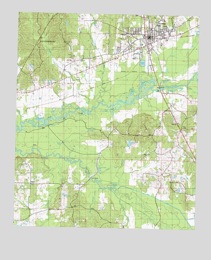
Carthage, MS USGS Topographic Map
Click on map above to begin viewing in our Map Viewer.

This topographic map contains these locations and features:
Feature Name Type Latitude Longitude GNIS ID View Map
Adair LakeLakeN32.6935°W89.5644°666144View Map
Babb BranchStreamN32.6482°W89.5667°692435View Map
Balucta CreekStreamN32.6657°W89.5962°711186View Map
Beaver PondLakeN32.6662°W89.5898°666718View Map
Black LakeLakeN32.6740°W89.5959°667234View Map
Bully BayouSwampN32.7051°W89.5429°691079View Map
CarthagePopulated PlaceN32.7326°W89.5362°668123View Map
Carthage Attendance CenterSchoolN32.7449°W89.5278°707068View Map
Carthage Elementary SchoolSchoolN32.7418°W89.5334°707069View Map
Carthage Female Academy (historical)SchoolN32.7418°W89.5331°707070View Map
Carthage Junior High SchoolSchoolN32.7387°W89.5528°691146View Map
Carthage Junior High SchoolSchoolN32.7387°W89.5506°707071View Map
Carthage Police DepartmentBuildingN32.7370°W89.5362°2754164View Map
Carthage Post OfficePost OfficeN32.7379°W89.5348°2768630View Map
Carthage Presbyterian ChurchChurchN32.7399°W89.5331°707072View Map
Carthage Sewage Lagoon DamDamN32.7201°W89.5384°681602View Map
Carthage United Methodist ChurchChurchN32.7379°W89.5337°685001View Map
Cedar Grove Baptist ChurchChurchN32.6504°W89.6140°707073View Map
Cedar Grove CemeteryCemeteryN32.6497°W89.6137°707074View Map
Cedar Grove ChurchChurchN32.6501°W89.6137°691078View Map
Cedar Grove School (historical)SchoolN32.6499°W89.6140°707075View Map
City of CarthageCivilN32.7431°W89.5337°2404004View Map
Coles Ford LakeLakeN32.6989°W89.5646°668688View Map
Creal Field BranchStreamN32.6682°W89.5762°668939View Map
Crowder CreekStreamN32.6307°W89.5053°668990View Map
Deal IslandIslandN32.6965°W89.5567°669172View Map
Deep LakeLakeN32.6524°W89.5674°669192View Map
Dry BranchStreamN32.6649°W89.5909°669401View Map
Duck Pond SloughLakeN32.6492°W89.5557°669478View Map
Dumas Cemetery (historical)CemeteryN32.6649°W89.6098°691140View Map
First Baptist ChurchChurchN32.7387°W89.5351°707090View Map
Flatwood LakeLakeN32.6847°W89.6040°670032View Map
GillPopulated PlaceN32.6796°W89.5317°691885View Map
Government HillsRangeN32.7404°W89.6248°670557View Map
Grover Grimes Catfish Ponds DamDamN32.6501°W89.5101°681558View Map
Hanson LakeLakeN32.7075°W89.5132°670888View Map
Horseshoe LakeLakeN32.6882°W89.6126°671497View Map
Joe Neal LakeLakeN32.7103°W89.5230°671889View Map
Jones ChapelChurchN32.6682°W89.5348°671979View Map
Jordan LakeLakeN32.6817°W89.5746°672028View Map
Kermit Daughterly Lake DamDamN32.7401°W89.5001°681615View Map
Langston LakeLakeN32.7065°W89.5166°672302View Map
Leake County Correctional FacilityBuildingN32.7334°W89.5231°2739804View Map
Leake County Memorial HospitalHospitalN32.7414°W89.5188°707115View Map
Leake County Sheriff's OfficeBuildingN32.7343°W89.5231°2754251View Map
McFaddens Ferry (historical)CrossingN32.7315°W89.5362°685005View Map
McMillian ParkParkN32.7340°W89.5259°673405View Map
Mount Horeb Church (historical)ChurchN32.6721°W89.5165°691155View Map
Mount Zion Presbyterian Church (historical)ChurchN32.6276°W89.5501°707128View Map
Peach Tree IslandIslandN32.6918°W89.5804°675531View Map
Pellaphalia CreekStreamN32.6976°W89.5695°675580View Map
PiggtownPopulated PlaceN32.6499°W89.6159°675728View Map
Pilgrim RestPopulated PlaceN32.7246°W89.5876°707134View Map
Pilgrim Rest CemeteryCemeteryN32.7251°W89.5878°707135View Map
Pilgrim Rest ChurchChurchN32.7257°W89.5904°675750View Map
Pilgrim Rest School (historical)SchoolN32.7260°W89.5881°707137View Map
Pleasant Hill CemeteryCemeteryN32.6793°W89.5417°707139View Map
Pleasant Hill ChurchChurchN32.6796°W89.5423°676070View Map
Pleasant Hill School (historical)SchoolN32.6796°W89.5417°707140View Map
Pollard CreekStreamN32.7115°W89.5317°676185View Map
Popular Ridge LakeLakeN32.6587°W89.5668°676249View Map
Pottock CreekStreamN32.7093°W89.5084°676281View Map
Saint Ann Catholic ChurchChurchN32.7468°W89.5362°707152View Map
Supervisor District 4CivilN32.6427°W89.5666°711951View Map
Sweetwater CreekStreamN32.6471°W89.5590°694921View Map
Town CreekStreamN32.7110°W89.5351°678839View Map
Trinity Baptist ChurchChurchN32.7396°W89.5203°685007View Map
Tuckers CrossingPopulated PlaceN32.6540°W89.5740°692279View Map
WECP-AM (Carthage)TowerN32.7204°W89.5467°680120View Map
Witt CreekStreamN32.6862°W89.6242°679799View Map
WWYN-FM (Carthage)TowerN32.7204°W89.5467°680226View Map
Yellow CreekStreamN32.6957°W89.5737°679938View Map

Note: Coordinates in the location and feature list above are referenced to NAD83 datum.


Copyright (C) 2008-2024 Ryan Niemi / Sunset Dynamics ... All Rights Reserved