TopoQuest Logo
Do you find TopoQuest useful?
Help keep TopoQuest running and adding new maps/features by donating!
Bitcoin:  19c7KJd3qBynnjoSw5npx9KScwjBe4ifkT
Litecoin:  LXs6TkuXGGXo1vDsWCkWVdjQX94eUKd6ui
Home View Maps Find Maps Find Places Resources & Links


Casemore, Alabama Topographic Map

USGS Map Title: Casemore, AL
USGS Map MRC: 32087E6
DRG (GeoTIFF) Download: o32087e6.tif


Neighboring USGS Topographic Map Quads:


  Mason Bend, AL  
32087F7
 

  Melton, AL  
32087F6
 

  Greensboro, AL  
32087F5
 

  Demopolis, AL  
32087E7
 

  Casemore, AL  
32087E6
 

  Newbern, AL  
32087E5
 

  Old Spring Hill, AL  
32087D7
 

  Gallion, AL  
32087D6
 

  Uniontown West, AL  
32087D5


Map MRC Location:

N33°
W88°
N33°
W87°
H8 H7 H6 H5 H4 H3 H2 H1
G8 G7 G6 G5 G4 G3 G2 G1
F8 F7 F6 F5 F4 F3 F2 F1
E8 E7 E6 E5 E4 E3 E2 E1
D8 D7 D6 D5 D4 D3 D2 D1
C8 C7 C6 C5 C4 C3 C2 C1
B8 B7 B6 B5 B4 B3 B2 B1
A8 A7 A6 A5 A4 A3 A2 A1
N32°
W88°
N32°
W87°

Casemore, AL USGS 1:24K Topographic Map Preview:
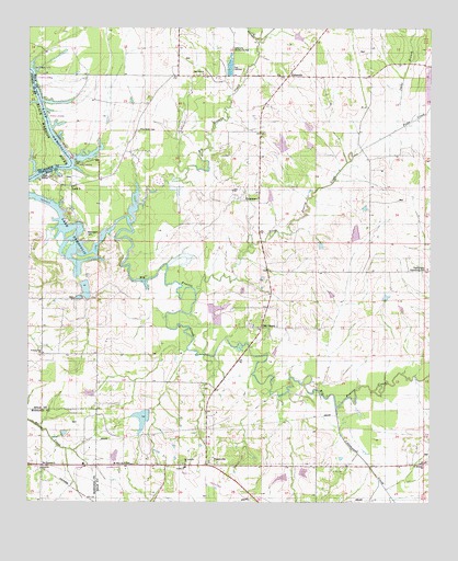
Casemore, AL USGS Topographic Map
Click on map above to begin viewing in our Map Viewer.

This topographic map contains these locations and features:
Feature Name Type Latitude Longitude GNIS ID View Map
Big German CreekStreamN32.5740°W87.7183°114281View Map
Candys LandingLocaleN32.5899°W87.7356°138957View Map
CasemorePopulated PlaceN32.5804°W87.6839°115682View Map
Casemore CemeteryCemeteryN32.5826°W87.6867°158560View Map
Casemore School (historical)SchoolN32.5818°W87.6833°138958View Map
CedarvillePopulated PlaceN32.6126°W87.6695°156160View Map
Cedarville Community HallLocaleN32.6199°W87.6867°115821View Map
Cottonwood CreekStreamN32.5251°W87.6539°155040View Map
Drakes LandingLocaleN32.6010°W87.7431°138969View Map
Drakes Landing Ferry (historical)CrossingN32.6010°W87.7431°138970View Map
Dunlap Landing (historical)LocaleN32.5879°W87.7436°132530View Map
Eaton CemeteryCemeteryN32.6010°W87.7017°149464View Map
Emory School (historical)SchoolN32.6129°W87.6972°138974View Map
Evening Star CemeteryCemeteryN32.5404°W87.7464°158562View Map
Evening Star ChurchChurchN32.5393°W87.7450°118077View Map
Evening Star School (historical)SchoolN32.5399°W87.7453°138977View Map
Fitzgerald LakeReservoirN32.5301°W87.7117°130665View Map
Gallion Baptist ChurchChurchN32.5096°W87.7008°151786View Map
Gallion Post OfficePost OfficeN32.5101°W87.6991°168597View Map
Gallion Volunteer Fire DepartmentBuildingN32.5101°W87.7059°2691375View Map
Jacks BranchStreamN32.5979°W87.6367°120752View Map
Johnson Cane Brake Church (historical)ChurchN32.5765°W87.6445°139003View Map
Lewis Lawson DamDamN32.6001°W87.7333°130762View Map
Lewis Lawson PondReservoirN32.6001°W87.7333°130761View Map
Little German CreekStreamN32.6215°W87.6781°121793View Map
Little Prairie CreekStreamN32.5549°W87.6978°121851View Map
Lock 5 School (historical)SchoolN32.5932°W87.7195°139010View Map
Lock FivePopulated PlaceN32.5832°W87.7367°121938View Map
Lock Number Five Left Bank Public Use AreaParkN32.5871°W87.7436°166084View Map
M J Fitzgerald DamDamN32.5301°W87.7117°130664View Map
Mars Hill ChurchChurchN32.6129°W87.6956°122296View Map
Mars Hill ChurchChurchN32.5982°W87.7164°149469View Map
Mary Grote Church (historical)ChurchN32.5971°W87.6470°139015View Map
Micken CemeteryCemeteryN32.6046°W87.7000°159034View Map
Mount Olive Baptist ChurchChurchN32.5104°W87.7195°123304View Map
Mount Olive CemeteryCemeteryN32.5104°W87.7194°158580View Map
Mount Pleasant ChurchChurchN32.5099°W87.7453°123365View Map
Newbern DivisionCivilN32.5442°W87.6414°165793View Map
Oak GrovePopulated PlaceN32.5462°W87.6775°124058View Map
Oak Grove Baptist ChurchChurchN32.5462°W87.6800°139031View Map
Oak Grove CemeteryCemeteryN32.5465°W87.6806°1805632View Map
Oak Grove School (historical)SchoolN32.5468°W87.6797°139032View Map
Old Lock Number Five (historical)LocaleN32.5862°W87.7439°139033View Map
Old Tindells Ferry (historical)CrossingN32.6129°W87.7495°132670View Map
Pickens CemeteryCemeteryN32.6154°W87.7456°149471View Map
Picks CreekStreamN32.5979°W87.6367°124701View Map
Pine Grove CemeteryCemeteryN32.5982°W87.7158°124777View Map
Praine Chapel (historical)ChurchN32.6204°W87.6617°139046View Map
Prairie Eden Community HallLocaleN32.5615°W87.6261°125238View Map
PrairievillePopulated PlaceN32.5101°W87.6945°156931View Map
Rosenwald School (historical)SchoolN32.5390°W87.7461°139049View Map
Saint Andrews CemeteryCemeteryN32.5104°W87.7014°139051View Map
Saint Andrews ChurchChurchN32.5092°W87.7008°2492260View Map
Saint Andrews ChurchChurchN32.5092°W87.7008°139052View Map
Saint Michaels ChurchChurchN32.5101°W87.6270°126173View Map
Saint Michaels School (historical)SchoolN32.5104°W87.6258°139055View Map
Tindells BarBarN32.6126°W87.7492°132725View Map
Tindells LandingLocaleN32.6129°W87.7478°139073View Map
Union Chapel (historical)ChurchN32.6121°W87.7053°139074View Map
Washington CemeteryCemeteryN32.5704°W87.7319°128608View Map
Willis-Scott CemeteryCemeteryN32.5518°W87.6783°149477View Map
Zion ChurchChurchN32.5824°W87.6864°154061View Map

Note: Coordinates in the location and feature list above are referenced to NAD83 datum.


Copyright (C) 2008-2025 Ryan Niemi / Sunset Dynamics ... All Rights Reserved