TopoQuest Logo
Do you find TopoQuest useful?
Help keep TopoQuest running and adding new maps/features by donating!
Bitcoin:  19c7KJd3qBynnjoSw5npx9KScwjBe4ifkT
Litecoin:  LXs6TkuXGGXo1vDsWCkWVdjQX94eUKd6ui
Home View Maps Find Maps Find Places Resources & Links


Cassells-Boykin Park, Texas Topographic Map

USGS Map Title: Cassells-Boykin Park, TX
USGS Map MRC: 31094B3
DRG (GeoTIFF) Download: o31094b3.tif


Neighboring USGS Topographic Map Quads:


  Etoile South, TX  
31094C4
 

  Broaddus, TX  
31094C3
 

  Harvey Creek, TX  
31094C2
 

  Zavalla, TX  
31094B4
 

  Cassells-Boykin Park, TX  
31094B3
 

  Veach, TX  
31094B2
 

  Rockland, TX  
31094A4
 

  Boykin Spring, TX  
31094A3
 

  Ebenezer, TX  
31094A2


Map MRC Location:

N32°
W95°
N32°
W94°
H8 H7 H6 H5 H4 H3 H2 H1
G8 G7 G6 G5 G4 G3 G2 G1
F8 F7 F6 F5 F4 F3 F2 F1
E8 E7 E6 E5 E4 E3 E2 E1
D8 D7 D6 D5 D4 D3 D2 D1
C8 C7 C6 C5 C4 C3 C2 C1
B8 B7 B6 B5 B4 B3 B2 B1
A8 A7 A6 A5 A4 A3 A2 A1
N31°
W95°
N31°
W94°

Cassells-Boykin Park, TX USGS 1:24K Topographic Map Preview:
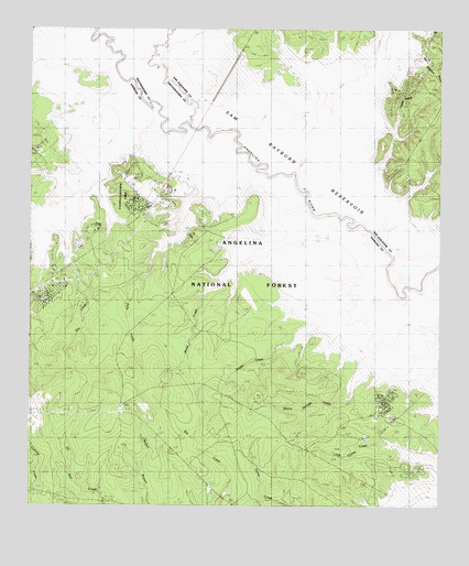
Cassells-Boykin Park, TX USGS Topographic Map
Click on map above to begin viewing in our Map Viewer.

This topographic map contains these locations and features:
Feature Name Type Latitude Longitude GNIS ID View Map
Angelina National ForestForestN31.2228°W94.2950°1381321View Map
Bayou Springs CreekStreamN31.1807°W94.2596°1381368View Map
Blackbum BranchStreamN31.2413°W94.2552°1383685View Map
Boggy CreekStreamN31.1799°W94.2691°1381478View Map
Boykin CemeteryCemeteryN31.2085°W94.3502°1381500View Map
Brushy CreekStreamN31.1810°W94.2624°1381531View Map
Caney Creek Recreation SiteLocaleN31.1341°W94.2577°1383640View Map
Cassell Boykin Park Recreation SiteLocaleN31.2138°W94.3469°1383645View Map
Cassells-Boykin ParkParkN31.2041°W94.3380°1383747View Map
Cassels CemeteryCemeteryN31.2099°W94.3360°1381605View Map
Concord CemeteryCemeteryN31.1502°W94.3474°1383638View Map
Concord ChurchChurchN31.1507°W94.3474°1383643View Map
Dry CreekStreamN31.1849°W94.3613°1383642View Map
Franklin BranchStreamN31.2246°W94.2763°1381895View Map
Harvey CemeteryCemeteryN31.2494°W94.2710°1381975View Map
Harvey CreekStreamN31.2135°W94.2941°1381978View Map
Harvey Creek Recreation SiteLocaleN31.2132°W94.2649°1383641View Map
Hog BranchStreamN31.2388°W94.2713°1382008View Map
Indian CreekStreamN31.2130°W94.2944°1382061View Map
Julia CreekStreamN31.1853°W94.3417°1382098View Map
Little Caney CreekStreamN31.1419°W94.2680°1383639View Map
Miller CemeteryCemeteryN31.2310°W94.2652°1382302View Map
Monterey Boat RampLocaleN31.2127°W94.3716°1383644View Map
Monterey Park CampgroundLocaleN31.2135°W94.3696°1383648View Map
Mott CemeteryCemeteryN31.2074°W94.3283°1382332View Map
Mudd CreekStreamN31.2030°W94.2896°1382362View Map
Pophers CreekStreamN31.2260°W94.3355°1382553View Map
Rayburn BranchStreamN31.2374°W94.2705°1382601View Map
Rayburn CemeteryCemeteryN31.2385°W94.2583°1382602View Map
Rocky CreekStreamN31.2005°W94.3691°1382643View Map
Runnels CemeteryCemeteryN31.1707°W94.2610°1382659View Map
Runnels CemeteryCemeteryN31.2105°W94.2630°1382660View Map
Warsaw (historical)LocaleN31.2449°W94.3321°1381291View Map
Zavalla DivisionCivilN31.1402°W94.3556°1939345View Map

Note: Coordinates in the location and feature list above are referenced to NAD83 datum.


Copyright (C) 2008-2024 Ryan Niemi / Sunset Dynamics ... All Rights Reserved