TopoQuest Logo
Do you find TopoQuest useful?
Help keep TopoQuest running and adding new maps/features by donating!
Bitcoin:  19c7KJd3qBynnjoSw5npx9KScwjBe4ifkT
Litecoin:  LXs6TkuXGGXo1vDsWCkWVdjQX94eUKd6ui
Home View Maps Find Maps Find Places Resources & Links


Campaign, Tennessee Topographic Map

USGS Map Title: Campaign, TN
USGS Map MRC: 35085G6
DRG (GeoTIFF) Download: o35085g6.tif


Neighboring USGS Topographic Map Quads:


  Smithville, TN  
35085H7
 

  Sligo Bridge, TN  
35085H6
 

  Cassville, TN  
35085H5
 

  Dibrell, TN  
35085G7
 

  Campaign, TN  
35085G6
 

  Doyle, TN  
35085G5
 

  McMinnville, TN  
35085F7
 

  Cardwell Mountain, TN  
35085F6
 

  Welchland, TN  
35085F5


Map MRC Location:

N36°
W86°
N36°
W85°
H8 H7 H6 H5 H4 H3 H2 H1
G8 G7 G6 G5 G4 G3 G2 G1
F8 F7 F6 F5 F4 F3 F2 F1
E8 E7 E6 E5 E4 E3 E2 E1
D8 D7 D6 D5 D4 D3 D2 D1
C8 C7 C6 C5 C4 C3 C2 C1
B8 B7 B6 B5 B4 B3 B2 B1
A8 A7 A6 A5 A4 A3 A2 A1
N35°
W86°
N35°
W85°

Campaign, TN USGS 1:24K Topographic Map Preview:
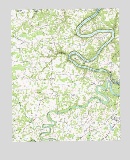
Campaign, TN USGS Topographic Map
Click on map above to begin viewing in our Map Viewer.

This topographic map contains these locations and features:
Feature Name Type Latitude Longitude GNIS ID View Map
AntiochPopulated PlaceN35.8573°W85.7169°1314589View Map
Antioch School (historical)SchoolN35.8578°W85.7169°1322508View Map
Bailiff Old Ferry (historical)CrossingN35.8278°W85.6828°1311851View Map
Bain CemeteryCemeteryN35.8731°W85.6744°1313842View Map
Barren CreekStreamN35.8317°W85.6833°1276378View Map
Barton CreekStreamN35.8301°W85.6991°1304978View Map
BelkPopulated PlaceN35.8426°W85.6994°1314657View Map
Belk School (historical)SchoolN35.8437°W85.6933°1322510View Map
BereaPopulated PlaceN35.8090°W85.7044°1314665View Map
Berea Church of ChristChurchN35.8078°W85.7053°1646730View Map
Blue HoleBayN35.8140°W85.6364°1277760View Map
CambridgePopulated PlaceN35.7931°W85.6958°1314788View Map
Camp OvertonLocaleN35.7973°W85.6414°1279406View Map
CampaignPopulated PlaceN35.7709°W85.6286°1305638View Map
Campaign - Rock Island Volunteer Fire DepartmentBuildingN35.7693°W85.6318°2654311View Map
Campaign ChurchChurchN35.7742°W85.6316°1279418View Map
Campaign Division (historical)CensusN35.7526°W85.6550°1648995View Map
Campaign Post OfficePost OfficeN35.7697°W85.6320°1651489View Map
Cantrell CemeteryCemeteryN35.8403°W85.6483°2711552View Map
Chisam CemeteryCemeteryN35.8374°W85.7018°2711575View Map
Cliff CreekStreamN35.8534°W85.6314°1280722View Map
Commissioner District 11CivilN35.7987°W85.7494°2464349View Map
Concord ChurchChurchN35.7706°W85.7486°1281065View Map
Cope MountainSummitN35.7962°W85.7191°1281236View Map
Corinth ChurchChurchN35.8426°W85.7025°1313898View Map
County Park DockLocaleN35.8195°W85.6661°1281390View Map
Dekalb County Fire Department Station 66BuildingN35.8433°W85.6929°2654939View Map
District 21 (historical)CivilN35.8667°W85.7333°1325919View Map
Fall CityPopulated PlaceN35.8056°W85.6483°1311864View Map
Fall City ChurchChurchN35.8037°W85.6533°1284066View Map
Flat ShoalsBarN35.7870°W85.6464°1311865View Map
Frank Ferry (historical)CrossingN35.8451°W85.6347°1314049View Map
Franks Ford (historical)CrossingN35.8451°W85.6347°1314050View Map
Gar IslandIslandN35.8331°W85.6772°1285152View Map
Great FallsFallsN35.8048°W85.6303°1286048View Map
Great Falls Hydro PlantBuildingN35.8070°W85.6339°1286050View Map
Greenbrier BendBendN35.8584°W85.6583°1286142View Map
Greens CrossroadPopulated PlaceN35.7890°W85.7155°1315157View Map
Griffin CemeteryCemeteryN35.8401°W85.6482°2711712View Map
Gun SpringSpringN35.8440°W85.6580°1313944View Map
Hennessee BridgeBridgeN35.7773°W85.6975°1287425View Map
Hennesset FordCrossingN35.7773°W85.6975°1311869View Map
Hickory Nut MountainSummitN35.8290°W85.6308°1269640View Map
Horseshoe BendBendN35.8251°W85.6697°1288430View Map
Horseshoe Falls (historical)Populated PlaceN35.8131°W85.6897°1311872View Map
Javis Cantrell CemeteryCemeteryN35.8545°W85.7480°2711537View Map
Jericho ChurchChurchN35.7570°W85.6847°1306622View Map
JessiePopulated PlaceN35.7537°W85.7422°1315299View Map
JoppaPopulated PlaceN35.8231°W85.6361°1315309View Map
MidwayPopulated PlaceN35.8015°W85.7030°1315500View Map
Moores CollegeLocaleN35.8248°W85.7369°1294315View Map
Mountain CreekStreamN35.7631°W85.7147°1294929View Map
New Bybee ChurchChurchN35.7923°W85.6989°1306818View Map
New Union Baptist ChurchChurchN35.8465°W85.6869°1314017View Map
New Union Baptist Church CemeteryCemeteryN35.8465°W85.6876°2711063View Map
Old Bybee ChapelChurchN35.7940°W85.6805°1296283View Map
Pat Cantrell CemeteryCemeteryN35.8743°W85.7354°2711561View Map
Pine Bluff ChurchChurchN35.7837°W85.6278°1306896View Map
Rock Island State Rustic ParkParkN35.8126°W85.6472°1647549View Map
Rock StationLocaleN35.7520°W85.6447°1299804View Map
Salem CemeteryCemeteryN35.7537°W85.7494°1300543View Map
Sanders CemeteryCemeteryN35.8470°W85.6397°2711711View Map
Tolls Mill (historical)LocaleN35.7626°W85.7147°1320575View Map
Turkey BranchStreamN35.8734°W85.7197°1313803View Map
Walker CemeteryCemeteryN35.8734°W85.6639°1313810View Map
White CemeteryCemeteryN35.8648°W85.7069°1313814View Map
Wright BendBendN35.8515°W85.6355°1275151View Map
Wright CemeteryCemeteryN35.8481°W85.6430°1313822View Map

Note: Coordinates in the location and feature list above are referenced to NAD83 datum.


Copyright (C) 2008-2024 Ryan Niemi / Sunset Dynamics ... All Rights Reserved