TopoQuest Logo
Do you find TopoQuest useful?
Help keep TopoQuest running and adding new maps/features by donating!
Bitcoin:  19c7KJd3qBynnjoSw5npx9KScwjBe4ifkT
Litecoin:  LXs6TkuXGGXo1vDsWCkWVdjQX94eUKd6ui
Home View Maps Find Maps Find Places Resources & Links


Beverly Beach, Florida Topographic Map

USGS Map Title: Beverly Beach, FL
USGS Map MRC: 29081E2
DRG (GeoTIFF) Download: o29081e2.tif


Neighboring USGS Topographic Map Quads:


  Dinner Island NE, FL  
29081F3
 

  Matanzas Inlet, FL  
29081F2


  Espanola, FL  
29081E3
 

  Beverly Beach, FL  
29081E2


  Bunnell, FL  
29081D3
 

  Flagler Beach West, FL  
29081D2
 

  Flagler Beach East, FL  
29081D1


Map MRC Location:

N30°
W82°
N30°
W81°
H8 H7 H6 H5 H4 H3 H2 H1
G8 G7 G6 G5 G4 G3 G2 G1
F8 F7 F6 F5 F4 F3 F2 F1
E8 E7 E6 E5 E4 E3 E2 E1
D8 D7 D6 D5 D4 D3 D2 D1
C8 C7 C6 C5 C4 C3 C2 C1
B8 B7 B6 B5 B4 B3 B2 B1
A8 A7 A6 A5 A4 A3 A2 A1
N29°
W82°
N29°
W81°

Beverly Beach, FL USGS 1:24K Topographic Map Preview:
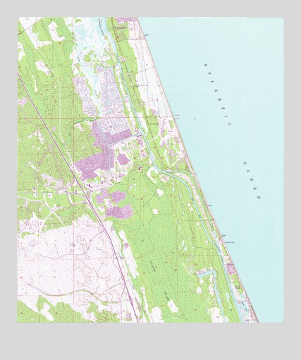
Beverly Beach, FL USGS Topographic Map
Click on map above to begin viewing in our Map Viewer.

This topographic map contains these locations and features:
Feature Name Type Latitude Longitude GNIS ID View Map
Beverly BeachPopulated PlaceN29.5147°W81.1445°295134View Map
Beverly Beach Trailer ParkPopulated PlaceN29.5273°W81.1520°2447741View Map
Big Mulberry BranchStreamN29.5858°W81.2103°278716View Map
Bon TerraPopulated PlaceN29.5816°W81.1881°295145View Map
City of Palm CoastCivilN29.5390°W81.2460°2404465View Map
Flagler Beach DivisionCivilN29.5476°W81.1579°1935766View Map
Flagler by the Sea Mobile Home ParkPopulated PlaceN29.5273°W81.1520°2448896View Map
Flagler County Fire Department Station 41 HammockBuildingN29.6072°W81.1984°2644412View Map
Flagler County Fire Rescue 21BuildingN29.5512°W81.2409°2644615View Map
Flagler County Fire Rescue 21BuildingN29.5517°W81.2378°2644406View Map
Flagler County Fire Rescue 22BuildingN29.5587°W81.2022°2644409View Map
Flagler County Fire Rescue Station 41BuildingN29.6072°W81.1985°2644353View Map
Flagler County Palm Coast Community CenterBuildingN29.5652°W81.1926°2451822View Map
Flagler County Sheriff's Office Beverly Beach SubstationBuildingN29.5202°W81.1467°2756008View Map
Flagler County Sheriff's Office Hammock SubstationBuildingN29.6167°W81.1956°2756133View Map
Flagler County Sheriff's Office Palm Coast SubstationBuildingN29.5521°W81.2238°2333130View Map
Fox CutChannelN29.5469°W81.1659°282764View Map
Graham SwampSwampN29.5213°W81.1802°283266View Map
Johnson Memorial ChapelChurchN29.5969°W81.1953°284882View Map
Lake Rayonier TwoLakeN29.5244°W81.2206°298568View Map
Little Mulberry BranchStreamN29.5858°W81.2103°285745View Map
Long CreekStreamN29.6211°W81.2131°285981View Map
Painters HillPopulated PlaceN29.5330°W81.1531°301597View Map
Palm CoastPopulated PlaceN29.5850°W81.2078°295049View Map
Palm Coast Fire Department Station 21BuildingN29.5513°W81.2408°2644616View Map
Palm Coast Fire Department Station 21BuildingN29.5517°W81.2378°2644407View Map
Palm Coast Fire Department Station 22BuildingN29.5587°W81.2021°2644408View Map
Palm Coast MarinaHarborN29.5769°W81.1933°2451829View Map
Palm Coast Post OfficePost OfficeN29.5522°W81.2345°2451828View Map
Royal Wood Golf and Country ClubLocaleN29.5642°W81.1996°2451823View Map
Sabal Palm Golf CourseLocaleN29.5305°W81.1667°2451824View Map
Saint Andrews Country ClubLocaleN29.6025°W81.1879°2451826View Map
Saint Augustine Shores Golf ClubLocaleN29.5388°W81.2451°2451827View Map
Saint Joe CanalCanalN29.5533°W81.2234°290206View Map
Silver LakeLakeN29.5064°W81.1432°291123View Map
Surfside Estates Mobile Home ParkPopulated PlaceN29.5223°W81.1501°2447742View Map
Town of Beverly BeachCivilN29.5163°W81.1474°2405260View Map
United Christian SchoolSchoolN29.5466°W81.2326°300619View Map

Note: Coordinates in the location and feature list above are referenced to NAD83 datum.


Copyright (C) 2008-2024 Ryan Niemi / Sunset Dynamics ... All Rights Reserved