TopoQuest Logo
Do you find TopoQuest useful?
Help keep TopoQuest running and adding new maps/features by donating!
Bitcoin:  19c7KJd3qBynnjoSw5npx9KScwjBe4ifkT
Litecoin:  LXs6TkuXGGXo1vDsWCkWVdjQX94eUKd6ui
Home View Maps Find Maps Find Places Resources & Links


Oakman, Georgia Topographic Map

USGS Map Title: Oakman, GA
USGS Map MRC: 34084E6
DRG (GeoTIFF) Download: o34084e6.tif


Neighboring USGS Topographic Map Quads:


  Calhoun NE, GA  
34084F7
 

  Ramhurst, GA  
34084F6
 

  Webb, GA  
34084F5
 

  Redbud, GA  
34084E7
 

  Oakman, GA  
34084E6
 

  Talking Rock, GA  
34084E5
 

  Sonoraville, GA  
34084D7
 

  Fairmount, GA  
34084D6
 

  Ludville, GA  
34084D5


Map MRC Location:

N35°
W85°
N35°
W84°
H8 H7 H6 H5 H4 H3 H2 H1
G8 G7 G6 G5 G4 G3 G2 G1
F8 F7 F6 F5 F4 F3 F2 F1
E8 E7 E6 E5 E4 E3 E2 E1
D8 D7 D6 D5 D4 D3 D2 D1
C8 C7 C6 C5 C4 C3 C2 C1
B8 B7 B6 B5 B4 B3 B2 B1
A8 A7 A6 A5 A4 A3 A2 A1
N34°
W85°
N34°
W84°

Oakman, GA USGS 1:24K Topographic Map Preview:
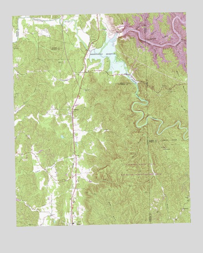
Oakman, GA USGS Topographic Map
Click on map above to begin viewing in our Map Viewer.

This topographic map contains these locations and features:
Feature Name Type Latitude Longitude GNIS ID View Map
Banks ChapelChurchN34.5965°W84.7149°354447View Map
Bethel ChurchChurchN34.5151°W84.6263°311205View Map
Camp BranchStreamN34.6051°W84.6333°312199View Map
CartersPopulated PlaceN34.6090°W84.6930°331332View Map
Carters DamDamN34.6131°W84.6708°312388View Map
Carters LakeReservoirN34.6158°W84.6359°327370View Map
Carters Reregulation DamDamN34.6034°W84.6933°337185View Map
ColimaPopulated PlaceN34.5431°W84.7072°326226View Map
Damsite OverlookLocaleN34.6162°W84.6710°356677View Map
Damsite Recreation AreaParkN34.6043°W84.6585°356678View Map
Duke CreekStreamN34.6237°W84.7413°313715View Map
Evans LakeReservoirN34.5526°W84.7155°340024View Map
Evans Lake DamDamN34.5534°W84.7166°340023View Map
Fair View ChurchChurchN34.5693°W84.7188°334447View Map
Fisher CreekStreamN34.6151°W84.6613°327823View Map
Goble BranchStreamN34.6226°W84.6316°327949View Map
Gordon County Fire / Rescue Department Station 10 RangerBuildingN34.5020°W84.7095°2604405View Map
Gordon County Fire and Rescue Department Station 9BuildingN34.5666°W84.7088°2604406View Map
Harris Branch Recreation AreaParkN34.6029°W84.6252°352939View Map
Harris CreekStreamN34.6081°W84.6291°315195View Map
Hopewell Baptist ChurchChurchN34.5801°W84.6988°356321View Map
Hopper LakeReservoirN34.5259°W84.6966°337158View Map
Lewis BranchStreamN34.6059°W84.6494°316778View Map
Liberty ChurchChurchN34.5065°W84.7249°356353View Map
Liberty School (historical)SchoolN34.5070°W84.7249°334473View Map
Long BranchStreamN34.5523°W84.6572°317335View Map
Macedonia ChurchChurchN34.5440°W84.6419°317575View Map
McDanielPopulated PlaceN34.5084°W84.6305°326393View Map
Mineral Springs BranchStreamN34.6209°W84.7038°328816View Map
New Hope ChurchChurchN34.5268°W84.7135°319442View Map
OakmanPopulated PlaceN34.5665°W84.7083°319868View Map
Oakman Post OfficePost OfficeN34.5662°W84.7085°352039View Map
Oakman School (historical)SchoolN34.5670°W84.7108°334484View Map
PetersburgPopulated PlaceN34.5868°W84.7155°326464View Map
Raccoon BranchStreamN34.5573°W84.6591°321265View Map
RangerPopulated PlaceN34.5012°W84.7097°332791View Map
Reregulation Dam Recreation AreaParkN34.6029°W84.6952°356679View Map
Reregulation PoolReservoirN34.6034°W84.6933°337186View Map
Reregulation ReservoirReservoirN34.5991°W84.6795°321525View Map
Rock Springs BranchStreamN34.6223°W84.7227°329476View Map
Sallacoa Creek Watershed Dam Number 77DamN34.5268°W84.6966°337157View Map
Sevenmile CreekStreamN34.5562°W84.6263°322719View Map
Shady Grove Baptist Church CemeteryCemeteryN34.5780°W84.6390°2681176View Map
Shady Grove ChurchChurchN34.5776°W84.6385°322769View Map
Sugar CreekStreamN34.6243°W84.7399°329883View Map
SwedenPopulated PlaceN34.5434°W84.6419°333173View Map
Talking Rock CreekStreamN34.6012°W84.6874°323889View Map
Talking Rock Wildlife Management AreaParkN34.5195°W84.6805°334515View Map
Tillman LakeReservoirN34.5149°W84.6444°336938View Map
Tillman Lake DamDamN34.5151°W84.6433°336937View Map
Town of RangerCivilN34.5013°W84.7111°2407174View Map
Wheeler (historical)Populated PlaceN34.5690°W84.7483°334520View Map
White Graves ChurchChurchN34.6062°W84.7497°356634View Map
Willbanks BranchStreamN34.6159°W84.7027°330287View Map
Wolf BranchStreamN34.5834°W84.6622°325476View Map
Woodridge Branch Recreation AreaParkN34.6223°W84.6402°356664View Map
Woodring BranchStreamN34.6073°W84.6494°330362View Map
Wurley CreekStreamN34.6226°W84.6316°330389View Map

Note: Coordinates in the location and feature list above are referenced to NAD83 datum.


Copyright (C) 2008-2024 Ryan Niemi / Sunset Dynamics ... All Rights Reserved