TopoQuest Logo
Do you find TopoQuest useful?
Help keep TopoQuest running and adding new maps/features by donating!
Bitcoin:  19c7KJd3qBynnjoSw5npx9KScwjBe4ifkT
Litecoin:  LXs6TkuXGGXo1vDsWCkWVdjQX94eUKd6ui
Home View Maps Find Maps Find Places Resources & Links


Orwell Lake, Minnesota Topographic Map

USGS Map Title: Orwell Lake, MN
USGS Map MRC: 46096B2
DRG (GeoTIFF) Download: o46096b2.tif


Neighboring USGS Topographic Map Quads:


  Foxhome, MN  
46096C3
 

  Carlisle, MN  
46096C2
 

  Fergus Falls, MN  
46096C1
 

  Campbell NE, MN  
46096B3
 

  Orwell Lake, MN  
46096B2
 

  Dayton Hollow Dam, MN  
46096B1
 

  Tintah, MN  
46096A3
 

  Stony Lake, MN  
46096A2
 

  Wendell, MN  
46096A1


Map MRC Location:

N47°
W97°
N47°
W96°
H8 H7 H6 H5 H4 H3 H2 H1
G8 G7 G6 G5 G4 G3 G2 G1
F8 F7 F6 F5 F4 F3 F2 F1
E8 E7 E6 E5 E4 E3 E2 E1
D8 D7 D6 D5 D4 D3 D2 D1
C8 C7 C6 C5 C4 C3 C2 C1
B8 B7 B6 B5 B4 B3 B2 B1
A8 A7 A6 A5 A4 A3 A2 A1
N46°
W97°
N46°
W96°

Orwell Lake, MN USGS 1:24K Topographic Map Preview:
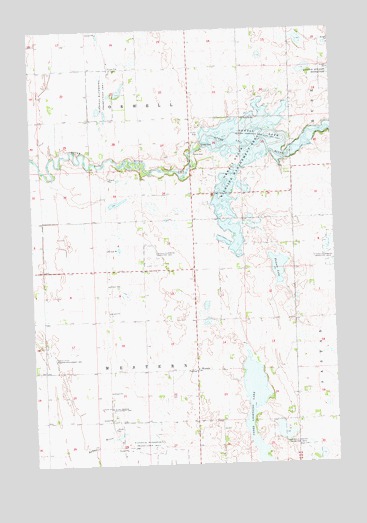
Orwell Lake, MN USGS Topographic Map
Click on map above to begin viewing in our Map Viewer.

This topographic map contains these locations and features:
Feature Name Type Latitude Longitude GNIS ID View Map
Doran State Wildlife Management AreaParkN46.1550°W96.2437°642893View Map
Emmanuel Lutheran Church CemeteryCemeteryN46.1525°W96.1839°2071818View Map
Faunce LakeLakeN46.1816°W96.1487°643579View Map
Orwell DamDamN46.2161°W96.1790°649006View Map
Orwell LakeReservoirN46.2182°W96.1765°649007View Map
Orwell Reservoir and DamDamN46.2166°W96.1803°1776786View Map
Orwell State Wildlife Management AreaParkN46.2133°W96.1614°649008View Map
Roberts (historical)Populated PlaceN46.1808°W96.1728°2119795View Map
Roberts Post Office (historical)Post OfficeN46.1819°W96.1653°2072983View Map
School Number 197 (historical)SchoolN46.2317°W96.1633°2119797View Map
School Number 243 (historical)SchoolN46.1306°W96.2464°2119809View Map
School Number 252 (historical)SchoolN46.2028°W96.1839°2119801View Map
School Number 261 (historical)SchoolN46.2247°W96.2261°2119796View Map
School Number 264 (historical)SchoolN46.1808°W96.2300°2119802View Map
School Number 49 (historical)SchoolN46.1342°W96.1828°2119808View Map
School Number 56 (historical)SchoolN46.1736°W96.1733°2119803View Map
Township of OrwellCivilN46.2382°W96.2043°665222View Map
Township of WesternCivilN46.1519°W96.2036°665962View Map
Upper Lightning LakeLakeN46.1361°W96.1612°653553View Map
WesternPopulated PlaceN46.1519°W96.1831°655006View Map
Western Post Office (historical)Post OfficeN46.1519°W96.1828°2072963View Map
Western Presbyterian CemeteryCemeteryN46.1528°W96.1819°2071819View Map
Western Presbyterian ChurchChurchN46.1528°W96.1822°2071035View Map

Note: Coordinates in the location and feature list above are referenced to NAD83 datum.


Copyright (C) 2008-2024 Ryan Niemi / Sunset Dynamics ... All Rights Reserved