TopoQuest Logo
Do you find TopoQuest useful?
Help keep TopoQuest running and adding new maps/features by donating!
Bitcoin:  19c7KJd3qBynnjoSw5npx9KScwjBe4ifkT
Litecoin:  LXs6TkuXGGXo1vDsWCkWVdjQX94eUKd6ui
Home View Maps Find Maps Find Places Resources & Links


Wendell, Minnesota Topographic Map

USGS Map Title: Wendell, MN
USGS Map MRC: 46096A1
DRG (GeoTIFF) Download: o46096a1.tif


Neighboring USGS Topographic Map Quads:


  Orwell Lake, MN  
46096B2
 

  Dayton Hollow Dam, MN  
46096B1
 

  Dalton, MN  
46095B8
 

  Stony Lake, MN  
46096A2
 

  Wendell, MN  
46096A1
 

  Fourmile Lake, MN  
46095A8
 

  Herman NW, MN  
45096H2
 

  Trisko Lake, MN  
45096H1
 

  Elbow Lake, MN  
45095H8


Map MRC Location:

N47°
W97°
N47°
W96°
H8 H7 H6 H5 H4 H3 H2 H1
G8 G7 G6 G5 G4 G3 G2 G1
F8 F7 F6 F5 F4 F3 F2 F1
E8 E7 E6 E5 E4 E3 E2 E1
D8 D7 D6 D5 D4 D3 D2 D1
C8 C7 C6 C5 C4 C3 C2 C1
B8 B7 B6 B5 B4 B3 B2 B1
A8 A7 A6 A5 A4 A3 A2 A1
N46°
W97°
N46°
W96°

Wendell, MN USGS 1:24K Topographic Map Preview:
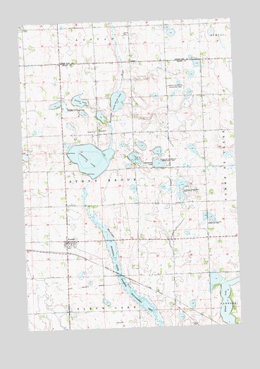
Wendell, MN USGS Topographic Map
Click on map above to begin viewing in our Map Viewer.

This topographic map contains these locations and features:
Feature Name Type Latitude Longitude GNIS ID View Map
Aastad Post Office (historical)Post OfficeN46.1078°W96.0583°2068470View Map
Bergerud State Wildlife Management AreaParkN46.0925°W96.1014°639962View Map
Brutlag Farms AirportAirportN46.0087°W96.1018°660469View Map
City of WendellCivilN46.0359°W96.1008°2397255View Map
Elbow LakeLakeN46.0074°W96.0068°643231View Map
Engralson LakeLakeN46.0666°W96.0452°643385View Map
Foss LakeLakeN46.0688°W96.0588°643830View Map
Grant County Waterfowl Production AreaParkN46.0757°W96.1112°2765316View Map
Lightning LakeLakeN46.0695°W96.0849°646638View Map
Mustinka State Wildlife Management AreaParkN46.0161°W96.0670°648409View Map
Pletan LakeLakeN46.0930°W96.0906°649588View Map
Rock Prairie CemeteryCemeteryN46.1078°W96.0569°2068472View Map
Rock Prairie Lutheran ChurchChurchN46.1078°W96.0583°2068473View Map
School Number 12 (historical)SchoolN46.0894°W96.1222°2119812View Map
School Number 29 East (historical)SchoolN46.0867°W96.0178°2119814View Map
School Number 29 West (historical)SchoolN46.0881°W96.0600°2119813View Map
School Number 30 (historical)SchoolN46.0431°W96.0594°2119815View Map
School Number 54 (historical)SchoolN46.0286°W96.0175°2119816View Map
Stony Brook LakeLakeN46.0928°W96.0683°652675View Map
Swift Airport (historical)AirportN46.0897°W96.0973°660467View Map
Township of Stony BrookCivilN46.0657°W96.0794°665719View Map
Trinity CemeteryCemeteryN46.0508°W96.1000°653293View Map
Trinity Lutheran ChurchChurchN46.0356°W96.1008°2068510View Map
WendellLocaleN46.0317°W96.0994°2068508View Map
WendellPopulated PlaceN46.0355°W96.1012°653909View Map
Wendell Fire DepartmentBuildingN46.0346°W96.1004°2666346View Map
Wendell Post Office (historical)Post OfficeN46.0356°W96.1008°2068509View Map

Note: Coordinates in the location and feature list above are referenced to NAD83 datum.


Copyright (C) 2008-2024 Ryan Niemi / Sunset Dynamics ... All Rights Reserved