TopoQuest Logo
Do you find TopoQuest useful?
Help keep TopoQuest running and adding new maps/features by donating!
Bitcoin:  19c7KJd3qBynnjoSw5npx9KScwjBe4ifkT
Litecoin:  LXs6TkuXGGXo1vDsWCkWVdjQX94eUKd6ui
Home View Maps Find Maps Find Places Resources & Links


Caulksville, Arkansas Topographic Map

USGS Map Title: Caulksville, AR
USGS Map MRC: 35093C7
DRG (GeoTIFF) Download: o35093c7.tif


Neighboring USGS Topographic Map Quads:


  Cecil, AR  
35093D8
 

  Ozark, AR  
35093D7
 

  Coal Hill, AR  
35093D6
 

  Branch, AR  
35093C8
 

  Caulksville, AR  
35093C7
 

  Paris, AR  
35093C6
 

  Booneville, AR  
35093B8
 

  Magazine, AR  
35093B7
 

  Blue Mountain, AR  
35093B6


Map MRC Location:

N36°
W94°
N36°
W93°
H8 H7 H6 H5 H4 H3 H2 H1
G8 G7 G6 G5 G4 G3 G2 G1
F8 F7 F6 F5 F4 F3 F2 F1
E8 E7 E6 E5 E4 E3 E2 E1
D8 D7 D6 D5 D4 D3 D2 D1
C8 C7 C6 C5 C4 C3 C2 C1
B8 B7 B6 B5 B4 B3 B2 B1
A8 A7 A6 A5 A4 A3 A2 A1
N35°
W94°
N35°
W93°

Caulksville, AR USGS 1:24K Topographic Map Preview:
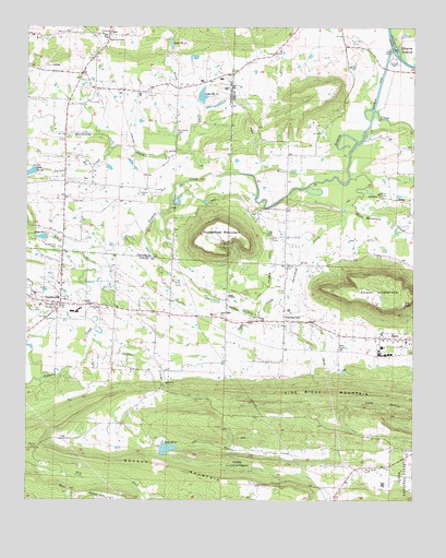
Caulksville, AR USGS Topographic Map
Click on map above to begin viewing in our Map Viewer.

This topographic map contains these locations and features:
Feature Name Type Latitude Longitude GNIS ID View Map
Agape Fellowship ChurchChurchN35.3012°W93.8558°79287View Map
Brushy MountainSummitN35.2526°W93.7866°70877View Map
Carbon CityPopulated PlaceN35.2976°W93.7919°71008View Map
Carpenter CemeteryCemeteryN35.3476°W93.8266°71015View Map
CaulksvillePopulated PlaceN35.3020°W93.8641°79127View Map
Caulksville Volunteer Fire DepartmentBuildingN35.3017°W93.8657°2116242View Map
Church of ChristChurchN35.3720°W93.8488°64715View Map
EtnaPopulated PlaceN35.3731°W93.8513°79289View Map
Gack CreekStreamN35.3084°W93.7899°71707View Map
Garner CreekStreamN35.3431°W93.8485°71731View Map
Horseshoe MountainSummitN35.3218°W93.8124°72088View Map
Hurricane CreekStreamN35.3365°W93.8066°72121View Map
Infant CemeteryCemeteryN35.2529°W93.8638°79286View Map
KCCL-AM (Paris)TowerN35.2973°W93.7794°85336View Map
KCCL-FM (Paris)TowerN35.3018°W93.7613°85416View Map
Lake Number OneReservoirN35.3196°W93.8703°79958View Map
Lake Number SeventeenReservoirN35.3707°W93.8287°82552View Map
Lake Number SixteenReservoirN35.3569°W93.8186°82555View Map
Lake Number TwentysixReservoirN35.3364°W93.8746°79954View Map
Lake Number TwoReservoirN35.2637°W93.8296°82577View Map
Little CreekStreamN35.2987°W93.8560°51242View Map
Little Flock ChurchChurchN35.2987°W93.8121°51269View Map
McVay CemeteryCemeteryN35.2643°W93.8716°72619View Map
McVay CemeteryCemeteryN35.3120°W93.7913°72620View Map
O'Kane ParkParkN35.3659°W93.7577°79288View Map
Oak Bend Etna Fire DepartmentBuildingN35.3638°W93.8565°2116884View Map
Paint Rock CemeteryCemeteryN35.2581°W93.7657°72980View Map
Roark CreekStreamN35.3115°W93.8508°73314View Map
Saint Anthony CemeteryCemeteryN35.3170°W93.8652°73451View Map
Shaver ChurchChurchN35.2809°W93.8308°73526View Map
Shaver CreekStreamN35.2929°W93.8555°73527View Map
Short Mountain CreekStreamN35.3351°W93.7705°78358View Map
Sixmile Creek Site 16 DamDamN35.3551°W93.8185°79949View Map
Sixmile Creek Site 17 DamDamN35.3701°W93.8252°79947View Map
Sixmile Creek Site 17 ReservoirReservoirN35.3701°W93.8252°79948View Map
Sixmile Creek Site 26 DamDamN35.3368°W93.8719°79953View Map
Sixmile Creek Site One DamDamN35.3201°W93.8685°79957View Map
Sixmile Creek Watershed Site Two DamDamN35.2651°W93.8319°80601View Map
Sixmile Creek Watershed Site Two ReservoirReservoirN35.2651°W93.8319°80602View Map
Stone CreekStreamN35.3420°W93.8230°73724View Map
Threemile CreekStreamN35.3284°W93.7702°73872View Map
Town of CaulksvilleCivilN35.3018°W93.8678°2406239View Map
Township of RosevilleCivilN35.3662°W93.7837°68802View Map
Township of Six MileCivilN35.2858°W93.8648°68805View Map
Township of WittichCivilN35.3489°W93.8594°66570View Map

Note: Coordinates in the location and feature list above are referenced to NAD83 datum.


Copyright (C) 2008-2025 Ryan Niemi / Sunset Dynamics ... All Rights Reserved