TopoQuest Logo
Do you find TopoQuest useful?
Help keep TopoQuest running and adding new maps/features by donating!
Bitcoin:  19c7KJd3qBynnjoSw5npx9KScwjBe4ifkT
Litecoin:  LXs6TkuXGGXo1vDsWCkWVdjQX94eUKd6ui
Home View Maps Find Maps Find Places Resources & Links


Paris, Arkansas Topographic Map

USGS Map Title: Paris, AR
USGS Map MRC: 35093C6
DRG (GeoTIFF) Download: o35093c6.tif


Neighboring USGS Topographic Map Quads:


  Ozark, AR  
35093D7
 

  Coal Hill, AR  
35093D6
 

  Hartman, AR  
35093D5
 

  Caulksville, AR  
35093C7
 

  Paris, AR  
35093C6
 

  Scranton, AR  
35093C5
 

  Magazine, AR  
35093B7
 

  Blue Mountain, AR  
35093B6
 

  Magazine Mountain NE, AR  
35093B5


Map MRC Location:

N36°
W94°
N36°
W93°
H8 H7 H6 H5 H4 H3 H2 H1
G8 G7 G6 G5 G4 G3 G2 G1
F8 F7 F6 F5 F4 F3 F2 F1
E8 E7 E6 E5 E4 E3 E2 E1
D8 D7 D6 D5 D4 D3 D2 D1
C8 C7 C6 C5 C4 C3 C2 C1
B8 B7 B6 B5 B4 B3 B2 B1
A8 A7 A6 A5 A4 A3 A2 A1
N35°
W94°
N35°
W93°

Paris, AR USGS 1:24K Topographic Map Preview:
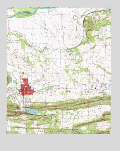
Paris, AR USGS Topographic Map
Click on map above to begin viewing in our Map Viewer.

This topographic map contains these locations and features:
Feature Name Type Latitude Longitude GNIS ID View Map
Air - Evacuation Lifeteam 22BuildingN35.2969°W93.6864°2119109View Map
Assembly of God ChurchChurchN35.3237°W93.6730°64181View Map
Assembly of God ChurchChurchN35.2687°W93.6605°64182View Map
Baxley CemeteryCemeteryN35.3145°W93.7230°70538View Map
Booker T Washington SchoolSchoolN35.3406°W93.7380°70764View Map
Church of ChristChurchN35.2579°W93.6344°74429View Map
Church of ChristChurchN35.2937°W93.7260°64175View Map
Church of ChristChurchN35.2579°W93.6346°64183View Map
City of ParisCivilN35.2897°W93.7229°2404472View Map
Corley Mountain Rural Fire Department Station 1BuildingN35.3403°W93.7412°2116304View Map
Cotton TownPopulated PlaceN35.3676°W93.6444°71238View Map
First Baptist ChurchChurchN35.2940°W93.7296°64167View Map
Geneva ParkParkN35.2929°W93.6330°71745View Map
Gray RockPopulated PlaceN35.3401°W93.7446°71823View Map
Gray Rock CemeteryCemeteryN35.3281°W93.7207°71824View Map
Greasy ValleyValleyN35.2679°W93.6871°71831View Map
Gum CreekStreamN35.2740°W93.6921°71856View Map
Hegwood CreekStreamN35.3320°W93.7124°71957View Map
Hixson CemeteryCemeteryN35.2970°W93.6905°72027View Map
Jackson ParkLocaleN35.2756°W93.7246°74427View Map
Johnson CemeteryCemeteryN35.2604°W93.6613°72203View Map
KalamazooPopulated PlaceN35.3681°W93.6946°72229View Map
Logan County CourthouseBuildingN35.2923°W93.7302°64179View Map
Logan County Emergency Medical ServiceBuildingN35.2926°W93.7271°2119110View Map
Logan County Sheriff's OfficeBuildingN35.2887°W93.7355°2118927View Map
Long HollowValleyN35.2743°W93.7335°72476View Map
McKendree ChurchChurchN35.3465°W93.6316°72602View Map
McLean BottomBendN35.3573°W93.6941°72612View Map
Moore CemeteryCemeteryN35.2684°W93.6441°72720View Map
Mount Magazine Road Office and Work CenterBuildingN35.2926°W93.7038°82591View Map
New Subiaco AcademySchoolN35.3001°W93.6330°72860View Map
North Logan Mercy HospitalHospitalN35.2893°W93.7250°64173View Map
Oak Grove ChurchChurchN35.3654°W93.6405°52911View Map
Oakwood CemeteryCemeteryN35.2912°W93.7157°52973View Map
Okane IslandIslandN35.3712°W93.7374°72926View Map
Oliver CemeteryCemeteryN35.3306°W93.6549°72944View Map
ParisPopulated PlaceN35.2920°W93.7299°72997View Map
Paris DamDamN35.2751°W93.7269°80599View Map
Paris Elementary SchoolSchoolN35.2914°W93.7145°2039157View Map
Paris Elmentary SchoolSchoolN35.2895°W93.7252°64174View Map
Paris Fire DepartmentBuildingN35.2930°W93.7280°2116932View Map
Paris Gas FieldOilfieldN35.3556°W93.7099°64180View Map
Paris High SchoolSchoolN35.2985°W93.7054°64176View Map
Paris Middle SchoolSchoolN35.2968°W93.7218°64177View Map
Paris Municipal AirportAirportN35.2969°W93.6846°83808View Map
Paris Police DepartmentBuildingN35.2915°W93.7136°2118863View Map
Paris Post OficeBuildingN35.2937°W93.7302°64168View Map
Paris ReservoirReservoirN35.2720°W93.7192°80600View Map
Pine HillSummitN35.3593°W93.6485°73090View Map
Pine Ridge MountainSummitN35.2768°W93.7471°73099View Map
Pleasant Grove ChurchChurchN35.3395°W93.7374°73122View Map
Raney CemeteryCemeteryN35.3334°W93.6733°73233View Map
Roseville Rural Volunteer Fire Department Station 2BuildingN35.3101°W93.7356°2117048View Map
Saint Benedict CemeteryCemeteryN35.2887°W93.6274°73452View Map
Saint Joseph SchoolSchoolN35.2912°W93.7327°73454View Map
Smith ClinicHospitalN35.2979°W93.7308°64178View Map
Spielerville (historical)Populated PlaceN35.3087°W93.6419°64184View Map
SubiacoPopulated PlaceN35.2929°W93.6346°79160View Map
Subiaco / Crossroads Fire Department Station 1BuildingN35.3290°W93.6316°2117182View Map
Subiaco / Crossroads Fire Department Station 2BuildingN35.2929°W93.6332°2117181View Map
Subiaco Dam LowerDamN35.2834°W93.6352°80593View Map
Subiaco Dam UpperDamN35.2818°W93.6435°80591View Map
Subiaco ReservoirReservoirN35.2810°W93.6446°80592View Map
Subiaco ReservoirReservoirN35.2825°W93.6371°80594View Map
Town of SubiacoCivilN35.2981°W93.6387°2406677View Map
Township of ClarkCivilN35.3278°W93.6360°68792View Map
Township of JohnsonCivilN35.2618°W93.6435°68796View Map
Township of Short MountainCivilN35.3083°W93.7283°68804View Map
Township of Titsworth (historical)CivilN35.3626°W93.6960°68807View Map
UnionPopulated PlaceN35.3206°W93.6674°73935View Map
Union ChurchChurchN35.3234°W93.6644°73938View Map

Note: Coordinates in the location and feature list above are referenced to NAD83 datum.


Copyright (C) 2008-2025 Ryan Niemi / Sunset Dynamics ... All Rights Reserved