TopoQuest Logo
Do you find TopoQuest useful?
Help keep TopoQuest running and adding new maps/features by donating!
Bitcoin:  19c7KJd3qBynnjoSw5npx9KScwjBe4ifkT
Litecoin:  LXs6TkuXGGXo1vDsWCkWVdjQX94eUKd6ui
Home View Maps Find Maps Find Places Resources & Links


Cedar Mountain, Utah Topographic Map

USGS Map Title: Cedar Mountain, UT
USGS Map MRC: 37113E1
DRG (GeoTIFF) Download: o37113e1.tif


Neighboring USGS Topographic Map Quads:


  Cedar City NW, UT  
37113F2
 

  Cedar City, UT  
37113F1
 

  Flanigan Arch, UT  
37112F8
 

  Kanarraville, UT  
37113E2
 

  Cedar Mountain, UT  
37113E1
 

  Webster Flat, UT  
37112E8
 

  Kolob Arch, UT  
37113D2
 

  Kolob Reservoir, UT  
37113D1
 

  Cogswell Point, UT  
37112D8


Map MRC Location:

N38°
W114°
N38°
W113°
H8 H7 H6 H5 H4 H3 H2 H1
G8 G7 G6 G5 G4 G3 G2 G1
F8 F7 F6 F5 F4 F3 F2 F1
E8 E7 E6 E5 E4 E3 E2 E1
D8 D7 D6 D5 D4 D3 D2 D1
C8 C7 C6 C5 C4 C3 C2 C1
B8 B7 B6 B5 B4 B3 B2 B1
A8 A7 A6 A5 A4 A3 A2 A1
N37°
W114°
N37°
W113°

Cedar Mountain, UT USGS 1:24K Topographic Map Preview:
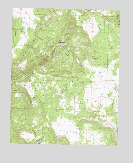
Cedar Mountain, UT USGS Topographic Map
Click on map above to begin viewing in our Map Viewer.

This topographic map contains these locations and features:
Feature Name Type Latitude Longitude GNIS ID View Map
Bean HillSummitN37.5072°W113.1144°1425334View Map
Blue ValleyValleyN37.5625°W113.1013°1425828View Map
Cabbage ValleyValleyN37.5872°W113.0688°1426251View Map
Cedar City Corp Storage DamDamN37.5350°W113.0908°1434637View Map
Cedar City Corp Storage ReservoirReservoirN37.5350°W113.0908°1434636View Map
Co-op FlatFlatN37.5747°W113.0169°1426740View Map
Co-op KnollSummitN37.5236°W113.0780°1426741View Map
Co-op SpringSpringN37.5181°W113.0693°1426743View Map
Cooks SpringSpringN37.6091°W113.0356°1426838View Map
Day SpringSpringN37.5305°W113.0509°1427236View Map
Death HollowValleyN37.5272°W113.0274°1427279View Map
Graff PointCliffN37.5533°W113.1091°1428296View Map
Hicks CreekStreamN37.6203°W113.1163°1428687View Map
Horse HollowValleyN37.5297°W113.0277°1428850View Map
Kanarra MountainSummitN37.5100°W113.0724°1429277View Map
Lee PointCliffN37.5230°W113.1024°1450417View Map
Long FlatFlatN37.5936°W113.0102°1429901View Map
Oak SpringSpringN37.5482°W113.1183°1430919View Map
Oak Spring FlatFlatN37.5441°W113.1166°1430928View Map
Pine SpringSpringN37.5382°W113.0649°1431269View Map
Pine Spring KnollSummitN37.5422°W113.0680°1431276View Map
Pryor KnollSummitN37.5794°W113.0302°1431489View Map
Reeves CreekStreamN37.5316°W113.1141°1431739View Map
Shirts CanyonValleyN37.6028°W113.1002°1432433View Map
Shiver CreekStreamN37.5228°W113.0302°1432413View Map
Square MountainSummitN37.6191°W113.0516°1432872View Map
Sugarloaf MountainSummitN37.5936°W113.0680°1433033View Map
The PyramidsSummitN37.5833°W113.0674°1437453View Map
Three KnollsSummitN37.5500°W113.0674°1437451View Map
Three Knolls SummitSummitN37.5064°W113.0644°1450530View Map
Tucker Coal MineMineN37.6122°W113.0008°1433691View Map
Woods HollowValleyN37.5322°W113.1244°1434469View Map

Note: Coordinates in the location and feature list above are referenced to NAD83 datum.


Copyright (C) 2008-2025 Ryan Niemi / Sunset Dynamics ... All Rights Reserved