TopoQuest Logo
Do you find TopoQuest useful?
Help keep TopoQuest running and adding new maps/features by donating!
Bitcoin:  19c7KJd3qBynnjoSw5npx9KScwjBe4ifkT
Litecoin:  LXs6TkuXGGXo1vDsWCkWVdjQX94eUKd6ui
Home View Maps Find Maps Find Places Resources & Links


Edenton, North Carolina Topographic Map

USGS Map Title: Edenton, NC
USGS Map MRC: 36076A5
DRG (GeoTIFF) Download: o36076a5.tif


Neighboring USGS Topographic Map Quads:


  Valhalla, NC  
36076B6
 

  Center Hill, NC  
36076B5
 

  Hertford, NC  
36076B4
 

  Edenhouse, NC  
36076A6
 

  Edenton, NC  
36076A5
 

  Yeopim River, NC  
36076A4
 

  Westover, NC  
35076H6
 

  Roper North, NC  
35076H5
 

  Leonards Point, NC  
35076H4


Map MRC Location:

N37°
W77°
N37°
W76°
H8 H7 H6 H5 H4 H3 H2 H1
G8 G7 G6 G5 G4 G3 G2 G1
F8 F7 F6 F5 F4 F3 F2 F1
E8 E7 E6 E5 E4 E3 E2 E1
D8 D7 D6 D5 D4 D3 D2 D1
C8 C7 C6 C5 C4 C3 C2 C1
B8 B7 B6 B5 B4 B3 B2 B1
A8 A7 A6 A5 A4 A3 A2 A1
N36°
W77°
N36°
W76°

Edenton, NC USGS 1:24K Topographic Map Preview:
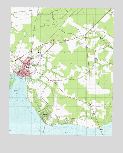
Edenton, NC USGS Topographic Map
Click on map above to begin viewing in our Map Viewer.

This topographic map contains these locations and features:
Feature Name Type Latitude Longitude GNIS ID View Map
Albemarle Baptist ChurchChurchN36.0310°W76.5777°2506074View Map
Allison HouseBuildingN36.0585°W76.6097°1006818View Map
BarberPopulated PlaceN36.1227°W76.5924°1018957View Map
Barker HouseBuildingN36.0565°W76.6097°1006813View Map
Beaver Hill CemeteryCemeteryN36.0668°W76.6159°1004120View Map
Bethel (historical)Populated PlaceN36.1065°W76.5258°1019107View Map
Beverly HallBuildingN36.0585°W76.6102°1006819View Map
Blair HouseBuildingN36.0613°W76.6080°1006808View Map
Booth HouseBuildingN36.0621°W76.6105°1006807View Map
Canaan TempleChurchN36.0657°W76.5263°1004126View Map
Cape ColonyPopulated PlaceN36.0196°W76.5816°1004112View Map
Charlton HouseBuildingN36.0599°W76.6130°1006805View Map
Cherry PointCapeN36.0365°W76.6038°983088View Map
Chowan County Court HouseBuildingN36.0579°W76.6080°1006826View Map
Chowan County Court HouseBuildingN36.0579°W76.6077°1004116View Map
Chowan County Emergency Medical Services Unit 1BuildingN36.0686°W76.6109°2720380View Map
Chowan County Office BuildingBuildingN36.0579°W76.6080°1006828View Map
Chowan County Sheriff's OfficeBuildingN36.0657°W76.6115°2130932View Map
Coffield HouseBuildingN36.0577°W76.6058°1006811View Map
Courthouse GreenLocaleN36.0579°W76.6080°1006825View Map
Cupola HouseBuildingN36.0568°W76.6099°1006814View Map
D F Walker High SchoolSchoolN36.0688°W76.6011°1025930View Map
Dixon-Powell HouseBuildingN36.0590°W76.6124°1006822View Map
EdentonPopulated PlaceN36.0579°W76.6077°1025302View Map
Edenton Baptist ChurchChurchN36.0604°W76.6121°2505876View Map
Edenton BayBayN36.0607°W76.6091°1008263View Map
Edenton Church of ChristChurchN36.0766°W76.6175°2505877View Map
Edenton Fire DepartmentBuildingN36.0683°W76.6055°2638158View Map
Edenton Marine Corps Air Station (historical)MilitaryN36.0250°W76.5642°2091948View Map
Edenton Municipal BuildingBuildingN36.0565°W76.6097°1007094View Map
Edenton Police DepartmentBuildingN36.0653°W76.6118°2131005View Map
Edenton Post OfficePost OfficeN36.0610°W76.6078°1004117View Map
Edenton Teapot SiteLocaleN36.0574°W76.6086°1006812View Map
Edenton Village Shopping CenterLocaleN36.0779°W76.5913°1007263View Map
Edenton Water TowerTowerN36.0607°W76.6024°984629View Map
Gale Street Baptist ChurchChurchN36.0623°W76.6086°2506126View Map
Hewes HouseBuildingN36.0579°W76.6099°1006817View Map
Holmes High SchoolSchoolN36.0668°W76.6047°1002681View Map
Holy Temple ChurchChurchN36.0727°W76.5972°1004123View Map
Homestead HouseBuildingN36.0568°W76.6099°1006816View Map
Horniblow PointCapeN36.0096°W76.5727°1025397View Map
Iredell HouseBuildingN36.0613°W76.6080°1006809View Map
Johnston CemeteryCemeteryN36.0529°W76.6019°1004115View Map
Kingdom Hall of Jehovahs WitnessesChurchN36.0840°W76.5777°2506105View Map
Leary HouseBuildingN36.0568°W76.6097°1006815View Map
Little CreekStreamN36.0557°W76.6077°988592View Map
Littlejohn HouseBuildingN36.0593°W76.6136°1006824View Map
Mackey Ferry (historical)LocaleN36.0560°W76.6094°1002682View Map
Mill CreekStreamN36.0857°W76.5005°989930View Map
Northeastern Regional AirportAirportN36.0200°W76.5661°998016View Map
Northside Shopping CenterLocaleN36.0752°W76.5983°1007264View Map
Open Door Baptist ChurchChurchN36.0944°W76.5342°2506208View Map
Paine HouseBuildingN36.0613°W76.6113°1006806View Map
Pembroke CreekStreamN36.0563°W76.6063°1027445View Map
Pembroke HallBuildingN36.0582°W76.6113°1006821View Map
Pleasant Grove ChurchChurchN36.0638°W76.6047°1004119View Map
Privott HouseBuildingN36.0577°W76.6058°1006810View Map
Providence ChurchChurchN36.0621°W76.6127°1004118View Map
Saint Anns Catholic ChurchChurchN36.0613°W76.6080°1002690View Map
Saint JohnsPopulated PlaceN36.0307°W76.5266°993925View Map
Saint Johns ChurchChurchN36.0313°W76.5094°1004113View Map
Saint Luke ChurchChurchN36.0760°W76.6013°1004121View Map
Saint Mark Mobile Home ParkPopulated PlaceN36.0670°W76.6202°2505573View Map
Saint Pauls Episcopal ChurchChurchN36.0613°W76.6088°1002691View Map
Sandy PointCapeN36.0069°W76.5139°982395View Map
Swain SchoolSchoolN36.0599°W76.6063°1002680View Map
Town of EdentonCivilN36.0581°W76.6010°2406422View Map
Township 4-YeopimCivilN36.0330°W76.5066°1026553View Map
Union Grove ChurchChurchN36.0688°W76.5927°1004124View Map
Vidant Chowan HospitalHospitalN36.0700°W76.6114°1006827View Map
Vine Oak CemeteryCemeteryN36.0668°W76.6101°1004122View Map
WBXB-FM (Edenton)TowerN36.1199°W76.5911°1025084View Map
WCDJ-AM (Edenton)TowerN36.0796°W76.5997°1025855View Map
Wessington HouseBuildingN36.0588°W76.6111°1006820View Map
West Custom HouseBuildingN36.0593°W76.6136°1006823View Map
WZBO-FM (Edenton)TowerN36.0835°W76.5997°1018329View Map
YeopimLocaleN36.0760°W76.5222°1004127View Map

Note: Coordinates in the location and feature list above are referenced to NAD83 datum.


Copyright (C) 2008-2025 Ryan Niemi / Sunset Dynamics ... All Rights Reserved