TopoQuest Logo
Do you find TopoQuest useful?
Help keep TopoQuest running and adding new maps/features by donating!
Bitcoin:  19c7KJd3qBynnjoSw5npx9KScwjBe4ifkT
Litecoin:  LXs6TkuXGGXo1vDsWCkWVdjQX94eUKd6ui
Home View Maps Find Maps Find Places Resources & Links


Center Peak, New Mexico Topographic Map

USGS Map Title: Center Peak, NM
USGS Map MRC: 31108E6
DRG (GeoTIFF) Download: o31108e6.tif


Neighboring USGS Topographic Map Quads:


  Animas Peak NE, NM  
31108F7
 

  Gillespie Mountain, NM  
31108F6
 

  Walnut Wells NE, NM  
31108F5
 

  Animas Peak, NM  
31108E7
 

  Center Peak, NM  
31108E6
 

  Horse Mountain, NM  
31108E5
 

  Fitzpatricks, NM  
31108D7
 

  San Luis Pass, NM  
31108D6
 

  Hilo Peak, NM  
31108D5


Map MRC Location:

N32°
W109°
N32°
W108°
H8 H7 H6 H5 H4 H3 H2 H1
G8 G7 G6 G5 G4 G3 G2 G1
F8 F7 F6 F5 F4 F3 F2 F1
E8 E7 E6 E5 E4 E3 E2 E1
D8 D7 D6 D5 D4 D3 D2 D1
C8 C7 C6 C5 C4 C3 C2 C1
B8 B7 B6 B5 B4 B3 B2 B1
A8 A7 A6 A5 A4 A3 A2 A1
N31°
W109°
N31°
W108°

Center Peak, NM USGS 1:24K Topographic Map Preview:
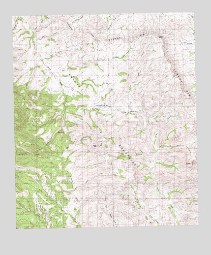
Center Peak, NM USGS Topographic Map
Click on map above to begin viewing in our Map Viewer.

This topographic map contains these locations and features:
Feature Name Type Latitude Longitude GNIS ID View Map
7K PeakSummitN31.5362°W108.6295°900735View Map
Bear CanyonValleyN31.5379°W108.6573°886126View Map
Bennett SpringSpringN31.6159°W108.6289°886219View Map
Boulder TankReservoirN31.5932°W108.7392°900829View Map
Box CanyonValleyN31.6101°W108.7359°896733View Map
Brown CanyonValleyN31.5232°W108.7106°900831View Map
Center PeakSummitN31.5465°W108.6864°899567View Map
Cowboy RimCliffN31.6101°W108.6587°900857View Map
Cowboy SpringSpringN31.6082°W108.6362°887988View Map
Cowboy Spring Wilderness Study AreaParkN31.6082°W108.6362°935831View Map
Cowboy Springs (historical)LocaleN31.6082°W108.6362°924496View Map
Elephant ButteSummitN31.6112°W108.6495°900830View Map
Elephant Butte CanyonValleyN31.5668°W108.6700°888838View Map
Frankie TankReservoirN31.5283°W108.7156°901161View Map
Gibson TankReservoirN31.5563°W108.7167°901151View Map
Henrys CabinLocaleN31.6240°W108.7028°889909View Map
Indian CreekStreamN31.5057°W108.7109°915937View Map
Lawhorn CanyonValleyN31.5673°W108.6700°890990View Map
Lawhorn TankReservoirN31.5672°W108.6709°901173View Map
Lawhorns RanchLocaleN31.5665°W108.6700°890991View Map
Lower Walnut TankReservoirN31.5711°W108.6878°901174View Map
North 7K CanyonValleyN31.5601°W108.6575°900856View Map
O K Bar RanchLocaleN31.5920°W108.7250°892776View Map
Park CanyonValleyN31.5915°W108.7231°893078View Map
Park TankReservoirN31.5839°W108.6894°900734View Map
Post CanyonValleyN31.5990°W108.7295°900858View Map
Rock Guard TankReservoirN31.5513°W108.7053°900940View Map
South 7K CanyonValleyN31.5432°W108.6545°900855View Map
Tahoe TankReservoirN31.5465°W108.7163°900793View Map
The ParkFlatN31.6001°W108.6756°898452View Map
Tullous TankReservoirN31.5082°W108.7150°895893View Map
Tullous Upper RanchLocaleN31.5029°W108.7328°895894View Map
Walnut TankReservoirN31.5696°W108.6974°900792View Map
Wolf CanyonValleyN31.6162°W108.7367°915938View Map

Note: Coordinates in the location and feature list above are referenced to NAD83 datum.


Copyright (C) 2008-2025 Ryan Niemi / Sunset Dynamics ... All Rights Reserved