TopoQuest Logo
Do you find TopoQuest useful?
Help keep TopoQuest running and adding new maps/features by donating!
Bitcoin:  19c7KJd3qBynnjoSw5npx9KScwjBe4ifkT
Litecoin:  LXs6TkuXGGXo1vDsWCkWVdjQX94eUKd6ui
Home View Maps Find Maps Find Places Resources & Links


Chadbourn, North Carolina Topographic Map

USGS Map Title: Chadbourn, NC
USGS Map MRC: 34078C7
DRG (GeoTIFF) Download: o34078c7.tif


Neighboring USGS Topographic Map Quads:


  Evergreen, NC  
34078D8
 

  Chadbourn NE, NC  
34078D7
 

  Clarkton, NC  
34078D6
 

  Cerro Gordo, NC  
34078C8
 

  Chadbourn, NC  
34078C7
 

  Whiteville, NC  
34078C6
 

  Tabor City West, NC  
34078B8
 

  Tabor City East, NC  
34078B7
 

  Nakina, NC  
34078B6


Map MRC Location:

N35°
W79°
N35°
W78°
H8 H7 H6 H5 H4 H3 H2 H1
G8 G7 G6 G5 G4 G3 G2 G1
F8 F7 F6 F5 F4 F3 F2 F1
E8 E7 E6 E5 E4 E3 E2 E1
D8 D7 D6 D5 D4 D3 D2 D1
C8 C7 C6 C5 C4 C3 C2 C1
B8 B7 B6 B5 B4 B3 B2 B1
A8 A7 A6 A5 A4 A3 A2 A1
N34°
W79°
N34°
W78°

Chadbourn, NC USGS 1:24K Topographic Map Preview:
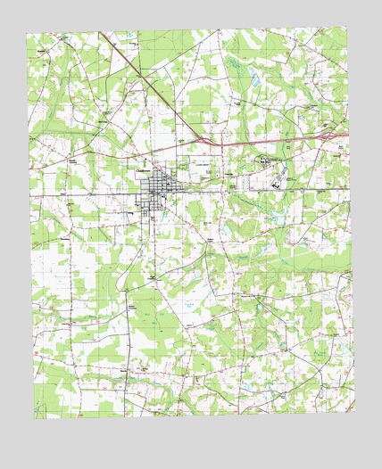
Chadbourn, NC USGS Topographic Map
Click on map above to begin viewing in our Map Viewer.

This topographic map contains these locations and features:
Feature Name Type Latitude Longitude GNIS ID View Map
Belle View CemeteryCemeteryN34.3124°W78.8084°980953View Map
Benson Mill PondReservoirN34.3137°W78.7777°1025138View Map
Big BranchStreamN34.2554°W78.8203°981355View Map
Big Pond BayFlatN34.2718°W78.7645°1025152View Map
Bird CagePopulated PlaceN34.3460°W78.8439°981498View Map
Boege BayFlatN34.3313°W78.7897°1025173View Map
BraswellPopulated PlaceN34.3688°W78.8675°1019283View Map
BroadwayPopulated PlaceN34.3060°W78.8597°1019311View Map
Cedar BranchStreamN34.2974°W78.7781°1025228View Map
Cedar Hill ChurchChurchN34.3221°W78.7595°982866View Map
ChadbournPopulated PlaceN34.3221°W78.8270°982979View Map
Chadbourn Baptist ChurchChurchN34.3268°W78.8225°2505931View Map
Chadbourn CemeteryCemeteryN34.3263°W78.8092°982980View Map
Chadbourn Church of GodChurchN34.3334°W78.8292°2505932View Map
Chadbourn Community LibraryBuildingN34.3249°W78.8253°2506328View Map
Chadbourn Elementary SchoolSchoolN34.3253°W78.8211°1006503View Map
Chadbourn Junior High SchoolSchoolN34.3163°W78.8350°1006502View Map
Chadbourn Pentecostal Holiness ChurchChurchN34.3270°W78.8170°2505933View Map
Chadbourn Police DepartmentBuildingN34.3279°W78.8261°2131059View Map
Chadbourn Post OfficePost OfficeN34.3277°W78.8269°2505346View Map
Chadbourn Presbyterian ChurchChurchN34.3233°W78.8173°2505934View Map
Chadbourn United Methodist ChurchChurchN34.3250°W78.8228°2505935View Map
Chadbourne Wastewater Treatment PlantLocaleN34.3258°W78.7978°2505999View Map
China Grove ChurchChurchN34.2804°W78.8597°983141View Map
Corinth ChurchChurchN34.3732°W78.8614°983552View Map
Deep BranchStreamN34.2977°W78.7517°1025280View Map
Fipps CrossingPopulated PlaceN34.2943°W78.8267°1006202View Map
First Baptist ChurchChurchN34.3177°W78.8311°2505818View Map
Fivemile BayFlatN34.2849°W78.8131°1025315View Map
Fivemile BranchStreamN34.2988°W78.7767°985137View Map
Fox Pond BayFlatN34.2791°W78.8070°1025325View Map
GristPopulated PlaceN34.3224°W78.8609°1026260View Map
Hell Cat BayFlatN34.2804°W78.8272°1025379View Map
Hog BranchStreamN34.2866°W78.7856°986875View Map
Horsepen BranchStreamN34.3229°W78.8145°1025402View Map
Hughes Airport (historical)AirportN34.3296°W78.8086°1025856View Map
Jerusalem ChurchChurchN34.3707°W78.8314°1026255View Map
Juniper BayFlatN34.3391°W78.7750°1025440View Map
Juniper CreekStreamN34.3163°W78.7759°1025442View Map
Klondyke - Chadbourn Fire Department and Rescue SquadBuildingN34.3241°W78.8248°2638392View Map
Living Word ChurchChurchN34.3266°W78.8132°2505504View Map
Lynn HillSummitN34.3429°W78.7572°1021316View Map
Mire BranchStreamN34.2963°W78.7670°990068View Map
Mount Zion ChurchChurchN34.2652°W78.8334°990622View Map
Mount Zion ChurchChurchN34.3193°W78.8603°1026259View Map
Nobles CrossingPopulated PlaceN34.2849°W78.8381°1021654View Map
Our Lords ChapelChurchN34.3516°W78.7917°1026254View Map
PeacocksPopulated PlaceN34.3268°W78.7995°1025603View Map
Pine Log BaySwampN34.3624°W78.7945°992267View Map
Pleasant Hill ChurchChurchN34.2882°W78.7884°1025619View Map
Potters CurvePopulated PlaceN34.3054°W78.8064°1006337View Map
Powells CrossingPopulated PlaceN34.3341°W78.8603°1022069View Map
Pridgen ChurchChurchN34.3491°W78.7642°992815View Map
Ruddy BranchStreamN34.2774°W78.7845°993797View Map
Saint John ChurchChurchN34.3393°W78.8167°1026253View Map
Sellers BranchStreamN34.2538°W78.7820°994492View Map
Southeast Regional ParkLocaleN34.3309°W78.7687°2505184View Map
Southeastern Community CollegeSchoolN34.3324°W78.7836°1026242View Map
Spring BranchStreamN34.2943°W78.7500°1025725View Map
Spring Hill ChurchChurchN34.3338°W78.7534°995343View Map
Town of ChadbournCivilN34.3247°W78.8250°2406253View Map
Township of ChadbournCivilN34.3163°W78.8320°1026575View Map
United Holy Temple ChurchChurchN34.3239°W78.8229°2506296View Map
WardsPopulated PlaceN34.2657°W78.8386°1027475View Map
WVOE-AM (Chadbourn)TowerN34.3516°W78.8436°1018358View Map
Zion Wall Free Will Baptist ChurchChurchN34.3186°W78.8328°2506324View Map

Note: Coordinates in the location and feature list above are referenced to NAD83 datum.


Copyright (C) 2008-2025 Ryan Niemi / Sunset Dynamics ... All Rights Reserved