TopoQuest Logo
Do you find TopoQuest useful?
Help keep TopoQuest running and adding new maps/features by donating!
Bitcoin:  19c7KJd3qBynnjoSw5npx9KScwjBe4ifkT
Litecoin:  LXs6TkuXGGXo1vDsWCkWVdjQX94eUKd6ui
Home View Maps Find Maps Find Places Resources & Links


Whiteville, North Carolina Topographic Map

USGS Map Title: Whiteville, NC
USGS Map MRC: 34078C6
DRG (GeoTIFF) Download: o34078c6.tif


Neighboring USGS Topographic Map Quads:


  Chadbourn NE, NC  
34078D7
 

  Clarkton, NC  
34078D6
 

  Emerson, NC  
34078D5
 

  Chadbourn, NC  
34078C7
 

  Whiteville, NC  
34078C6
 

  Lake Waccamaw West, NC  
34078C5
 

  Tabor City East, NC  
34078B7
 

  Nakina, NC  
34078B6
 

  Old Dock, NC  
34078B5


Map MRC Location:

N35°
W79°
N35°
W78°
H8 H7 H6 H5 H4 H3 H2 H1
G8 G7 G6 G5 G4 G3 G2 G1
F8 F7 F6 F5 F4 F3 F2 F1
E8 E7 E6 E5 E4 E3 E2 E1
D8 D7 D6 D5 D4 D3 D2 D1
C8 C7 C6 C5 C4 C3 C2 C1
B8 B7 B6 B5 B4 B3 B2 B1
A8 A7 A6 A5 A4 A3 A2 A1
N34°
W79°
N34°
W78°

Whiteville, NC USGS 1:24K Topographic Map Preview:
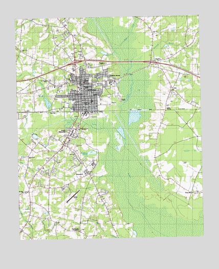
Whiteville, NC USGS Topographic Map
Click on map above to begin viewing in our Map Viewer.

This topographic map contains these locations and features:
Feature Name Type Latitude Longitude GNIS ID View Map
Baldwin WoodsPopulated PlaceN34.3427°W78.6892°1018937View Map
Barb Crest Trailer ParkPopulated PlaceN34.3433°W78.7123°2505411View Map
BrunswickPopulated PlaceN34.2868°W78.7011°982045View Map
Brunswick Post OfficePost OfficeN34.2879°W78.7021°2505338View Map
Brunswick Volunteer Fire DepartmentBuildingN34.2889°W78.7029°2638749View Map
Camp BranchStreamN34.2860°W78.6811°1025217View Map
Cape Fear Fire ProtectionBuildingN34.3645°W78.7167°2638654View Map
Cherry Grove CemeteryCemeteryN34.3027°W78.7103°983079View Map
Cherry Grove ChurchChurchN34.2974°W78.7100°983081View Map
City of WhitevilleCivilN34.3306°W78.7014°2405738View Map
Columbus Christian AcademySchoolN34.3309°W78.7039°1003646View Map
Columbus Correctional InstitutionBuildingN34.2785°W78.7199°2505308View Map
Columbus Country Memorial ParkCemeteryN34.3121°W78.7078°1025259View Map
Columbus CountyCivilN34.2656°W78.6550°1026339View Map
Columbus County CourthouseBuildingN34.3388°W78.7036°1003645View Map
Columbus County Emergency Medical ServicesBuildingN34.3220°W78.7055°2720413View Map
Columbus County Law EnforcementBuildingN34.3369°W78.7186°2131007View Map
Columbus County Municipal AirportAirportN34.2744°W78.7152°997848View Map
Columbus County Public LibraryBuildingN34.3340°W78.7085°2506331View Map
Columbus County Sheriff's AdministrationBuildingN34.3369°W78.7186°2130942View Map
Columbus County Sheriff's OfficeBuildingN34.3369°W78.7186°2130952View Map
Columbus Regional Healthcare System HospitalHospitalN34.3377°W78.6942°1024452View Map
Edgewood SchoolSchoolN34.3316°W78.6970°1003643View Map
Fairfax HeightsPopulated PlaceN34.2918°W78.7331°1005164View Map
Faison CemeteryCemeteryN34.2921°W78.6375°984937View Map
Flynn CemeteryCemeteryN34.3416°W78.6347°985254View Map
Gray BranchStreamN34.3443°W78.7381°985983View Map
HallsPopulated PlaceN34.3399°W78.6436°1003651View Map
Harrelsonville CrossroadsPopulated PlaceN34.2546°W78.7092°986437View Map
Honey HillPopulated PlaceN34.2754°W78.6331°1006243View Map
Lewis Smith Shopping CenterLocaleN34.3168°W78.7081°1007266View Map
Liberty Commons Nursing and Rehabilitation of ColumbusBuildingN34.3461°W78.7008°2506021View Map
McKenzie WoodsPopulated PlaceN34.3388°W78.6997°1005162View Map
Mill Branch ChurchChurchN34.2513°W78.6858°989892View Map
Mollie BranchStreamN34.3177°W78.7109°1025553View Map
New Hope ChurchChurchN34.2771°W78.7470°990988View Map
New Hope SchoolSchoolN34.2752°W78.7428°991040View Map
North Carolina State Highway Patrol Troop B District 5BuildingN34.3363°W78.7227°2131060View Map
Peace ChurchChurchN34.3079°W78.7272°1003641View Map
Pine LogPopulated PlaceN34.3238°W78.7256°992266View Map
Pine Log BranchStreamN34.3182°W78.7247°1025609View Map
Pine Log SwampSwampN34.3282°W78.7289°992270View Map
Puncheon BranchStreamN34.3502°W78.6714°1025630View Map
Richardson MillpondReservoirN34.2988°W78.6996°993312View Map
RunnymeadePopulated PlaceN34.3404°W78.6983°1005161View Map
Saint Paul ChurchChurchN34.3538°W78.7109°1003648View Map
Shoreland Health Care and Retirement CenterBuildingN34.3489°W78.7051°2505762View Map
Smith CemeteryCemeteryN34.3257°W78.6472°994938View Map
Smith CrossingPopulated PlaceN34.3221°W78.6486°994974View Map
Soules SwampStreamN34.3057°W78.6867°1025715View Map
South WhitevillePopulated PlaceN34.3054°W78.7153°995223View Map
Spring Branch ChurchChurchN34.2968°W78.7422°995326View Map
State Prison Camp Number 602LocaleN34.2793°W78.7189°1023693View Map
Sunset TerracePopulated PlaceN34.3391°W78.7256°1005163View Map
Town of BrunswickCivilN34.2880°W78.7012°2405337View Map
Township of WhitevilleCivilN34.3369°W78.7393°1026584View Map
Union Valley ChurchChurchN34.3574°W78.7450°996518View Map
Waccamaw AcademySchoolN34.3491°W78.6895°1003644View Map
Ward CemeteryCemeteryN34.2760°W78.6297°996770View Map
Welch CreekStreamN34.3571°W78.6811°1025781View Map
WENC-AM (Whiteville)TowerN34.3085°W78.7164°1018355View Map
West Whiteville ChurchChurchN34.3399°W78.7275°1003650View Map
White Marsh ChurchChurchN34.3502°W78.6533°997145View Map
WhitevillePopulated PlaceN34.3388°W78.7031°1025798View Map
Whiteville CemeteryCemeteryN34.3532°W78.7053°997259View Map
Whiteville City HallBuildingN34.3266°W78.7028°1003642View Map
Whiteville Fire DepartmentBuildingN34.3261°W78.7019°2638743View Map
Whiteville High SchoolSchoolN34.3347°W78.7061°1003647View Map
Whiteville PlazaLocaleN34.3060°W78.7153°1007267View Map
Whiteville Police DepartmentBuildingN34.3266°W78.7021°2131017View Map
Whiteville Post OfficePost OfficeN34.3285°W78.7050°1024962View Map
Whiteville Rescue SquadBuildingN34.3487°W78.7026°2720553View Map
Whiteville SchoolSchoolN34.3396°W78.7131°1003649View Map
Whiteville Whitemarsh Wastewater TreatmentLocaleN34.3288°W78.6788°2506337View Map
WQTR-FM (Whiteville)TowerN34.3085°W78.7164°1018614View Map
WTXY-AM (Whiteville)TowerN34.3232°W78.7128°1018356View Map

Note: Coordinates in the location and feature list above are referenced to NAD83 datum.


Copyright (C) 2008-2024 Ryan Niemi / Sunset Dynamics ... All Rights Reserved