TopoQuest Logo
Do you find TopoQuest useful?
Help keep TopoQuest running and adding new maps/features by donating!
Bitcoin:  19c7KJd3qBynnjoSw5npx9KScwjBe4ifkT
Litecoin:  LXs6TkuXGGXo1vDsWCkWVdjQX94eUKd6ui
Home View Maps Find Maps Find Places Resources & Links


Chalk Mountain, Texas Topographic Map

USGS Map Title: Chalk Mountain, TX
USGS Map MRC: 32097B8
DRG (GeoTIFF) Download: o32097b8.tif


Neighboring USGS Topographic Map Quads:


  Bluff Dale, TX  
32098C1
 

  Paluxy, TX  
32097C8
 

  Hill City, TX  
32097C7
 

  Johnsville, TX  
32098B1
 

  Chalk Mountain, TX  
32097B8
 

  Glen Rose West, TX  
32097B7
 

  Clairette, TX  
32098A1
 

  Camp Branch, TX  
32097A8
 

  Walnut Springs West, TX  
32097A7


Map MRC Location:

N33°
W98°
N33°
W97°
H8 H7 H6 H5 H4 H3 H2 H1
G8 G7 G6 G5 G4 G3 G2 G1
F8 F7 F6 F5 F4 F3 F2 F1
E8 E7 E6 E5 E4 E3 E2 E1
D8 D7 D6 D5 D4 D3 D2 D1
C8 C7 C6 C5 C4 C3 C2 C1
B8 B7 B6 B5 B4 B3 B2 B1
A8 A7 A6 A5 A4 A3 A2 A1
N32°
W98°
N32°
W97°

Chalk Mountain, TX USGS 1:24K Topographic Map Preview:
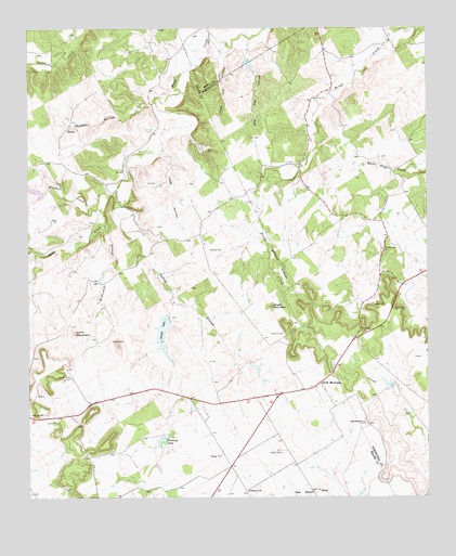
Chalk Mountain, TX USGS Topographic Map
Click on map above to begin viewing in our Map Viewer.

This topographic map contains these locations and features:
Feature Name Type Latitude Longitude GNIS ID View Map
Big Kid HollowValleyN32.2471°W97.9302°1330615View Map
Brock LakeReservoirN32.2230°W97.9620°1864008View Map
Brock Lake Number 1 DamDamN32.2235°W97.9620°1864007View Map
Brock Lake Number 2ReservoirN32.2335°W97.9570°1864012View Map
Brock Lake Number 2 DamLakeN32.2328°W97.9576°1864011View Map
Buffalo HollowValleyN32.2306°W97.9604°1331574View Map
Chalk MountainPopulated PlaceN32.1543°W97.9109°1332619View Map
Chalk MountainSummitN32.1760°W97.9242°1332620View Map
Chalk Mountain ChurchChurchN32.1446°W97.8953°1332622View Map
Chimney LakeReservoirN32.1405°W97.9584°1332760View Map
Circle Eight Ranch AirportAirportN32.2408°W97.8975°2676565View Map
Cottonwood ChurchChurchN32.1910°W97.8892°1333435View Map
Horseshoe DamDamN32.2085°W97.9920°1855909View Map
Horseshoe LakeReservoirN32.2070°W97.9984°1855910View Map
Lallah BranchStreamN32.2071°W97.9723°1339560View Map
Lesley LakeReservoirN32.1735°W97.9586°1855908View Map
Lesley LakeLakeN32.1692°W97.9582°1339835View Map
Lesley Lake DamDamN32.1735°W97.9586°1855907View Map
Lesley Lake Number 2ReservoirN32.1599°W97.9287°1855916View Map
Lesley Lake Number 2 DamDamN32.1618°W97.9303°1855915View Map
Little Kid HollowValleyN32.2449°W97.9386°1340125View Map
Lone MountainSummitN32.1690°W97.9859°1340376View Map
Long HollowValleyN32.2167°W97.9589°1340465View Map
McDermott BranchStreamN32.1979°W97.9761°1341182View Map
Mitchell CreekStreamN32.2026°W97.9784°1341765View Map
Mitchell DamDamN32.1418°W97.9570°1864005View Map
Plainview ChurchChurchN32.1268°W97.9320°1344160View Map
Seals LakeReservoirN32.2405°W97.9307°1862033View Map
Seals Lake DamDamN32.2418°W97.9320°1862032View Map
Shipman DamDamN32.1551°W97.8870°1862376View Map
Shipman LakeReservoirN32.1552°W97.8883°1862377View Map
Soil Conservation Service Site 20 DamDamN32.2035°W97.9786°1863807View Map
Soil Conservation Service Site 20 ReservoirReservoirN32.2035°W97.9786°1863808View Map

Note: Coordinates in the location and feature list above are referenced to NAD83 datum.


Copyright (C) 2008-2025 Ryan Niemi / Sunset Dynamics ... All Rights Reserved