TopoQuest Logo
Do you find TopoQuest useful?
Help keep TopoQuest running and adding new maps/features by donating!
Bitcoin:  19c7KJd3qBynnjoSw5npx9KScwjBe4ifkT
Litecoin:  LXs6TkuXGGXo1vDsWCkWVdjQX94eUKd6ui
Home View Maps Find Maps Find Places Resources & Links


Chamblee, Louisiana Topographic Map

USGS Map Title: Chamblee, LA
USGS Map MRC: 31091G3
DRG (GeoTIFF) Download: o31091g3.tif


Neighboring USGS Topographic Map Quads:


  Gretna Green, LA  
31091H4
 

  Lake Bruin, LA  
31091H3
 

  Saint Joseph, LA  
31091H2
 

  Waterproof, LA  
31091G4
 

  Chamblee, LA  
31091G3
 

  Rodney, MS  
31091G2
 

  Spokane, LA  
31091F4
 

  Pine Ridge, MS  
31091F3
 

  Church Hill, MS  
31091F2


Map MRC Location:

N32°
W92°
N32°
W91°
H8 H7 H6 H5 H4 H3 H2 H1
G8 G7 G6 G5 G4 G3 G2 G1
F8 F7 F6 F5 F4 F3 F2 F1
E8 E7 E6 E5 E4 E3 E2 E1
D8 D7 D6 D5 D4 D3 D2 D1
C8 C7 C6 C5 C4 C3 C2 C1
B8 B7 B6 B5 B4 B3 B2 B1
A8 A7 A6 A5 A4 A3 A2 A1
N31°
W92°
N31°
W91°

Chamblee, LA USGS 1:24K Topographic Map Preview:
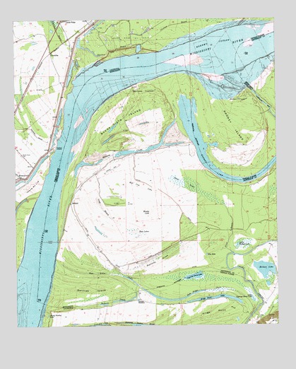
Chamblee, LA USGS Topographic Map
Click on map above to begin viewing in our Map Viewer.

This topographic map contains these locations and features:
Feature Name Type Latitude Longitude GNIS ID View Map
AshlandPopulated PlaceN31.8002°W91.3482°691671View Map
Baptizing SloughGutN31.7774°W91.3076°666513View Map
Bell Cow LakeBasinN31.8071°W91.3148°666779View Map
Bieller LightBuildingN31.8502°W91.2904°549516View Map
Blue HoleLakeN31.7790°W91.2839°667290View Map
Browns Field RevetmentLeveeN31.8715°W91.2821°549290View Map
Brushy LakeBasinN31.7954°W91.3112°667699View Map
Buena Vista (historical)Populated PlaceN31.8168°W91.3307°686412View Map
Buena Vista Church (historical)ChurchN31.8193°W91.3176°686413View Map
Buena Vista IslandIslandN31.8341°W91.3209°667757View Map
Buena Vista LandingLocaleN31.8166°W91.3354°707692View Map
Buena Vista Oil FieldOilfieldN31.8307°W91.3209°691010View Map
Burnett ChuteStreamN31.7668°W91.3173°533563View Map
ChambleePopulated PlaceN31.8615°W91.3579°541069View Map
Choctaw BayouGutN31.8632°W91.3271°533931View Map
Cottage BendBendN31.8571°W91.2504°686417View Map
Cypress Grove LakeLakeN31.7702°W91.2898°554171View Map
Durango Landing (historical)LocaleN31.7607°W91.3176°549305View Map
Durango PlantationLocaleN31.7602°W91.3171°534662View Map
Float BayouStreamN31.7791°W91.2712°670041View Map
Gilliam ChuteLakeN31.8184°W91.3350°670390View Map
Gilliam Chute Oil FieldOilfieldN31.8002°W91.3237°691013View Map
Gilliam LandingLocaleN31.8241°W91.2904°686420View Map
Goldman LandingPopulated PlaceN31.8232°W91.3554°543242View Map
Goldman Lower LandingLocaleN31.8107°W91.3607°549311View Map
Gum Ridge ChuteStreamN31.7549°W91.2623°535460View Map
Harper BayouStreamN31.8427°W91.2709°535535View Map
Harper LandingLocaleN31.8493°W91.2598°686421View Map
HedgelandPopulated PlaceN31.8152°W91.3668°549316View Map
Holmes LakeLakeN31.7730°W91.2562°671355View Map
Island Number Onehundred and TwelveIslandN31.8041°W91.3715°535958View Map
Kempe BendBendN31.8491°W91.3412°549323View Map
Kempe BendBendN31.8418°W91.3321°686423View Map
Kempe Bend RevetmentLeveeN31.8304°W91.3521°549324View Map
Kemps Bend BarBarN31.8335°W91.3446°686424View Map
Kings PointCapeN31.7571°W91.2734°554935View Map
Kings Point LakeLakeN31.7615°W91.2737°554936View Map
Little Cypress Grove LakeLakeN31.7605°W91.2619°555067View Map
Little Holmes LakeLakeN31.7829°W91.2691°672620View Map
Long BayouGutN31.7979°W91.3334°672793View Map
Millerfield (historical)Populated PlaceN31.8474°W91.3518°549335View Map
Myrtle Grove AirportAirportN31.8149°W91.3706°2717356View Map
Myrtle Grove CemeteryCemeteryN31.8199°W91.3721°537513View Map
New Zion Church (historical)ChurchN31.7771°W91.3312°686427View Map
News LakeSwampN31.8079°W91.2929°674910View Map
Old Kempe Bend RevetmentLeveeN31.8607°W91.3201°549346View Map
Pumping Station SloughLakeN31.7501°W91.3146°538438View Map
Rodney BendBendN31.8099°W91.2621°549353View Map
Rodney CutoffBendN31.8657°W91.2796°538683View Map
Rodney IslandIslandN31.8313°W91.2704°555824View Map
Rodney Island BarBarN31.8585°W91.2932°686435View Map
Rodney Island Oil FieldOilfieldN31.8504°W91.2682°549354View Map
Rodney LakeLakeN31.8143°W91.2815°555825View Map
Rodney LakeLakeN31.8091°W91.2687°676810View Map
Services IslandIslandN31.7652°W91.3418°677519View Map
Servis LandingLocaleN31.8333°W91.3500°2678170View Map
Shady Bradley LakeLakeN31.7545°W91.3600°556006View Map
Spithead TowheadAreaN31.8460°W91.3129°678056View Map
Twin LakesSwampN31.7877°W91.3179°679005View Map
Waterproof BarBarN31.7885°W91.3743°549377View Map
Waterproof Dikes (historical)LeveeN31.7766°W91.3721°549379View Map

Note: Coordinates in the location and feature list above are referenced to NAD83 datum.


Copyright (C) 2008-2024 Ryan Niemi / Sunset Dynamics ... All Rights Reserved