TopoQuest Logo
Do you find TopoQuest useful?
Help keep TopoQuest running and adding new maps/features by donating!
Bitcoin:  19c7KJd3qBynnjoSw5npx9KScwjBe4ifkT
Litecoin:  LXs6TkuXGGXo1vDsWCkWVdjQX94eUKd6ui
Home View Maps Find Maps Find Places Resources & Links


Gretna Green, Louisiana Topographic Map

USGS Map Title: Gretna Green, LA
USGS Map MRC: 31091H4
DRG (GeoTIFF) Download: o31091h4.tif


Neighboring USGS Topographic Map Quads:


  Como, LA  
32091A5
 

  Newlight, LA  
32091A4
 

  Saranac, LA  
32091A3
 

  Oakley, LA  
31091H5
 

  Gretna Green, LA  
31091H4
 

  Lake Bruin, LA  
31091H3
 

  Foules, LA  
31091G5
 

  Waterproof, LA  
31091G4
 

  Chamblee, LA  
31091G3


Map MRC Location:

N32°
W92°
N32°
W91°
H8 H7 H6 H5 H4 H3 H2 H1
G8 G7 G6 G5 G4 G3 G2 G1
F8 F7 F6 F5 F4 F3 F2 F1
E8 E7 E6 E5 E4 E3 E2 E1
D8 D7 D6 D5 D4 D3 D2 D1
C8 C7 C6 C5 C4 C3 C2 C1
B8 B7 B6 B5 B4 B3 B2 B1
A8 A7 A6 A5 A4 A3 A2 A1
N31°
W92°
N31°
W91°

Gretna Green, LA USGS 1:24K Topographic Map Preview:
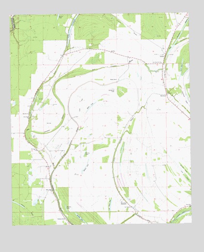
Gretna Green, LA USGS Topographic Map
Click on map above to begin viewing in our Map Viewer.

This topographic map contains these locations and features:
Feature Name Type Latitude Longitude GNIS ID View Map
AshlandPopulated PlaceN31.9749°W91.3923°542938View Map
Broad Lake (historical)LakeN31.9438°W91.4404°549289View Map
Brushy LakeLakeN31.8795°W91.4529°553809View Map
Bryland LakeLakeN31.9450°W91.3758°553819View Map
Chamblee Gas FieldOilfieldN31.8882°W91.3851°549295View Map
Cooter PointPopulated PlaceN31.9302°W91.4907°549299View Map
Crooked BayouGutN31.9921°W91.4187°534252View Map
Dickard BayouStreamN31.9310°W91.4840°534525View Map
Dixie (historical)Populated PlaceN31.9060°W91.4182°549303View Map
Gretna GreenPopulated PlaceN31.8793°W91.4635°543263View Map
Hard Bargin Gas FieldOilfieldN31.9918°W91.4515°549312View Map
Helena Oil FieldOilfieldN31.8918°W91.4193°549317View Map
Holly RidgePopulated PlaceN31.8957°W91.4718°541110View Map
Holly Ridge ChurchChurchN31.9390°W91.4876°535728View Map
Holly Ridge Gas and Oil FieldOilfieldN31.9068°W91.4751°535733View Map
JustinaPopulated PlaceN31.9774°W91.4296°541118View Map
Lake Black DogLakeN31.8862°W91.4315°553678View Map
Lake FormosaLakeN31.9925°W91.4570°554457View Map
Levi LakeLakeN31.9687°W91.3805°555028View Map
Little Choctaw BayouStreamN31.9085°W91.4704°536515View Map
Long LakeSwampN31.9460°W91.4512°536701View Map
Mackey LakeLakeN31.8851°W91.4624°555207View Map
MayflowerPopulated PlaceN31.9515°W91.3915°541138View Map
Mayflower CemeteryCemeteryN31.9654°W91.3996°536946View Map
Miller LakeLakeN31.9449°W91.4444°555325View Map
Monclova ChurchChurchN31.9199°W91.4826°537177View Map
New China Grove ChurchChurchN31.9704°W91.3948°537561View Map
New Hope ChurchChurchN31.8852°W91.4173°537578View Map
New Zion ChurchChurchN31.9415°W91.4876°537651View Map
North Holly Ridge Oil FieldOilfieldN31.9463°W91.4710°549343View Map
Pecan BrakeSwampN31.8846°W91.4901°538040View Map
Shady GrovePopulated PlaceN31.9613°W91.4248°541188View Map
Snodgrass LakeLakeN31.9550°W91.4276°556079View Map
Spring Hill ChurchChurchN31.8857°W91.3754°539595View Map
Sundown Oil FieldOilfieldN31.9335°W91.4023°549370View Map
Tensas Parish Fire District 1 Station 7BuildingN31.9677°W91.3943°2673013View Map
Tensas Parish Fire District 1 Station 8BuildingN31.9140°W91.4772°2673012View Map
Turkey LakeLakeN31.9188°W91.4482°556282View Map
Wavertree PlantationLocaleN31.8896°W91.4221°556377View Map
Wesley ChurchChurchN31.9529°W91.3909°1964792View Map
Wilson LakeLakeN31.9076°W91.4501°556453View Map

Note: Coordinates in the location and feature list above are referenced to NAD83 datum.


Copyright (C) 2008-2024 Ryan Niemi / Sunset Dynamics ... All Rights Reserved