TopoQuest Logo
Do you find TopoQuest useful?
Help keep TopoQuest running and adding new maps/features by donating!
Bitcoin:  19c7KJd3qBynnjoSw5npx9KScwjBe4ifkT
Litecoin:  LXs6TkuXGGXo1vDsWCkWVdjQX94eUKd6ui
Home View Maps Find Maps Find Places Resources & Links


Lake Bruin, Louisiana Topographic Map

USGS Map Title: Lake Bruin, LA
USGS Map MRC: 31091H3
DRG (GeoTIFF) Download: o31091h3.tif


Neighboring USGS Topographic Map Quads:


  Newlight, LA  
32091A4
 

  Saranac, LA  
32091A3
 

  Newellton, LA  
32091A2
 

  Gretna Green, LA  
31091H4
 

  Lake Bruin, LA  
31091H3
 

  Saint Joseph, LA  
31091H2
 

  Waterproof, LA  
31091G4
 

  Chamblee, LA  
31091G3
 

  Rodney, MS  
31091G2


Map MRC Location:

N32°
W92°
N32°
W91°
H8 H7 H6 H5 H4 H3 H2 H1
G8 G7 G6 G5 G4 G3 G2 G1
F8 F7 F6 F5 F4 F3 F2 F1
E8 E7 E6 E5 E4 E3 E2 E1
D8 D7 D6 D5 D4 D3 D2 D1
C8 C7 C6 C5 C4 C3 C2 C1
B8 B7 B6 B5 B4 B3 B2 B1
A8 A7 A6 A5 A4 A3 A2 A1
N31°
W92°
N31°
W91°

Lake Bruin, LA USGS 1:24K Topographic Map Preview:
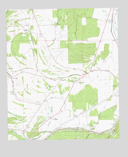
Lake Bruin, LA USGS Topographic Map
Click on map above to begin viewing in our Map Viewer.

This topographic map contains these locations and features:
Feature Name Type Latitude Longitude GNIS ID View Map
Andrews BayouGutN31.9521°W91.2621°532172View Map
AubreyPopulated PlaceN31.9321°W91.3207°549281View Map
Aubrey Oil and Gas FieldOilfieldN31.9257°W91.3318°549282View Map
AvondalePopulated PlaceN31.9404°W91.2818°542943View Map
Avondale PlantationLocaleN31.9440°W91.2757°549283View Map
Brushy LakeLakeN31.8979°W91.3732°553814View Map
Buckhorn Oil FieldOilfieldN31.9713°W91.3151°553823View Map
China Grove ChurchChurchN31.8890°W91.2565°533919View Map
Cindy Lake (historical)LakeN31.8877°W91.3359°549296View Map
Cottage Bend RevetmentLeveeN31.8813°W91.2557°549300View Map
Cow LakeSwampN31.8979°W91.3734°534211View Map
CrimeaPopulated PlaceN31.9771°W91.3365°541080View Map
Crimea Gas FieldOilfieldN31.9763°W91.3404°549301View Map
Cross KeysPopulated PlaceN31.8840°W91.3579°541081View Map
Cross Keys CemeteryCemeteryN31.9004°W91.3709°534285View Map
Delta BridgeLocaleN31.9354°W91.3696°534491View Map
Delta Bridge Oil and Gas FieldOilfieldN31.9579°W91.3598°1631094View Map
DenhartPopulated PlaceN31.8974°W91.2976°541085View Map
Dry BayouGutN31.9427°W91.3582°534589View Map
Duck LakeLakeN31.9038°W91.3247°554285View Map
Flowery Mount ChurchChurchN31.9396°W91.2615°554443View Map
Fox LakeLakeN31.8954°W91.3322°554470View Map
Fox Lake GAs FieldOilfieldN31.8924°W91.3287°549307View Map
Gibson PlantationLocaleN31.8943°W91.3232°535212View Map
Gin LakeLakeN31.9795°W91.3693°554535View Map
Gin LakeSwampN31.9218°W91.3540°535233View Map
Gold Bell CemeteryCemeteryN31.9740°W91.3354°535259View Map
House LakeSwampN31.9482°W91.2765°535832View Map
Hubbard BridgeBridgeN31.9154°W91.3134°549319View Map
Jackson LakeLakeN31.9250°W91.3287°554858View Map
Lake BruinPopulated PlaceN31.9879°W91.2562°543372View Map
Lake Saint Peter CanalCanalN31.8860°W91.2940°536298View Map
Lake TwentynineSwampN31.9863°W91.3723°540063View Map
Little Choctaw BayouGutN31.9349°W91.3112°536513View Map
Lockner Lake (historical)LakeN31.9010°W91.3209°549330View Map
Locust RidgePopulated PlaceN31.8765°W91.3418°536655View Map
Locust Ridge Oil FieldOilfieldN31.8910°W91.2890°555122View Map
Locust Ridge PlantationLocaleN31.8793°W91.3343°549331View Map
MarylandPopulated PlaceN31.9227°W91.3687°543451View Map
Maryland Baptist ChurchChurchN31.9193°W91.3676°555247View Map
MAryland PlantationLocaleN31.9174°W91.3701°549333View Map
Mound CemeteryCemeteryN31.9296°W91.3009°549336View Map
Mound Hedren ChurchChurchN31.9299°W91.3007°537280View Map
Mound PlantationLocaleN31.9307°W91.2976°537281View Map
Oneonta CemeteryCemeteryN31.9149°W91.3243°555564View Map
Oneonta ChurchChurchN31.9124°W91.3312°537881View Map
OsceolaPopulated PlaceN31.9696°W91.2529°537903View Map
Parish Governing Authority District 4CivilN31.9615°W91.3579°1930039View Map
Ridgeland PlantationLocaleN31.9424°W91.3001°549352View Map
Routh BayouGutN31.9790°W91.3212°538753View Map
Routh DitchCanalN31.9952°W91.2626°538754View Map
Saint Lena ChurchChurchN31.8965°W91.3273°538934View Map
Shilake ChurchChurchN31.9977°W91.2504°539333View Map
Tensas Flying ServiceAirportN31.9820°W91.2634°2676791View Map
Thistle Ridge CemeteryCemeteryN31.9849°W91.3501°539869View Map
Thistle Ridge PlantationLocaleN31.9796°W91.3501°539870View Map
Van Buren BayouGutN31.9252°W91.3682°540136View Map
Villa Clara ChurchChurchN31.8879°W91.2823°540169View Map
Ward FourCivilN31.9518°W91.3321°545215View Map
WilsoniaPopulated PlaceN31.9329°W91.3143°543790View Map

Note: Coordinates in the location and feature list above are referenced to NAD83 datum.


Copyright (C) 2008-2024 Ryan Niemi / Sunset Dynamics ... All Rights Reserved